Chapter XI <<< Version Française >>> Chapter XIII
Today Charmutha’s quest ends with this final set of three chapters. After having described the Betius, this river which crossed the Hedjaz and threw itself into the Red Sea, after having described the immense lagoon in which two thousand boats could moor, after having described the Cothone with its two port basins, after having describes the Acropolis of Badeo with its three temples, we have one last and final question: what could this region represent for the neighbors, in particular for the Egyptians? Our objective is to demonstrate that the Charmutha’s harbor but also the Acropolis of Badeo were known among the Egyptians under the name of Ta Netjer or God’s Land (chapter XII) and, more, as the birth’s country of the god Osiris (chapter XIV). Step by step, question after question, we will provide the historical documents that will lead to this unprecedented conclusion which will have to be validated by the scientific community. Regardless, the fame of this port went beyond its homelands.
Chapter XII: Betius, Chamuthas : God’s land and Charmuthas.
The Charmuthas’ region was famous in the ancient world, as Diodorus the Sicilian reminded us: « And below, a Quersonesse where there is one of the best ports which is written in all the stories called Charmuthas… » This port known beyond its homelands must have been with their nearest neighbors, the Egyptians. And yet, among all the hieroglyphic texts, there is no trace of such a name. This famous region could not be ignored and was to be known differently, under another name, as an exceptional country whose location we still lack. And in the imagination of Egyptologists, there is indeed such a country called Punt or Ta Netjer. Would there then be a link between Charmuthas/Badeo and Pount/TaNetjer?
Since the beginning of this other quest, that of Ta Netjer, many specialists have tried to place this God’s land on a map. Unfortunately, and despite the many hypotheses put forward, none of them has enabled us to find the foundations of such a civilization. Our approach today differs from others as we start from a site with the remains of a lost civilization but also famous beyond its lands. And we search for its name among the closest neighbors, the Egyptians. On the one hand we have an archaeological site impressive for its size and on the other a imaginary land, famous beyond its homelands. This correspondence between Charmuthas/Badeo and Pount/TaNetjer is, therefore, credible enough for us to think about it.
To demonstrate if such a correspondence exists or not, we will develop our arguments to confirm this theory by asking the questions necessary to solve this riddle, one after the other.
Question n°1: What is the difference between Punt and Ta Netjer?
These two countries actually represent two well-defined and distinct geographical areas as confirmed by this parallel in hieroglyphics: “Incense [mnwr, incense] like [m, in, with, like, as] that [hms, perfume, aromatics, incense] of Ta Netjer [Tȝ-nṯr] that exports [pr, out] Pount [Pwnt]” (personalized interpretation, reference n ° 62, KIU4229, “Offering of incense”, Scene 02.O (Opet 253), figure XII.a). Here, this parallel cites Pount and Ta Netjer at the same time, which confirms a geographical distinction between these two countries.
In one of the Deir el-Bahri frescoes, the Pharaoh’s messenger landed in the God’s Land before the fleet to meet the chiefs of Punt there: “[The arrival] of king’s messenger in God’s-land, together with the army which is behind him, before the chiefs of Punt; « . The Punt’s king had then come especially to Ta Netjer to meet the Egyptian ambassador there. Another fresco described the ships’ loading: “The loading of the ships very heavily with marvels of the country of Punt; all goodly fragrant woods of God’s-Land… with green gold of Emu…” (Frescoes of Deir el-Bahri, reference n°25, page 265). From this list of products brought from Punt to the pharaoh, there were at least two countries mentioned: Ta Netjer with its fragrant woods and Emu with its green gold.
Because of the meeting location but also the products coming from Ta Neter and Emu, we can deduce that Ta netjer was one of the countries of the kingdom ruled by the Punt’s chiefs.
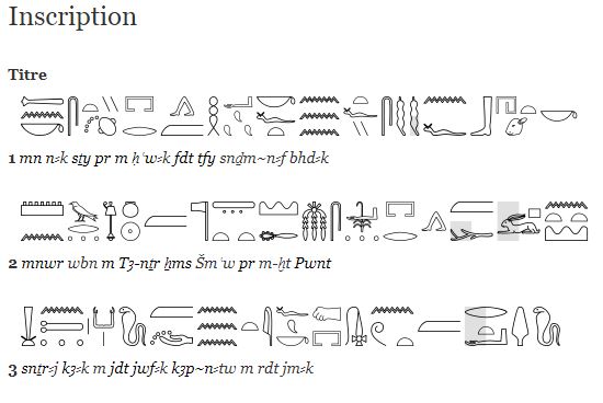
Incense *** [in, with, as] Ta-netjer [perfume, aromatics, incens] go out *** Punt
Figure XII.a: parallel in hieroglyphics, KIU4229, « offering of incense », Opet’s temple (reference n°62) with its partial translation below:
Question n°2: What did Punt represent for the Egyptians?
After demonstrating that Ta Netjer was one of the Punt’s countries, our reflection continues to define what Punt could be. In the 19th century, at the beginning of the science of Egyptology, specialists associated this kingdom with Arabia. But the discovery of the Deir el Bahari frescoes called into question this hypothesis since the animals represented were those of a savannah. The Horn of East Africa then became the new location accepted by the scientific community. One of my previous studies (Chapter VII: the kingdom of Punt and its countries) had made it possible to contradict this hypothesis since I had enumerated many animals that have disappeared meanwhile in the Arabian Peninsula and this in the pharaohs’ time: giraffe, elephant, rhinoceros, lion… The main argument of an African kingdom is therefore now obsolete since there was another savannah outside Africa, precisely on the Asian continent, and this savanna disappeared as a result of climate cooling.
After having expressed doubts about an African localization of Punt, I had shown that the kingdom could only be inside the Red Sea since the Egyptian fleet docked the Punt’s shores before reaching the Indian Sea: “ They were sent forth into the great sea of the inverted water ”(Volume IV, Papyrus Harris, 20th Dysnatie, Ramses III, page 108 and 203 of Volume IV, page 1359 of the book, §181 and §407). The “inverted waters” should be interpreted here as “ebbs and flows” of the Greeks (Skylax, reference n°46) and simply means “tide”. In the Red Sea as in the Mediterranean, the tidal range is low, while at the exit of the Aden Gulf, the tidal amplitude is double and can reach 50 cm. For the Egyptians, this « great sea of inverted waters » was the Indian Ocean. According to our analysis based on the texts of the Harris papyrus, Punt’s shores must necessarily have been located before the Aden Gulf and therefore inside the Red Sea. Three other arguments support our theory of a country inside the Red Sea:
1 – According to the Dead’s Book (reference n ° 63), the kingdom of Punt was a volcanic region: « O Lord of the great dwelling, chief of the gods, save Osiris N from this god with the greyhound’s face and the eyebrows of man which lives overthrown. There is a fold of the fire’s basin which absorbs the bodies for the entrails’ removal and the corpses’ rejection by the one who cannot be seen. What is this? He who devours multitudes is his name, he is in the Punt basin. The fire’s basin is in Anroutef, towards Sheni; whoever arrives impure will fall immolated”. In this ancient funerary text, the fire’s basin can only be one gigantic lava flow, among all those called Harrat. Some of them are quite recent since the last date from the Middle-Age and Mohammedan pilgrims could observe their lights from Mecca. In figures XII.b (reference n ° 64) and XII.c (reference n ° 65), we can observe all the basaltic fields around this region with the main volcanoes. We can see that the main volcanic areas are inside the Red Sea, and more precisely along the Arabian Peninsula or at the end of the Rift Valley called Afar. Outside the Aden Gulf, we do not find any remains of an ancient lava flow that could correspond to « fire’s basin » of Punt described by the « Dead’s Book ».

Figure XII.b: the great rift valley (Wikipedia, reference n°65)
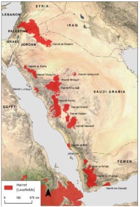
Figure XII.c : Map of the lava fields in the Arabian Peninsula, the Harrats.© David Kennedy (reference n°64)
2 – To access Punt, fairly rudimentary boats were sufficient to reach its coast (figure XII.d, reference n ° 66). Figure XII.c shows two which, according to L. Bradbury, returned to Punt with Egyptian products. These boats consisted of a skin balloon (inflatable balloon) like our zodiacs today. Despite their lightness, they were sufficient to carry people who were not sailors like this woman with her child. The analysis of these small boats proves that Ta Netjer was not very far from the shores of ancient Egypt since these frail ships were not intended to face a raging sea and therefore to travel on the waters of the Indian Ocean.
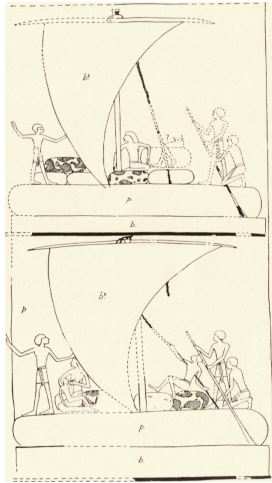
Figure XII.d: the Punt’s raft (N. de G. Davies, « The work of the Graphics Branch of the Expedition », BMMA II, 1935, pour. 47, fig.2, reference n°67)
3 – Among the products reported from Punt, one of the most cited was myrrh: « Two vessels heavily laden with myrrh trees, sacks of myrrh, ivory, woods, apes… ». It turns out that in the first century, according to Pliny the Elder, there were only two countries that produced this myrrh: « The analogy would require that I speak of cinnamon, if it was not appropriate to indicate beforehand the Arabia’s wealths, and the causes which gave it the name happy and fortunate. The main products of this region are frankincense and myrrh. Myrrh is common to him with the land of the Troglodytes; but frankincense is not found elsewhere than in Arabia, and even it is not found in all of Arabia. » (Pline l’Ancien, livre XII, reference n°43). According to this Roman author, this myrrh was produced by only two countries and both were inside the Red Sea.
With all these remarks (the Indian Ocean with « inverted waters »; the basin of fire described in the « dead’s book »; the boats too small to face up a raging sea…), Punt must necessarily be inside the Red Sea… The myrrh production areas provide additional information since we can focus on the two countries mentioned by Pliny: the Arabian Peninsula or the land of the Troglodytes. On the other hand, as we know the main direction of this kingdom (east for the Egyptians), we can privilege the kingdom of the Arabs: « When I turn my face to the Orient, I work a wonder for thee; I cause to come to thee the countries of Punt » (Amon Hymn, Tome II, 18th dynastie, Amenhotep III, Soleb Temple, page 360 of Tome, page 755 of book, §892).
There is a second reason to favor the Arabian Peninsula since in the first century AD, it was the only region that produced incense (Pliny the Elder, book XII, reference n ° 43). The Roman’s claim may seem surprising since there are other species of frankincense tree: Boswellia papyrifera in southern Egypt, Boswellia frereana in Somalia and Boswellia serrata in India (reference no.67, page 138, figure XII.e). But their quality is lower than that of Boswellia sacra which only grows in Happy Arabia (figure XII.e). This last species, that of the Arabs, was the most sacred since it produced the incense necessary for funeral rites. Its Latin and scientific name recalls this sacredness: « Boswellia sacra ». At this time, Felix Arabia was therefore the one and only country to provide funeral incense. This botanical study in addition to the previous remarks confirms our theory on a correspondence between the kingdom of the Arabs and this mysterious country called Punt.

Figure XII.e : Distribution of frankincense trees and their species (Nicole Boivin, Dorian Q. Fuller, figure 9, reference n°67).
Question n°3 : Where was Ta Netjer located?
There is little information that can help to position Ta Netjer, and therefore locate it near Jeddah. And among all this information, only two of it is really usable:
1 – Papyrus Harris (Tome IV, Papyrus Harris, 20th Dysnaty, Ramses III, page 203, §407): « They were sent forth into the great sea of the inverted water, they arrived at the countries of Pount, no mishap overtook them, safe and bearing terror… Their chief’s children of God’s-Land went before their tribute advancing to Egypt…»
2 –Deir el Bahari frescoes (reference n°25, page 107 of Tome II, page 481 of book, §257): « … Did you come down upon the ways of heaven, or did you sail upon the waters, upon the sea of God’s-Land? … »
The first testimony, that of the Harris papyrus, describes the meeting between the Egyptian fleet and the Punt’s chiefs. The Pharaoh’s messenger had organized and planned this meeting on the God’s Land called Ta Netjer. This historic event took place on the shores of the Red Sea since the boats had not reached the Indian Ocean nicknamed the « sea of inverted waters » by the Egyptians. The messenger had at the same time negotiated the coming of the children of the God’s Land to Egypt so that they could be the peace’s guarantors between these two nations.
The second testimony, that of the Deir-el-Bahiri frescoes, relates the description of the Red Sea by the Punt’s chief: « the sea of Ta Netjer« . This name implies that the waters of this sea came from the God’s Land and therefore from a river. This river, along the coast of the Red Sea, can only be Betius, which explains the presence of pure or brackish water fish including Tilipia on the frescoes (figure XII.f).

Figure XII.f: Representation of Punt’s fish including Tilapia.
In addition to these two remarks, it is possible that « Charmuthas » (Χαρμοθᾶς in Greek) could be the “God’s Land” in a Hellenic form (see Chapter X: The Cothon of Charmutha). The suffix « Χαρμο» could be the Greek word « Χαρμα » and therefore recall the description of the port made by Diodorus: « And below a Quersonnesse where there is one of the best ports which is described in the stories named Charmutha: because under a rock which looks straight at the setting sun, the sea there is not only pleasant, but surpassing all others in goodness and profit ». As for the suffix Tha (θᾶς), it could mean the divine country since in Coptic (Coptic Dictionnary, reference n°69), To/θo/Tα designates the country and the inspiration θ could be an allusion to the gods and goddesses θεός/θεά. The use of the Coptic word Tha by Greek navigators is not inconsistent because we also use foreign words to designate countries such as, for example, the suffix STAN for AfghaniStan (Afghans’ country), PakiStan (land of the pure men)… Anyway, the etymology could suggest a link between Charmutha and « God’s charming land ». Who knows if Charmutha, the name of this ancient harbor, was not a Greek translation of “Ta Netjer”.
Figure XII.g : Landscape of the region called Ta Netjer, Charmutha or Mecca respectively, depending on the period.
In conclusion of this chapter, our theory of a similarity between Charmutha and Ta Netjer becomes quite credible today, but it is based on 2 postulates: the « sea of inverted waters » is the Indian Ocean; « The sea of Ta Netjer » is the Red Sea for the Arabs because of the river which crossed the God’s Land and which flowed into this sea. At this stage of our reflection, our arguments are few and too debatable to validate our hypothesis. This is why we will have to provide other testimonies to support this novel theory. The last chapter will reveal the name of the God of this region called differently according to the times: Ta Netjer, Charmutha or Mecca. This Arab God in the Egyptian pantheon will then unveil the grandeur of this harbor but also the daily life of the Meccans of this distant time, of the time of Ramses and Abraham (see figure XII.g). But first, it seemed interesting to me to take a detour through the Cyclades. The fame of this ancient country could transcend borders and influence places as far away as the island of Santorini.
Bibliographie/Bibliography : Ci-joint la bibliographie complète
25 – « Ancient Records of Egypt » de J.H. Breasted :
https://archive.org/details/BreastedJ.H.AncientRecordsEgyptAll5Vols1906
62 – KIU4229, « Offrande de l’encens », Scène 02.O (Opet 253)
http://sith.huma-num.fr/karnak/4229
63 – « Le livre des morts des anciens égyptiens : traduction complète d’après le papyrus de Turin »,
https://archive.org/stream/lelivredesmorts00piergoog#page/n109/mode/2up/search/Anroutef
64 – « Le mystère des portes d’Arabie », Science et Avenir :
https://www.sciencesetavenir.fr/archeo-paleo/archeologie/le-mystere-des-portes-d-arabie_118488
65 – « Map of the Great Rift Valley », Wikipedia :
https://fr.wikipedia.org/wiki/Fichier:Great_Rift_Valley_map-fr.svg
67 – « The work of the Graphics Branche of the Expedition », BMMA II, 1935, p.47, fig.2.
68 – « Shell Middens, Ships and Seeds : Exploring Coastal Subsistence, Maritime Trade and the Dispersal of Domesticates in and around the Ancient Arabian Peninsula », Nicole Boivin, Dorian Q. Fuller, J. World Prehist (2009) 22 : 113-180 :
69 – « A coptic dictionnary « , W.E. Crum, 1939, Oxford :
