The city of Charmutha/Punt with all its merchants and colonies was one of the greatest maritime powers of High Antiquity. His ships, which sailed the many seas, opened up new trade routes that allowed cultural exchanges between very distant regions. All these ways, as were later the roads of Rome, the railways or the Internet, are as many interconnections which allowed the emergence of new technologies and their diffusion between various countries more or less advanced between them. This Red Sea port, as large as Carthage, was at the heart of ancient civilizations (Mesopotamia in the North, Egypt in the West, Crete in the North-West and Harappa in the North-East) and contributed in its own way the spread of the first writings to many regions whether or not they are close to the Arabian Peninsula. However, the use of the alphabet did not occur spontaneously or progressively but rather through successive stages: the pictogram with its realistic graphics (man, woman, animals, etc.), the ideogram with its realistic and abstract graphics (running, walking, river, beauty, etc.), the phonogram (symbols associated with phonemes) and finally the alphabet (symbols associated with primary phonemes).
Today, the invention of writing and its dissemination must be conceived through multiple exchanges between regions more or less technically advanced between them, and also more or less distant. These commercial and cultural relations are one of the keys to understanding the ideograms and/or logograms that developed all around the Near East, including those in Crete (hieroglyphs and Linear A) which are a mutual legacy of neighboring powers. A comparison of Cretan, Egyptian and Mesopotamian glyphs (proto-cuneiform and non-cuneiform) suggests three ways in which ideograms spread, and these in three different times: a first spread, in the 4th millennium BC, from Mesopotamia (glyphs created around -3,400 years BC) to Egypt (glyphs resumed around 3,200 years BC) following the first commercial exchanges via Ta Netjer (Happy Arabia); later, the second, in the 3rd millennium BC, from Ta Netjer (Charmutha/Punt being one of the countries) to new more distant regions including the Cretan island (Minoan hieroglyphs) with the invention of high-speed boats. sea ; then finally, the third in the second millennium BC, from Egypt to Pount/Charmutha and its colonies following an increased influence of the country of the pharaohs which imposed its hieroglyphs and its simplified writings called hieratic.
This theory of a diffusion in three times may seem surprising but it offers a coherent interpretation to all Egyptian, Phoenician and Minoan mythologies that I will deepen in my following articles, in particular on the Zero dynasty of the pharaohs. All these commercial and cultural exchanges which date back to High Antiquity are one of the main factors in the spread of Sumerian glyphs (those of the Uruk period) to Divine Arabia (Happy Arabia, Ta Netjer) then to Egypt and Crete. Professor Luigi Pernier had already suspected such an influence of Punt (Charmutha, Arabia Heuseuse) on the Minoan civilization because of the dwellings on the disc of Phaistos and on the frescoes of Deir el Bahari (reference n°148, Godard Louis). As for Professor Maurice Dunand, he had noted similarities between Linear A of the Minoans, the Byblos’ scripts and the Egyptian writings (reference n°149, Dunant Maurice). My article today proposes to study one of the axes of influence, that which goes from Divine Arabia (Happy Arabia) to Egypt and which existed at the time of Pharaoh Narmer. All these investigations and analyzes will ultimately provide an unprecedented look at the writing’s birth.
1 – Primary Scripts and the invention of the alphabet:
Before defining what the primary scriptures could be, it is important to recall the four main phases of the alphabet’s invention:
The pictogram which is a set of rather realistic graphic symbols of men, women, animals and certain more complex notions: the hunter with his bow and his arrows, the shepherd with his stick…
The ideogram or logogram which is a more complex representation than the pictogram since it also includes abstract notions such as verbs or ideas: RIVER, NICE, BEAUTIFUL, GREAT, WALK, RUN…
The phonogram which is a set of graphic signs mainly associated with sounds. The words here are a succession of symbols which gives its equivalent phoneme: [RI]-[VER], [NI]-[CE].
And finally, the alphabet which is a primary decomposition of phonemes : [R-I]-[V-E-R], [N-I]-[C-E].
The pictograms in themselves do not allow structured writing since many abstract notions are absent. On the other hand, the ideograms or logograms turn out to be sufficiently developed for us to be able to consider them as the first symbols of the primary scripts.
On the Egyptian side, the inventor of writing and language is Thoth, also nicknamed the « language of Atum » or Gods’ scribe. The embodiment of intelligence and speech, he knows the incantations the gods cannot resist. According to legend, anyone who was able to decipher the magic formulas of the Book of Thoth could hope to surpass the gods. All the sciences are in his possession: He knows everything and understands everything. As the holder of knowledge, he is responsible for disseminating it. If the ancient Egyptians revered him so much, it is because all the Knowledge and Knowledge had been transmitted to them by books and writings that Thoth had voluntarily abandoned in temples.
Among the Phoenicians, the inventor of writing this time is Taut, whose phonetic resemblance is not fortuitous with the god Thoth since numerous inscriptions present that the Egyptian divinity as being the « Lord of Punt », the one of the countries of Divine Arabia (Felicia Arabia, reference n°150):
· An inscription on a Ramesside monument in Sinai identifies the moon god Thoth as the Lord of Ta Netjer (Référence n°151, Inscription in Sinai, [KRI II 401,14], cf. Shaheen, Alaael-din M., Thot, « Lord of Punt »; A brief note, GM 165 (1998), 9-11).
· On the sandstone statue of Ramses (Object reference 1905,1014.124, British Museum, reference n°152), two names were engraved: « Hathor, Lady of Turquoise and Thoth, Lord of Punt »
If Thoth is a god of Punt, could it be that he is a Warlord from the Asian continent who has meanwhile become king of Egypt and who disseminated his hieroglyphs in his adopted country? If so, the sacred writing of the Egyptians would then be an import from the Arabian Peninsula. To validate or not this theory, we must go back to the first hieroglyphs of the 4th millennium BC, on the Thinite period, to detect traces of such an origin. These symbols, in this distant time, did not yet constitute complete sentences such as we know (subject, verb and object) but certain associations began to give nominal groups (object with its adjective). Their first use was to name the first pharaohs with royal cartouches called Serekh of Horus. Despite the passage of time, the names of several of them have been preserved: Horus the falcon, Houroui the double falcon, the scorpion, Narmer, …
Anyway, the first hieroglyphs date back to the Narmer’s reign with his first nominal groups that we find on different objects: macehead (Figure XVI.a, reference n°153), palette (Figure XVI.b, reference n°154) and baboons’ statuettes (Figure XVI.e, reference n°155). An in-depth study of all these old historical pieces (including the frescoes of Sethi) suggests a real Asian origin to this pharaoh of the Zero dynasty without however validating this theory.
2 – Pharaoh Narmer, master of hieroglyphs and foreigner to the land of Egypt :
On his famous palette (see figure XVI.b) where the first hieroglyphs appear, Pharaoh Narmer celebrates his victories with many massacres of enemies and beheadings of prisoners. On the front, from top to bottom, the royal cartouche of Narmer (K13+U22, “spicy catfish”) is surrounded by two bulls. Slightly below, on the right, a friendly or enemy boat is taken by Horus the Falcon to the shores of Egypt. The scene continues with Pharaoh Narmer (K13+U22) finishing off an enemy with his mace. This pharaoh surrounded by his two main companions, his Shaman (the Flower, double M42) and his Quartermaster (V13 the rope for the blows of the whip and X1 the caring bread), wears the headdress of Upper Egypt. At the very bottom, two enemies cowered in fear have taken refuge (hieroglyph V7, a cord in the shape of a bracelet to express protection) in their fortress (hieroglyph O16/O13, the fortress).
On the back, at the top, we have the same Serekh surrounded by two bulls. Below, the pharaoh with the crown of Lower Egypt goes to war with his two companions (his Shaman and his Quartermaster represented by the hieroglyphs M42 and V13-X1) and the representatives of 4 nomes. His defeated enemies suffer the ultimate punishment of death by decapitation. Below, a battle has been represented between two imaginary animals, Serpentard that I will rather call them « leocamelopardalis ». And finally, at the very bottom, the scene ends with a bull smashing through the enemy’s fortress.
The first interest of this old palette is the appearance of the first hieroglyphs, some of which form nominative groups: K13+U22 for the Pharaoh Narmer, V13+X1 for the Quartermaster. This is why Narmer was the first pharaoh to understand the importance of the scriptures and to use them to manage his kingdom.
The second interest is the battle between the two imaginary animals which are often called Serpentard (contraction of Serpent and Leopard) but which I prefer to call them “leocamelopardalis”. These imaginary animals, leopards with long necks, are not the fruit of human imagination but rather the fruit of a linguistic misunderstanding between the sponsor Narmer and his master blacksmith. The pharaoh had asked for a battle between two « camelopardalis » (spotted camels to designate giraffes) but the craftsman included a scene with two « leopardalis » (spotted lions to designate leopards). Finally the animals represented are « leocamelopardalis » which turns out to be a mixture of « camelopardalis » and « leopardalis », a mixture of giraffe and leopard, which gives long-necked leopards. This scene on the Narmer palette thus demonstrates a pharaoh of foreign origin in relation to his local population.
Therefore, if this pharaoh was not an ethnic Egyptian, he who mastered the first sacred scriptures, then where could he come from?
3 – Narmer, a Red Sea pirate who became pharaoh :
My hypothesis on Narmer here is a pirate of the Red Sea who, following several raids on the lands of Egypt, became pharaoh. Here are five clues that support my theory without completely validating it:
The Sethi’s frescoes describe the offerings of the four peoples of Egypt to the pharaoh: the “romets” of Middle Egypt; the “aamouts”, a people of Lower Egypt of Asian origin; ”Neyesyou”, a people from Upper Egypt with sub-Saharan origins and the ”Timihou”, Libyans from the western deserts of Egypt (see figure XVI.c). Here, the most similar Egyptians to Narmer are the « aamout » with their trimmed beards, which logically gives an Asian origin to this pharaoh.
Clue n°2: the imaginary animal represented on Namer’s serekh:
According to the royal cartouches, the pharaoh’s emblem is officially a catfish, and in particular one of the following two species: « Heterobranchus longifilis » or « Malapterurus electricus ». But this hieroglyph presents at least four inconsistencies: 1- there are two hieroglyphs K13 and K4 to represent the catfish; 2- the presence at the same time of these two animals K13 and K4 on the Kagemni fresco; 3- Narmer’s hieroglyph A54 which is a chimera consisting of a lateral back and a flat head with two eyes; 4- the six vibrissae of catfish much lower than the ten drawn. This is why Narmer’s hieroglyph A54 is not a catfish but rather a cuttlefish with ten tentacles, which is confirmed by Bugdoff’s dictionary in which the word [nar] does designate a mollusk there.
Attention, in the dictionary of Vygus, this same Egyptian word [nar] means « catfish » whereas the cuttlefish isn’t mentioned there. To explain this difference between the two dictionaries, [nar] could be interpreted as a multi-tentacled fish, which gives us both « cuttlefish » and occasionally « catfish ».
Vintage engraving of The Kraken, as Seen by the Eye of Imagination, 19th Century. The Kraken is a legendary sea monster of large proportions that is said to dwell off the coasts of Norway and Greenland.
Figure XVI.d: the myth of Kraken
A question then arises: if the hieroglyph represents a cuttlefish for Narmer, could this mollusk of the seas be the emblem of this pharaoh? The answer is yes if the symbol does not represent the small animal but the giant squid, this terrifying animal that dared to attack boats (figure XVI.d). This hieroglyph K13 therefore confirms us on the theory of a pharaoh with foreign origins, and also of a man of the seas.
Clue n°3: the boat represented on the front guided by the Horus falcon:
For many specialists, this boat represented on the front symbolizes the arrival of enemies on Egyptian lands. But, at the very bottom of the palette, we can see that his enemies have taken frightened refuge in their fortress, which for me excludes a come by boat. Therefore, I favor another interpretation, that of an incursion of Narmer and his men into African lands. These sailors were then pirates who launched raids on the countries of Egypt and who by chance of fate became masters of Upper Egypt.
Clue n°4: the chronological order of events between the two sides of the palette:
The chronology of the two faces brings another look at the journey of this pharaoh. On the recto, accompanied by his two companions (the Shaman and the Quartermaster), Narmer wears the crown of Upper Egypt. While on the verso, the pharaoh wears the crown of Lower Egypt followed by his two companions and representatives of 4 nomes of Middle Egypt against the northern countries. The difference between the two faces are the standard bearers, which induces an installation in Upper Egypt before Lower Egypt. Following this chronological order, these pirates could not have come from the Mediterranean, via the Nile delta. They had therefore taken another path, less known, that of the Canal of the Pharaohs, which was an arm of the Nile and which flowed into the Red Sea. The comparison between two sides thus suggests an arrival of Namer from the Arabian Gulf and not from the Mediterranean.
Clue n°5: the papyrus represented on the boat and on which lies Horus the Falcon:
The desire to represent a flowering reed on which Horus the falcon rests is not insignificant since this plant is a strong symbol in Egyptian culture. For the inhabitants of the Nile, the divine paradise is a plain of reeds known as the field of « Ialou ». We can therefore see an allusion to the divine country called Ta Netjer or Punt and especially to the lagoon of Charmutha ( Chamutha(s) the gods land (or Punt) ).
8 – Conclusion:
In conclusion, Narmer was a pirate from the Middle East (probably from Charmutha) who settled in Egypt following a raid and who granted himself the thrones of Upper and Lower Egypt. This violent man was at the same time cultured because he understood the importance of hieroglyphics in the management of a country. Question about this pharaoh: could he leave an important trace in the history of Egypt? probably yes if we notice that the word [nar] also means « baboon ». However, for all the Egyptians who did not know the giant squid, the serekh could be interpreted as the « killer baboon », which explains the quantity of statuettes of this monkey with the effigy of the Pharaoh Narmer. This baboon, considered the sacred animal of the scribes, is one of the symbols of Thoth. And so this deity could be the pharaoh Narmer deified during his lifetime in the collective memory of the Egyptians, this pharaoh who will ultimately be the famous god of the Scribes.
Figure XVI.e: baboons with Narmer’s serekh (wikipedia, reference n°155)
This Narmer palette also suggests a distant colonization of Egypt by Middle Easterners who brought with them the glyphs invented by the Sumerians. This migration may seem surprising to us, but in my next article I will provide more information on this first dynasty called Zero and its first God-Pharaohs. This distant colonization must be placed in a much broader process with multiple cultural exchanges between more or less distant civilizations, and especially over more or less long periods. In the 4th millennium BC (zero dynasty of the pharaohs), there was a first migration from Mesopotamia to Egypt via Divine Arabia (Happy Arabia, Ta Netjer) and the spread of the first knowledge from Asia to Africa. The shepherds and merchants of Iraqi cities traveled up the Phison, a mythical river that has now disappeared and which originated in the Hejaz mountains (famous mountains famous because of the gold mines). Then, from these high plateaus of the Hejaz, they could descend towards the shores of the Red Sea along the river Corys (Thalie, book III, Herodote, reference n°7 et 158) and reach the Nile delta with frail boats. Then with the design of the ocean-going ships, a new phase of diffusion of Knowledge began with new cultural links between the ports of Divine Arabia (including Charmutha) and distant lands (including Crete, Phoenicia, Harappan, …), which allowed a propagation of the glyphs around the Mediterranean. And finally, with an increasing predominance of the pharaohs, ancient Egypt imposed its hieroglyphs and hieratics on the riparian countries and in particular on the merchants of Divine Arabia. At the heart of all these maritime networks and inter-civilization exchanges, Charmutha turns out to be one of the keys to understanding and explaining the birth of the proto-scripts. My next article will focus on the influence of Divine Arabia, no longer on one reign, that of Narmer, but on the entire Zero dynasty which turns out to be the period of the Gods-Pharaohs.
Bibliographie/Bibliography(Ci-joint la bibliographie complète) :
La cité de Charmutha/Pount avec tous ses marchands et toutes ses colonies était l’une des plus grandes puissances maritimes de la Haute-Antiquité. Ses bateaux qui sillonnaient sur de nombreuses mers ouvrirent de nouvelles voies commerciales qui permirent des échanges culturels entre des régions fort éloignées. Toute ces voies, comme le furent plus tard les routes de Rome, les chemins de fer ou Internet, sont autant d’interconnexions qui permirent l’éclosion de nouvelles technologies et leurs diffusions entre divers pays plus ou moins avancés entre eux. Ce port de la mer Rouge, aussi grand que Carthage, étaient au cœur des civilisations antiques (la Mésopotamie au Nord, l’Egypte à l’Ouest, la Crète au Nord-Ouest et Harappa au Nord-Est) et contribua à sa manière à la diffusion des premières écritures vers de nombreuses régions qu’elles soient proches ou non de la Péninsule Arabique. Cependant, l’utilisation de l’alphabet ne s’est pas faite d’une manière spontanée ou progressive mais plutôt par des paliers successifs : le pictogramme avec ses graphiques réalistes (homme, femme, animaux, …), l’idéogramme avec ses graphiques réalistes et abstraits (courir, marcher, rivière, beauté, …), le phonogramme (symboles associés à des phonèmes) et enfin l’alphabet (symboles associés à des phonèmes primaires).
Aujourd’hui, l’invention de l’écriture et leur diffusion doivent se concevoir par de multiples échanges entre des régions plus ou moins avancées techniquement entre elles, et aussi plus ou moins éloignées. Ces relations commerciales et culturelles sont l’une des clés à la compréhension des idéogrammes et/ou logogrammes qui se développèrent tout autour du Proche-Orient, y compris ceux en Crète (hiéroglyphes et linéaire A) qui sont un legs mutuel des puissances voisines. Une comparaison des glyphes crétois, égyptiens et mésopotamiens (proto-cunéiforme et non cunéiforme) nous suggèrent trois chemins de diffusion des idéogrammes, et ceux-ci en trois temps différents : une première diffusion, au IVème millénaire av JC, de la Mésopotamie (glyphes créés vers -3.400 ans avant JC) vers l’Egypte (glyphes repris vers 3.200 ans avant JC) suite aux premiers échanges commerciaux via Ta Netjer (Arabie Heureuse) ; plus tard, la seconde, au IIIème millénaire av JC, de Ta Netjer (Charmutha/Pount étant l’un des pays) vers de nouvelles régions plus éloignées dont l’île crétoise (hiéroglyphes minoens) avec l’invention des bateaux de haute-mer ; puis enfin, la troisième au IIème millénaire av JC, de l’Egypte vers Pount/Charmutha et ses colonies à la suite d’une influence accrue du pays des pharaons qui imposa ses hiéroglyphes et ses écritures simplifiées appelées hiératiques.
Cette théorie d’une diffusion en trois temps peut sembler surprenante mais elle propose une interprétation cohérente à toutes les mythologies égyptiennes, phéniciennes et minoennes que j’approfondirai dans mes articles suivants, en particulier sur la dynastie Zéro des pharaons. Tous ces échanges marchands et culturels qui remontaient dès la haute-Antiquité, sont l’un des principaux facteurs de diffusion des glyphes des Sumériens (ceux de la période d’Uruk) vers l’Arabie Divine (Arabie Heureuse, Ta Netjer) puis vers l’Egypte et la Crète. Le professeur Luigi Pernier avait déjà soupçonné une telle influence de Pount (Charmutha, Arabie Heuseuse) sur la civilisation minoenne à cause des habitations sur le disque de Phaistos et sur les fresques de Deir el Bahari (référence n°148, Godard Louis). Quant au professeur Maurice Dunand, il avait noté des similitudes entre le linéaire A des minoens, les scriptes de Byblos et les écritures égyptiennes (référence n°149, Dunant Maurice). Mon article aujourd’hui propose d’étudier l’un des axes d’influence, celui qui va de l’Arabie Divine (Arabie Heureuse) vers l’Egypte et qui exista du temps du pharaon Narmer. Toutes ces investigations et analyses permettront au final d’apporter un regard inédit sur la naissance des écritures.
I – Les primo-écritures et l’invention de l’alphabet :
Avant de définir ce que pourraient être les primo-écritures, Il est important de rappeler les quatre principales phases de l’invention de l’alphabet :
Le pictogramme qui est un ensemble de symboles graphiques plutôt réalistes des hommes, des femmes, des animaux et de certaines notions plus complexes : le chasseur avec son arc et ses flèches, le berger avec son bâton…
L’idéogramme ou logogramme qui est une représentation plus complexe que le pictogramme puisqu’il inclut en plus des notions abstraites telles des verbes ou des idées : rivière (RIVER), gentil (NICE), beau (BEAUTIFUL), grand (GREAT), marcher (WALK), courir (RUN), …
Le phonogramme qui est un ensemble de signes graphiques principalement associés à des sons. Les mots sont ici une succession de symboles qui donne son phonème équivalent : [RI]-[VER], [NI]-[CE].
Et enfin, l’alphabet qui est une décomposition primaire des phonèmes : [R-I]-[V-E-R], [N-I]-[C-E].
Les pictogrammes en eux-mêmes ne permettent pas une écriture structurée puisque de nombreuses notions abstraites y sont absentes. Par contre, les idéogrammes ou logogrammes s’avèrent assez développés pour que nous puissions les considérer comme les premiers symboles des primo-scripts.
Du côté des égyptiens, l’inventeur de l’écriture et du langage est Thot surnommé aussi la « langue d’Atoum » ou scribe des dieux. Incarnation de l’intelligence et de la parole, il connaît les incantations auxquelles les dieux ne peuvent résister. Selon la légende, quiconque qui était capable de déchiffrer les formules magiques du Livre de Thot pouvait espérer surpasser les dieux. Toutes les sciences sont en sa possession : Il connaît tout et comprend tout. En tant que détenteur de la connaissance, il est chargé de la diffuser. Si les anciens égyptiens le vénéraient tant, c’est parce que tous les Savoirs et toutes les Connaissances leur avaient été transmis par des livres et des écrits que Thot avait volontairement abandonnés dans des temples.
Chez les phéniciens, l’inventeur de l’écriture est cette fois-ci Taut dont la ressemblance phonétique n’est pas fortuite avec le dieu Thot puisque de nombreuses inscriptions présentent que la divinité égyptienne comme étant le « Seigneur de Pount », l’un des pays de l’Arabie Divine (Felicia Arabia, reference n°150) :
· Une inscription sur un monument ramesside au Sinaï identifie le dieu lunaire Thot comme le Seigneur de Ta Netjer (Référence n°151, Inscription in Sinai, [KRI II 401,14], cf. Shaheen, Alaael-din M., Thot, Lord of Punt ; A brief note, GM 165 (1998), 9-11).
· Sur la statue en grès de Ramsès (Object reference 1905,1014.124, British Museum, référence n°152), deux noms ont été gravés : Hathor, dame de turquoise et Thot, seigneur de Pount
Si Thot est un dieu de Pount, se pourrait-il alors qu’il soit un Chef de Guerre en provenance du continent asiatique devenu entre-temps roi d’Egypte et qui diffusa ses hiéroglyphes dans son pays d’adoption ? Si oui, l’écriture sacrée des égyptiens serait alors une importation de la péninsule arabique. Pour valider ou pas cette théorie, nous devons remonter jusqu’aux premiers hiéroglyphes du IVème millénaire av JC, sur la période Thinite, pour y déceler les traces d’une telle origine. Ces symboles, en cette lointaine époque, ne constituaient pas encore des phrases complètes telles que nous connaissons (sujet, verbe et objet) mais certaines associations commençaient à donner des groupes nominaux (objet avec son adjectif). Leur première utilité était de nommer les premiers pharaons avec des cartouches royaux appelés Serekh d’Horus. Malgré le temps écoulé, le nom de plusieurs d’entre eux ont pu être conservé : Horus le faucon, Houroui le double faucon, le scorpion, Narmer, …
Figure XVI.a : la masse de Narmer (wikipedia, référence n°153)
Figure XVI.b : la palette de Narmer (wikipedia, référence n°154)
Quoi qu’il en soit, les premiers hiéroglyphes remontent au règne de Narmer avec ses premiers groupes nominaux que nous retrouvons sur différents objets : sa masse (Figure XVI.a, référence n°153), sa palette (Figure XVI.b, référence n°154) et ses statuettes de babouins (Figure XVI.e, référence n°155). Une étude approfondie de tous ces veilles pièces historiques (dont les fresques de Sethi) suggère une réelle origine asiatique à ce pharaon de la dynastie Zéro sans toutefois valider cette théorie.
2 – Le pharaon Narmer, maître des hiéroglyphes et étranger à la terre d’Egypte :
Sur sa célèbre palette (voir figure XVI.b) où figurent les premiers hiéroglyphes, le pharaon Narmer célèbre ses victoires avec moult massacres d’ennemi et décapitations de prisonniers. Sur le recto, du haut vers le bas, le cartouche royal de Narmer (K13+U22, « poisson-chat piquant ») est entouré de deux taureaux. Légèrement au-dessous, à droite, un bateau ami ou ennemi est emmené par Horus le Faucon jusqu’aux rivages d’Egyptes. La scène se poursuit avec le pharaon Narmer (K13+U22) en train d’achever un ennemi avec sa masse. Ce pharaon entouré de ses deux principaux compagnons, son Chaman (la Fleur, double M42) et son Quartier-maître (V13 la corde pour les coups de fouées et X1 le pain bienveillant), porte la coiffe de la Haute-Egypte. Tout, en bas, deux ennemis recroquevillés de peur se sont réfugiés (hiéroglyphe V7, une corde en forme de bracelet pour exprimer la protection) dans leur forteresse (hiéroglyphe O16/O13, enclos fortifié).
Sur le verso, en haut, nous avons le même Serekh entouré de deux taureaux. Au-dessous, le pharaon avec la couronne de la Basse-Egypte s’en va en guerre avec ses deux compagnons (son Chaman et son Quartier-Maître représentés par les hiéroglyphes M42 et V13-X1) et les représentants de 4 nômes. Ses ennemis défaits subissent le châtiment suprême d’une mort par décapitation. Au-dessous, une bataille a été représentée entre deux animaux imaginaires, des serpentards que je les nommerai plutôt « leocamelopardalis ». Et enfin, tout en bas, la scène se termine avec un taureau qui défonce la forteresse des ennemis.
Le premier intérêt de cette ancienne palette est l’apparition des premiers hiéroglyphes dont certains forment des groupes nominatifs : K13+U22 pour le pharaon Narmer, V13+X1 pour le Quartier-maître. C’est pourquoi Narmer fut le premier pharaon à comprendre l’importance des écritures et à les utiliser pour gérer son royaume.
Le deuxième intérêt est la bataille entre les deux animaux imaginaires qui sont souvent appelés des serpentards (contraction de serpent et de léopard) mais que je préfère les appeler des « leocamelopardalis ». Ces animaux imaginaires, des léopards au long cou, ne sont pas le fruit de l’imagination des Hommes mais plutôt le fruit d’une incompréhension linguistique entre le commanditaire Narmer et son maître forgeron. Le pharaon avait demandé une bataille entre deux « camelopardalis » (des chameaux tachetés pour désigner des girafes) mais l’artisan lui a compris une scène avec deux « léopardalis » (des lions tachetés pour désigner des léopards). Finalement les animaux représentés sont des « leocamelopardalis » qui s’avère être un mélange de « camelopardalis » et de « léopardalis », un mélange de girafe et de léopard, ce qui donne des léopards au long cou. Cette scène sur la palette de Narmer démontre ainsi un pharaon d’origine étrangère par rapport à sa population locale.
Dès lors, si ce pharaon n’était pas un égyptien de souche, lui qui maîtrisait les premières écritures sacrées, d’où pouvait-il alors venir ?
3 – Narmer, un pirate de la Mer Rouge qui devint pharaon :
Mon hypothèse sur Narmer est ici un pirate de la mer Rouge qui, à la suite de plusieurs raids sur les terres d’Egypte, devint pharaon. Voici cinq indices qui confortent ma théorie sans toutefois la valider complétement :
Les fresques de Sethi (L’Égypte Éternelle, Montet Pierre, référence n°156) décrivent les offrandes des quatre peuples d’Egypte au pharaon : les « Romets » de la Moyenne-Egypte ; les « Aamouts », un peuple de la Basse-Egypte d’origine asiatique ; les Nehesyou, un peuple de la Haute-Egypte aux origines sub-sahariennes et les Timihou, des libyens des déserts de l’Ouest de l’Egypte (voir figure XVI.c). Ici, les égyptiens les plus ressemblants à Narmer sont les « aamout » avec leur barbe taillée, ce qui donne logiquement une origine asiatique à ce pharaon.
Indice n°2 : l’animal imaginaire représenté sur le serekh de Namer :
D’après les cartouches royaux, l’emblème du pharaon est officiellement un poisson-chat, et en particulier l’une des deux espèces suivantes : « Heterobranchus longifilis » ou « Malapterurus electricus ». Mais ce hiéroglyphe présente au moins quatre incohérences : 1- il existe deux hiéroglyphes K13 et K4 pour représenter le poisson-chat (dictionnaire Vygus, référence 106, 1353) ; 2- la présence en même temps de ces deux animaux K13 et K4 sur la fresque de Kagemni ; 3- le hiéroglyphe K13 de Narmer qui est une chimère constituée d’un arrière latérale et d’une tête plate avec deux yeux ; 4- les six vibrisses des poissons-chats largement inférieurs aux dix dessinés. C’est pourquoi, le hiéroglyphe K13 de Narmer n’est pas un poisson-chat mais plutôt une seiche avec dix tentacules, ce qui est confirmée par le dictionnaire de Bugdoff dans lequel le mot [nar] y désigne bien un mollusque.
Attention, dans le dictionnaire de Vygus, ce même mot égyptien [nar] signifie « poisson-chat » alors que la seiche n’y est pas mentionnée. Pour expliquer cette différence entre les deux dictionnaires, [nar] pourrait s’interpréter par un poisson avec de nombreuses tentacules, ce qui nous donne en même temps la « seiche » et occasionnellement le « poisson-chat ».
Vintage engraving of The Kraken, as Seen by the Eye of Imagination, 19th Century. The Kraken is a legendary sea monster of large proportions that is said to dwell off the coasts of Norway and Greenland.
Figure XVI.d : le mythe de Kraken
Une question s’impose alors : si le hiéroglyphe représente une seiche pour Narmer, ce mollusque des mers peut-il être l’emblème de ce pharaon ? La réponse est oui si le symbole ne représente pas le petit animal mais le calamar géant, cet animal terrifiant qui osait s’attaquer aux bateaux (figure XVI.d, référence n°157). Ce hiéroglyphe K13 nous conforte donc sur la théorie d’un pharaon aux origines étrangère, et aussi d’un homme des mers.
Indice n°3 : le bateau représenté sur le recto guidé par le faucon Horus :
Pour de nombreux spécialiste, ce bateau représenté sur le recto symbolise l’arrivée des ennemis sur les terres égyptiennes. Mais, tout en bas de la palette, nous pouvons constater que ses ennemis se sont réfugiés apeurés dans leur forteresse, ce qui exclut pour moi une venue par bateau. Dès lors, je privilégie une autre interprétation, celle d’une incursion de Narmer et de ses hommes dans les terres africaines. Ces marins étaient alors des pirates qui lancèrent des raids sur les pays d’Egypte et qui par un hasard du destin devinrent maîtres de la Haute-Egypte.
Indice n°4 : l’ordre chronologique des événements entre les deux faces de la palette :
La chronologie des deux faces apporte un autre regard sur le parcours de ce pharaon. Sur le recto, accompagné par ses deux compagnons (le Chaman et le Quartier-maître), Narmer porte la couronne de la Haute-Egypte. Tandis que sur le verso, le pharaon porte la couronne de la Basse-Egypte suivi de ses deux compagnons et des représentants de 4 nômes de l’Egypte Moyenne contre les pays du nord. La différence entre les deux faces sont les porte-étendards, ce qui induit une installation en Haute-Egypte avant la Basse-Egypte. En suivant cet ordre chronologique, ces pirates ne pouvaient pas venir de la Méditerranée, via le delta du Nil. Ils avaient donc pris un autre chemin, moins connu, celui du Canal des Pharaons, qui était un bras du Nil et qui se jettait dans la Mer Rouge. La comparaison entre deux faces nous suggère ainsi une arrivée de Namer depuis le golfe arabique et non pas depuis la méditerranée.
Indice n°5 : le papyrus représenté sur le bateau et sur lequel repose Horus le Faucon :
La volonté de représenter un roseau en fleur sur lequel repose Horus le faucon n’est pas anodine puisque cette plante est un symbole fort dans la culture Egyptienne. Pour les habitants du Nil, le paradis divin est une plaine des roseaux connue sous le nom de champ de « Ialou ». Nous pouvons donc y voir une allusion au pays divin appelé Ta Netjer ou Pount et surtout à la lagune de Charmutha ( Chamutha(s) the gods land (or Punt) ).
4 – Conclusion :
En conclusion, Narmer était un pirate du Moyen-Orient (surement en provenance de Charmutha) qui s’installa en Egypte à la suite d’un raid et qui s’octroya les trônes de la Haute et Basse-Egypte. Cet homme violent était en même temps cultivé car il avait compris l’importance des hiéroglyphes dans la gestion d’un pays. Question sur ce pharaon : a-t-il pu laisser une trace importante dans l’histoire de l’Egypte ? probablement oui si nous remarquons que le mot [nar] signifie aussi « babouin ». Or, pour tous les égyptiens qui ne connaissaient pas le calamar géant, le serekh pouvait s’interpréter comme le « babouin tueur », ce qui explique la quantité de statuettes de ce singe à l’effigie du pharaon Narmer. Ce babouin considéré comme l’animal sacré des scribes est l’un des symboles de Thot. Et donc cette divinité pourrait être le pharaon Narmer déifié de son vivant dans la mémoire collective des égyptiens, ce pharaon qui sera, au final, le célèbre dieu des Scribes.
Figure XVI.e : les babouins avec le serekh de Narmer (wikipedia, référence n°155)
Cette palette de Narmer nous suggère aussi une lointaine colonisation de l’Egypte par des moyIen-orientaux qui apportèrent avec eux les glyphes inventés par les sumériens. Cette migration peut nous sembler surprenante mais j’apporterai dans mon article suivant de plus amples informations sur cette première dynastie appelée Zéro et ses premiers Dieu-Pharaon. Cette lointaine colonisation doit être replacée dans un processus beaucoup plus large avec de multiples échanges culturels entre des civilisations plus ou moins éloignées, et surtout sur des périodes plus ou moins longues. Aux IVème millénaire avant JC (dynastie zéro des pharaons), il y a eu une première migration de la Mésopotamie vers l’Egypte via l’Arabie Divine (Arabie Heureuse, Ta Netjer) et diffusion des premières connaissances de l’Asie vers l’Afrique. Les bergers et marchands des villes irakiennes remontaient le Phison, un mythique fleuve aujourd’hui disparu qui prenait source dans les montagnes du Hedjaz (célèbres montagnes réputées à cause des mines d’or). Puis, de ces hauts plateaux du Hedjaz, ils pouvaient redescendre vers les rivages de la mer Rouge le long du fleuve Corys (Thalie, livre III, Hérodote, références n°7 et n°158) et rejoindre le delta du Nil avec des frêles embarcations. Ensuite avec la conception des bateaux de haute-mer, une nouvelle phase de diffusion des Connaissances débuta avec de nouveaux liens culturels entre les ports de l’Arabie Divine (dont Charmutha) et des contrées lointaines (dont la Crète, la Phénicie, Harappan, …), ce qui permit une propagation des glyphes sur le pourtour de la Méditerranée. Et enfin, avec une prédominance de plus en plus accrue des pharaons, l’Egypte antique imposa ses hiéroglyphes et ses hiératiques aux pays riverains et en particulier aux marchands de l’Arabie Divine. Au cœur de tous ces réseaux maritimes et des échanges inter-civilisations, Charmutha s’avère être l’une des clés pour comprendre et expliquer la naissance des proto-scripts. Mon prochain article s’intéressera à l’influence de l’Arabie Divine, non plus sur un règne, celui de Narmer, mais sur toute la dynastie Zéro qui s’avère être la période des Dieux-Pharaons.
Bibliographie/Bibliography (Ci-joint la bibliographie complète) :
Translating Linear A of the Minoans will be an exceptional opportunity for the scientific community to understand the Cosmology of these Cretans. But to get there and bring out their divine signs, we must find an unprecedented method to decipher these symbols from another time. And one of them is called the method of equivalent Egyptian hieroglyphs which consists in finding the most similar hieratics. Why this method and not another? Firstly because Charmutha was the divine land of the Minoans and the frescoes of Akrotiri represented this port with its mountainous landscapes visible from the sea (Chapter XIII: Charmuthas and the Akrotiri’s frescoes). Then because the only military and political power in this region was Egypt and their writing had to be that of all the diplomats and merchants of the Eastern Mediterranean. If so, this Linear A of the Minoans would be a simplified form of the Egyptian hieroglyphs that the sailors of Punt (another name for Charmutha) exported and disseminated all along the Mediterranean coasts. On the shores of Crete, their encounter with the local population allowed the development of a civilization which was a successful symbiosis between the Indo-European inhabitants and the Arab settlers. Today, my new method is simple but relevant since we will be able to deduce the habits and customs of the Minoans from their tablets, and especially their theogony. It will also bring us a new vision of the commercial and diplomatic relations of Cretans with their African and Asian neighbors.
Between the Minoans’ Linear A and the Egyptian hieratics, I had already noticed many similarities for different symbols of the HT1 tablet (Chapter XIV: Charmuthas and the linear A of the minoans): QE with the hieroglyph N5/XIII.8 to express the sun [ra] or a date (QE at the beginning of tablet HT1 would thus express a season); SA-SA with hieroglyph XXI.8 to express diseases (A-SA-SA-RA, a smelling powder for the sick); DI-DI with the Egyptian word [dydy] to express a cauldron… All these similarities allowed me to consolidate my method of equivalent Egyptian hieroglyphs. However, the interest for the whole scientific community will be to regroup these symbols by groups and to bring out one of the most important, that of the gods and goddesses.
Attention, before embarking on such a translation, we need a reference document that can help us compare Cretan and Egyptian symbols. And this work is the first volume of Möller (reference 125, 128, 129) in which all the hieratics known to the Egyptians are listed there, especially those of the 2nd millennium BC. This work will be our main support for our study but it has its own limits. An example is the symbol TO which is the God hieroglyph [Neter] either via G7 for Möller or via A40 (I.117) for Champollion (reference 109, 110) and Moldenke (Papyrus Orbiney, reference 112). In view of the possible evolutions, the second hieroglyph seems to be the best to describe a simplification towards the symbol PO. However, the two are not contradictory since they each express a divine being and the second G7 seems to have quickly replaced the first A40 while having kept the original hieratic (Gardiner, reference 108). We therefore have here a limit of this work which, despite the immense work of its author, may contain errors or rather inexactness.
/!\ Nota Bene: There are three different lists of Egyptian hieroglyphs. To simplify our analysis, these lists will be defined as follows: Gardiner’s list (reference 108): 1 letter + numbers (for example N1 for the sky); Budge’s list (reference 105): Roman numerals + classical numerals (eg XIII.1 for the sky); Müller’s list (reference 125): N° + classic numbers (for example N°300 for the sky).
List of divine symbols of the historical piece KO ZF2 and its divine cartouche PO-NI-ZA:
Figure XV.a: Comparison of PO-NI-ZA with the pharaoh of the Orbiney papyrus and the god Amon according to Champollion.
Our figure XV.a makes it possible to compare the three symbols PO-NI-ZA with the pharaoh in hieratic in the history of the brothers (papyrus of Orbiney, reference 112) and the god Ammon according to Champolion (page 146, Champollion, reference 109). The similarity between the Cretan and Egyptian scriptures is obvious since the symbols PO and ZA of the Minoans resemble the Lord and Ankh the sacred amulet, which gives us the Immortal Sovereign. So we have a PO-NI-ZA divine cartouche. And the only unknown of this group is the deity and/or the king represented by **NI**. Answering this question will be the beginning of a new study to reconstruct Minoan cosmology.
To begin, we must note the resemblance between FIC and NI (see the following tablets: HT27a, HT100, HT114a), which are one and the same symbol. From this symbol, we can then find all divine symbols. For this, we must make the following assumption: “If two symbols are located between three numbers, then they will be in the same category.” To understand the interest of this hypothesis, here is an example applied to line 8 of the HT27 tablet with three symbols separated by four numbers: [335] *303 2JEB FIC 10B VINa 7 (in bold, the groups of a single symbol; underlined, the numbers). Based on our hypothesis described above, we can conclude that these three symbols *303, FIC and VINa belong to the same group. Applied to all the tablets, this hypothesis reveals to us all the symbols which are in reality those of the gods and goddesses. Therefore, we can list ten of them: *303, *626, VINa, *304, BOSm, OLIV, *304a, NE, OLE and GRA.
Below, figure XV.b describes my schematic reconstruction of this gods and goddesses group:
Figure XV.b: Reconstruction of the divine symbols’ category with NI and FIC at the top, on the left the mono-symbol groups and on the right the tablets from which the divine associations were deduced:
• *303/FIC ==> HT27a, line 8 ; HT89, line 5 ; HT94, line 4
• *626/FIC ==> HT12, line 5
• VINa/FIC ==> HT27a, line 8 ; HT30, line 2 ; HT44, line 4 ; HT114, line 3 ; HT114, line 3
• *304/FIC ==> HT129, line 2
• OLIV/*304 ==> HT14, line 2 ; HT21, line 4 ; HT91
• BOSm/FIC ==> HT114a, line 3 ; HT121, line 3 ; /VINa ==> HT30, line 5
Brief description of the Egyptians and Phoenicians’ Theogony :
As PO-NI-ZA represents a divine cartouche, we must begin by making a brief reminder of the Cretans theogony, but this civilization has left us few testimonies of their gods and goddesses. On the other hand, we can bring it closer to another cosmology, that of a great Mediterranean maritime power, the Phoenicians. This proximity of the two cosmologies turns out to be logical since we have four different testimonies which support this hypothesis:
1 – Akrotiri’s frescoes of Akrotiri which recall the mysterious country of Charmutha (Chapter XIII: Charmuthas and the Akrotiri’s frescoes) and its fauna with lions, deer, Diedrich cuckoos, elephants, leopards, Arabian oryx…
2 – the first inhabitants of Sidon who had fled their native land because of the earthquakes: « The Tyrians are Phoenicians’ descendants, who, forced by an earthquake to abandon their homeland’s soil, came to settle near the Assyrian lake and later on the sea shore. There they founded a city which they named Sidon, because the fish abounded in these parts: for Sidon, in the Phoenician language, means fish. (Justin, Universal History, book XVIII.3, reference 130). This testimony is interesting since the Tyrians are Phoenician settlers who left to settle on a land but were forced to abandon it without being able to return. To my knowledge, the only inhabitants who abandoned their city because of the repeated earthquakes are those of Akrotiri and Pompei just before the explosion of the two most famous European volcanoes: the island of Santorini and Etna. The Sidonians could be the old inhabitants of this island which almost disappeared in the 2nd millennium BC.
3 – the Phoenicians who came from the Red Sea (Herodotus, book I, Clio, reference 131): “They (the most savants Persians) say that these (the Phoenicians) came from the shores of the Eritrean Sea (Red Sea) .”.
4 – the similarities between the Phoenician and Minoan representations that Pr Best had noted (reference 132), which had enabled him to propose a method of translating the Byblos scripts based on the supposed phonemes of Linear A.
These four different testimonies evoke a coherent entity between Charmutha(s), Akrotiri and Phoenicia. The first in this list (the mysterious port of the Red Sea) could be the origin of the other two maritime powers of the Mediterranean. And so the theogony of these Minoans should logically resemble that of the Phoenicians. This is why we must recall their cosmology mainly reported by Eusebius of Caesarea.
According to Sanchoniaton of Berytus (Eusebius of Caesarea, book I, chapter IX, reference 133), there are first two types of divinity among the Phoenicians: the Celestial Gods (immortal gods) and the Eternal Men (mortal gods) ”To better clarify the matter and give a more particular knowledge of it, we must establish above all that the most ancient of the barbarian peoples, and in particular the Phoenicians and the Egyptians, from whom the other nations received the same doctrine, regarded, as the most great gods, those who had invented the things necessary for the life’s needs, or who had distinguished themselves toward nations’ benefits. Considering these beings as benefactors and as the authors of a great quantity of goods, they adored them as gods, and devoting themselves to their worship in the temples already built, they also erected columns and statues to them which bore their names. The Phoenicians had the greatest veneration for these new gods, and they established the most solemn festivals in their honor. What was remarkable was that they gave the names of their kings to the elements of which the world is composed, and even to some of those whom they regarded as gods. In nature, they recognized as gods only the sun, the moon, the other planets, the stars, the elements and all that participated in their nature; so that they had mortal gods and immortal gods.”
The world creation according to the Phoenicians begins with the genesis of the Celestial Deities: « It supposes that the principle of the universality of beings consists in a thick and windy air, or in a wind of thick air, and in an obscure chaos like Erebus. This air and this chaos, he says, extend to infinity, and it was only after a long series of centuries that they found their limits. For when the spirit conceived love for its own principles, and there was a mixture between them, this union received the name of desire, and this desire was the principle of the creation of all beings; the spirit has not known its own origin. From the union of this spirit with its own principles was formed Maut. Some say it is a slime, others a corruption of a watery mixture, from which resulted all seed of creation and the production of all beings. There were certain insensitive animals from which intelligent animals were born: they were called zophasemin, that is to say sky’s contemplators. They were formed on the same model. We saw shining at the same time as Maut the sun, the moon, the stars and the great stars.”
Then follows the Humanity birth and the first Eternals, men and women who through bravery or ingenuity became Gods: Colpia the Wind and his wife Baan the Night; Eon, discoverer of nourishing trees, and his wife Protogone; their children Fire, Flame and Light; Hypsuranius, first builder of reed and rush huts; Usoüs, first manufacturer of clothing in animal skins and especially first sailor; the two brothers Hunter and Fisherman, sons of Hypsuranius; two brothers, sons of Hypsuranius, the first blacksmiths; one of the two, Chrysor also called Vulcan or Diamichius, the first navigator; two brothers, Artisan and Terrestre Autochtone, discoverers of mortar which allowed them to build houses with roofs; two sons, Champ and Agricole, also called Errants and Titans, discoverers of Agriculture and the domestication of dogs; two sons, Amynus and Magus, inventors of domestic animal husbandry; two sons, Misor and Sydec, discoverer of salt; Taaut, son of Misor, inventor of writing called Thoth among the Egyptians and Mercury among the Greeks; the Dioscuri, also called Cabires, Corybantes or Samothraces, two sons of Sydec, inventors of navigation; next were born Elian, named Most High, and his wife Beruth; their son Epigea then named Uranus (the Sky) and their daughter Earth; four sons, Ilus (also called Saturn), Betylus, Dagon (also called Siton) and Atlas… The genealogy continued after Saturn but the acts and gestures of this king remained in the collective memory. Following his father Uranus’ multiple assaults on his mother Earth, he had come to his mother’s defense and seized his father’s empire for his own account. One of his most famous actions was to surround his home with walls, which enabled him to build Byblos, one of the largest cities in Phenicia. He also succeeds in seducing Ashera (equivalent to Hera, daughter of Chronos, sister and consort of Zeus), Astarte (equivalent to Aphrodite the goddess of Love) and Anat (equivalent to Athena the goddess of War), the three daughters of Uranus sent by their father to restore his authority over his pantheon.
As for the Egyptians theogony, it presents some similarities with that of the Phoenicians, which could suggest an ancestral belief. For the Old and Middle Kingdoms, the writings transmitted are unfortunately few in number and concern only one cosmology, that known as “Heliopolitan”. From this distant time, in the 2nd millennium BC, the Egyptians imagined, for the World beginning, an aqueous universe called Noun which resembled the dark chaos of the Phoenicians. From this cosmos in liquid form, arises Atum the demiurge, the first god for the Egyptians who meant “the one who came into existence by himself”. This original deity is the equivalent for the Phoenicians of the god Desire who came into the world following the encounter between the different elements in this windy and chaotic space. The name of Atum itself is intriguing since [Itmw] can be broken down into two words: father [it] (page 1066, Vygus, reference 106) and death [mw] (page 1070, Vygus, reference 106 ), resulting in the Father of Death called Maut. Another point of attention, this first god called demiurge evolved according to periods and dynasties (Egyptian Cosmology, reference 134): the goddess Neith, then the god Atum (renamed Atum-Re-Amon) and finally the god Amon-Re (named at the beginning Amon-Re-Atum). Here, for our study, we must make a distinction between period and theogony because the Minoan civilization was contemporary to the dynasties of the Middle Kingdom with a cosmology close to the demiurge Atum while that of the Phoenicians were of the same period as the New Kingdom and therefore more close to the divinity Amon-Re.
Another similarity, according to Eusebius of Caesarea, the Phoenician demiurge Desire gave birth to the Celestial deities, without knowing if this relationship is direct or not: Death Maut, the Moon, the Sun, the Sky and all the great stars. For the Egyptians, their demiurge Atum gave birth to the Ennead (Mesu Temu, the children of Atum, page 323, reference 105) made up of the nine main deities: « the Ennead of the primordial gods did not exist, it was still in me” (reference 134). This group of nine divinities called the Ennead came in three stages: Atum gave birth to the first consort, Shu the god of air and Neftou the goddess of water; Shou and Neftou gave birth to the second couple, Geb the god of the Earth and Nut the celestial vault; Nut then gave birth to two sets of twins, Osiris, Isis, Seth and Nephthys. Then followed a series of humans, who by their acts or their bravery became gods such as Taaut for the Phoenicians or Horus for the Egyptians. Attention, Isis and Osiris can be considered as humans since they lived their youth on Earth among men and women.
The Celestial Deities subcategory:
Among all the symbols of the gods and goddesses, four of them turn out to be interesting since they form a first group with a vertical line, this vertical line that we could associate with the authority’s scepter S42 and/or the celestial scale P6.
. Symbol n°1 ==> NI/FIC: Nut or Ba’al Shamin, the Heaven’s deity
According to volume I of Möller (references 127 and 128), this hieratic symbol appears only once in Egyptian documentation, in the Hatnub’s papyrus under the form U23a (X or XI dynasty). We could therefore bring it closer to the word « Desire » U23+D58+D58 [Abeb] (page 4, Budge Dictionary, reference 105) and indirectly to the hieroglyph XXII.20 [Åb] (page 37). If U23a was this equivalent hieroglyph, **NI** would then be the demiurge called Desire among the Phoenicians and Atum among the Egyptians. But this symbol seems to me to be an intruder since it is alone among all the other hieratics of U23 (approximately twenty).
Another possibility is Maqet the celestial scale P6 which has for hieratic a vertical line surmounted by a single star. This ladder was sacred since it allowed Osiris to access the celestial world. She was also one of the attributes of Nut, the Heaven’s goddess. My very personal opinion is that this Minoan symbol **NI** represents an S42 scepter surmounted by two stars N14 to represent the sky. The cartouche PO-NI-ZA would then be the Immortal Lord of Heaven called Ba’al Shamin among the Phoenicians or the goddess Nut among the Egyptians.
. Symbol n°2 ==> *303 and *626: Shou or ba’al Zephon, the Wind’s god
Here we have two similar forms to express the same deity, the Wind’s god:
. Symbol n°2a: *303 (see line 5 of HT 89): this symbol is identical to the hieratic version of an ostrich feather which was one of the attributes of the Wind’s god [shou] (hieroglyph III .33; Gardiner’s list, page 472, reference 135). Among the Phoenicians, this god was Ba’al Zephon.
. Symbol n°2b: *626, also noted *303+E: this is another version of the ostrich feather. The difference with *303 could be here the representation of two legs.
. Symbol n°3 ==> *304: Ah or Aglibôl, the Moon’s God (ligne 2, HT129)
In the « papyri of Kahun and Gurob » (page 108, plate XLI.1, reference n°113), we find there an almost identical hieratic: a line surmounted by a crescent. According to Robarts, this symbol would be the combination of a star and the Moon, which gives the god of the Moon called Aglibôl among the Phoenicians or Lah among the Egyptians.
. Symbol n°4 ==> OLIV: Ra or Ba’al Malek, the Sun’s God (HT91)
For this symbol, we have no equivalent in the list of hieratics but, in the series of Celestial Gods, we lack one: the Sun called Malakbêl. And one of her attributes was a diadem represented by a crown with three rays in the form of a flame, these flames identical to those of the symbol OLIV. Here we can suppose a combination of a star and/or a scepter surmounted by three flames, which gives us the Sun god called Malakbêl or Rê.
The main Deities other than the Celestial Gods:
After the group of Celestial Divinities represented by a vertical line symbolizing a celestial scale and/or a scepter of authority, the second series is more difficult to discern since we cannot bring out a common symbol on which we could rely. On the other hand, certain signs emerge: the Gamma between VINa and BOSm; the double dash between BOSm and E. It is therefore necessary to find this complementary hieroglyph associated with these symbols to deduce the deities absent from the first list: Maut the Death’s god, Yam the Seas’ god, Astarte the Love’s goddess, Anat the War’s goddess, the Lady of Byblos and/or Punt…
. Symbol n°5 ==> VINa: the City’s Lady (Punt and/or Byblos)
For this symbol VINa, we have no equivalence in Möller’s list. And here my hypothesis is a combination of several hieroglyphs as would be the symbols of the first group. Three hieroglyphs are possible for the reference symbol:
. Either R8a the hieroglyph of the three flags (No. 548 Möller) for the « Gods » represented by a Gamma and two vertical lines that we find in many papyri including copy 3230 of the Louvre (plate I, page 143, reference 136) or in the Astarte Papyrus (Astarte Papyrus, line 2.17, line 8.8, reference 137). Negative point: it lacks two diagonals and a horizontal line (Figure XV.c, symbol in red).
. Either N1 the sky’s hieroglyph (Möller 300 or Budge XIII.1) associated with the semi-circle X1 (Möller 575, Budge XXV.14) which would give, according to Chester Beatty, the Nut’s son (Plate IV, line 4, XIII. 1+XXV.14, page 62, Chester Beatty). Here, we should rather see the hieroglyph N1 with F31, which would translate to “Nout gave birth” (Figure XV.c, in purple).
. Either B1 the woman’s hieroglyph [st or hmt] represented by a Gamma (for the torso and the head) and two diagonals (for the legs) but which would lack a horizontal line and two other vertical ones. Associated with the house symbol O4 (Möller 342), we would have a perfect combination to explain the lower part of the symbol: a horizontal line with two small verticals and two diagonals. In this case, it would be the City’s Lady (Figure XV.c, B1 in dark blue and O4 in light blue).
Figure XV.c: VINa symbol with its three possible hieroglyphs.
Of these three possible interpretations, we can exclude the first since the Ennead is the pantheon of Egyptian deities and FIC the Sky’s Goddess is one of them. As for the other two, it is difficult to choose which of the two could be the real combination but they exceptionally give us the same goddess: Hathor the City’s Lady. The first of the two interpretations N1+F31 suggests one of the Nut’s children (“Sky gave birth”), three of whom lived their youth in Happy Arabia: Isis, Osiris and Seth. Of these three divinities who came from the Arabian Peninsula, Isis was the only one to be intimately linked to a city beyond the Egyptian borders (often associated with Hathor the Lady of Dendera and Byblos). For the second combination B1+O4, it would give us the City’s Lady whose name changes according to the city or the country: the Lady of Dendera, the Lady of Byblos, the Lady of Punt… Among the Egyptians, it was Hathor, the mother goddess of Horus ([Hrs] the house of Horus) and especially daughter of Nut and Ptah. For me, this VINa symbol had to be Hathor and/or Isis for the Egyptians but also Astarte for the Phoenicians. Attention, among the Greeks, Athena the Lady of Athens strongly resembles Anat the War’s goddess, this goddess who can be another possibility.
. Symbol n°6 ==> BOSm: Mouth, Death’s God (see HT114)
This BOSm symbol here seems to be a combination of several hieroglyphs grouped around the Gamma sign:
. Either R8 the god’s flag [neter] associated with the skeleton (F37b or Budge IV.39, along the vertical line) and the NE chief (AA8 or Budge XXV.15), which would give the Chief of the Dead.
. Either the combination of the skeleton F37b (Budge IV.39, vertical line cut by two others) and the elongated scepter O29 (Gardiner O29, Möller 363, half-segment cut by a line), which would give “the Death’s Master”.
Whatever the interpretation, both give here the same divinity which would be Maut/Mouth the Death’s God (the « death », see [M] and [Mut] for the Egyptians, page 266, Budge Dictionary, reference 105).
. Symbol n°7 ==> E: Yam, Seas’ God
This symbol E (see HT23a, HT35, HT91) can be compared to four Egyptian hieroglyphs:
. Either a divine tripod surmounted by two belemnites R118 (Budge XIV.71) for the god Menu [mnw]. Negative point: the double belemnites are above the tripod.
. Either Mehen the Anaconda hieroglyph IX.18 (page 319, Budge Dictionary, reference 105) with a bell-shaped tail to protect Amun-Re from the terrifying serpent Apophis. Among the Phoenicians, there was a serpent with several heads: Lothan, one of the servants of Yam. Negative point: the snakes’ tail is always straightened, whereas it is not in this symbol.
. Either the undefined hieroglyph XXV.11 [her] (perhaps a wicker object) often associated with “terror” and especially with the verb “terrify” ([ari her], page 66; [heru], page 499) but also to “a place of rest” [netm] (page 309, Budge Dictionary, reference 105). « Terror » and « Rest’s place » may seem contradictory but we find this antagonism among the Egyptians as for example between the good and the bad Anacondas (Apophis and Mehen). Negative point: the dashes are single and not double.
. Either hieroglyph of a water’s shores XIII.57 (Budge XIII.56) associated with the djedd pillar XVII.11, which would be translated as « the God Lord of the shores ». Among the Phoenicians but also among the Egyptians, this deity was called Yam, the sea’s god.
Figure XV.d: symbol E with its four possible hieroglyphs.
Of these four hieroglyphs, my preference is for the water’s shores since the double dashes (Figure XV.d) seem to me to be an addition as in BOSm. By removing them, this symbol E becomes de facto hieroglyph XIII.57, which strongly suggests the god Yam. Another remark, this double dash seems to express a sibling between BOSm and E, this sibling which can be explained by Elius and his two sons: Maut the Death and Yam the Sea.
. Symbol n°8 ==> OLIVbis and/or OLIV+TU: the gods Phos/Light, Pyr/Fire and Phlox/Flame
Here, these two fairly similar symbols could represent the God of Fire in the form of the brothers Light, Fire and Flame from Phoenician mythology:
. OLIV+TU represents an urn from which escape three flames, which corresponds to the hieroglyph U28.
. OLIVa another variant of OLIV (without the vertical line) with a fire and its three flames
To support the hypothesis of the Fire’s god, we can notice that the symbol OLIV+TU is mentioned three times at the same time as OLIV the Sun’s god as if there was a relationship between them. If OLIV is the flaming star, OLIV+TU should logically be his son, the Fire’s God represented by three flames for Light, Fire and Flame of Phoenician mythology.
The more or less large subcategories deduced from generic names:
. Symbol n°9 ==> GRA: the Eternals called Neter or El
Figure XV.e: Scepters of Seshat (reference 138), Heh (reference 139), Horus the Falcon god (reference 140) and Nekhbet the Vulture goddess (reference 141).
GRA is a generic name since it can be unique and/or associated with thirteen symbols (from *573 to *586). One of the possible interpretations is here the combination of the divine cartouche V9 associated with Shen the sacred ring symbol of Eternity (Hieroglyph XI.13 of the scorpion with Shen, Budge Dictionary, reference 105) and the Was scepter S40, one signs of divine authority. This combination V9+S40 could therefore represent the god [neter] among the Egyptians or Bel among the Phoenicians. There are two scepters that support this theory, those of Seshat and Heh (figure XV.e).
. Symbol n°10 ==> OLE: the Masters called Neb
Like the previous symbol GRA, OLE is another generic name since it is alone or associated with at least twelve signs, from *608 to *622. The hieratic closest to the symbol is here either the hieroglyph A30 of a man standing with his arms towards the sky to « pray », or the A47 of a man seated with his two arms towards the sky for « guardian » or « protector ». « . These two interpretations suggest here either a « Guardian » via [nu] (page 351, reference 105), or a « Protector » via [saiu]/[saiti] (I129 or IV70, page 586). We can therefore consider that the symbol OLE+Z represents the “Master of Z”.
. Symbol n°11 ==> NEa (HT100): the altar’s servant
Normally NE represents the hieroglyph AA.8/XXV.15 (a line crossed by three small perpendiculars), which gives a « chief ». But this symbol is slightly different since the middle line is not straight. My interpretation here is a combination of the altar R2 and an arm D37 associated with the action of giving [imi], which gives the altar’s servant, the one who brings the offering.
Association of divine symbols with the Egyptian and/or Phoenician theogony:
Figure XV.f: List of Linear A divine symbols and its equivalence of a god or a goddess.
The different GRA symbols and their equivalence in the Egyptian and/or Phoenician theogony:
According to our analysis on this symbol, GRA would be a generic name composed of Shen (for Eternity) and the Was scepter (for divine authority), which would translate to the Eternals. If this were the case, the GRA subcategory with its different forms would give us a pantheon that we must find either among the Egyptians or among the Phoenicians. The gods and goddesses detailed below (see figure XV.g) seem to favor the cosmology of the Ptah god and his family: Sekhmet his wife, Ra his father-in-law the Sun god and Nefertoum his son the Lotus god.
/!\: my study today is just one interpretation that needs improvement.
Figure XV.g: list of gods and goddesses associated with the GRA+** symbols.
<9.1> Symbol *574 named GRA-PA/GRA-PO: god Ptah
This variant is the most used shape in the GRA+* category (11 times, HT43, HT93, HT102, HT120, HT125 and HT128). So we should expect this to be one of the Major Gods in the pantheon. And here the reference hieroglyph could be:
. Either PA the skeleton F41, which would give the god of Death, therefore Osiris or Maut. But it’s not a Major God in this pantheon.
. Either TO the Djedd pillar R11, symbol of authority.
Figure XV.h: symbol TO through the scepter of Ptah
This second solution is the most interesting for two reasons: first, this Djedd pillar is present in PO-TO-KU-RO: “the total offered to Lord TO”; and then, among the Egyptians, it is a symbol of stability and authority that we find in the Was (strength) scepter of Ptah (figure XV.h). This expected divinity of this Pantheon would therefore be the god Ptah.
<9.2> Symbol *578 named GRA+QE: Re the Sun god, father-in-law of Ptah.
This symbol (5 times) is identical to the N5 hieroglyph of the Sun, which gives us Ra or Ba’al Malek. Be careful, there could be another possibility since QE can mean a date or a season. And there, we would have the Time’s master (Osiris or Chronos). As Ptah is the son-in-law of Re, I favor here the Sun god symbolized by GRA+QE.
<9.3> Symbol *580 named GRA+B: Sekhmet, Wife of Ptah.
For this symbol B (“+”, 2 times: HT86, HT120), it is possible to associate it with four hieratics:
. Either M23 the reed’s foot, a characteristic plant of Upper Egypt. Negative point: it’s a dead end since this solution doesn’t directly give a god.
. Either M42 the flower. Negative point: like the previous one, it is another dead end.
. Either G26 the sacred ibis which represents the god Ibis [dhwty] called Thoth among the Egyptians and equivalent to Taaut among the Phoenicians. Negative point: only the interior of the hieratic resembles the symbol RO and not the exterior.
. Either O29 a column. Positive point: we have an identical hieratic in the papyri of Chester Beatty (line 1, plate IVa, reference 148).
From the four hieroglyphs, the one that seems to me the most appropriate is the column O29, which gives two possible interpretations: either “great” via its translation (Gardiner, reference 135; Budge Dictionary, reference 105); either the papyrus rod which was the Sekhmet scepter. Because of Ptah and Re, our two gods mentioned above, the symbol GRA+B seems to me to be the goddess Sekhmet.
<9.4> Symbol *579 named GRA+KU: Sekhmet-Sekhet, Wife of Ptah.
This symbol KU (7 times) turns out to be the hieratic of the three reeds M2, which makes it possible to propose three possible deities:
. Either the god Hâpy (divinity of floods and soil fertilization) with his hat made of reeds. Negative point: this deity isn’t a major god of the Egyptian pantheon.
. Either Sekhmet with its papyrus stem which was one of its attributes and which we find via the phoneme associated with hieroglyph M2: [ha/hai] (papyrus, page 459, Budge Dictionary, reference 105) and [nār] (papyrus, page 347, budget, reference 105).
. Either the reed meadow called Sekhet-Åaru which represents Paradise (page 21, Budge Dictionary, reference 105) and the goddess Sekher.
After excluding the first solution, the other two interpretations give the same goddess Sekhmet, either directly or via one of her forms, which was Sekhet.
<9.5> Three symbols *584, *585 and *586: Nefertum, the Lotus god, son of Ptah and Sekhmet.
These three fairly similar symbols represent the fourth god of this pantheon since we find him 5 times: *584 (GRA+K+L2: HT86 (x2); HT120), *585 (GRA+L2: HT22) and *586 (GRA +L3L3: HT15). Here three hieroglyphs are possible for L2 and L3:
. D22 a fraction (two thirds, …). Negative point: L2 and L3 are directly related to GRA and therefore cannot be fractions.
. R14 a feather on a support (Egyptian Grammar, page 545, Champolion). This hieroglyph is the symbol of the West, which would give the deity of Åmenti (“god of Åmenti”, page 53, Budge Dictionary, reference 105) also known as the god Khenti-Åmenti or the goddess Imentet. /!\ The combination of Khenti (the leader, page 554) and Åmenti can give the « Chief of the Westerners » which is also one of the honorary titles of Osiris (page 554, Budge Dictionary, reference 105) or one of the 75 forms of Ra (page 555, Budge Dictionary, reference 105). Negative point: there are more representative hieroglyphs for Osiris and for Ra.
. M9 the Lotus flower: As this group GRA+* seems to represent the pantheon of Ptah, in this divine family (Ptah, Re his father-in-law, Sekhmet his wife,…), we are missing the son, the Lotus god Nefertoum, which gives us another possibility: the Lotus flower via the hieroglyph M9 in the form of a floral receptacle with two or three pistils, these pistils being small horizontal lines and identical to those of the flowers picked in the frescoes of Akrotiri (figure XV.i).
Figure XV.i: GRA+KU symbol and the flowers picked from the Akrotiri frescoes.
Because of the pantheon of Ptah, the symbols L2 and L3 seem to me to be the sacred flower, which would give the god Nefertum.
<9.6> Symbols *584 named GRA+K+L2: Mother goddess Sekhmet and her son Nefertum.
This symbol GRA+K+L2 (3 times: HT86 (x2); HT120) seems to be a combination of *580 (GRA+B, +) for Sekhmet and GRA+L2 for Nefertum the Lotus god. So here we would have the Mother Goddess Sekhmet and her son Nefertum.
<9.7> Symbols *576 and *582: Nekhbet.
These little represented symbols (3 times: *582, GRA+F, HT44 and HT125; *576, GRA+22m, HT115) seem to correspond to the same goddess which would be Nekhbet:
. The first symbol F is the M22 hieroglyph of a rush with two leaves, one of the symbols of Upper Egypt which symbolized the goddess Nekhbet.
. The second symbol 22m is a rush M23 (XII.25), another emblematic plant of Upper Egypt.
<9.8> Symbol *573 named GRA+DA: God
This symbol (1 time: HT133) with a slight line looks more like GRA.
<9.9> Symbol *583 named GRA+H: Atum.
The second hieratic of this symbol (1 time: HT108) seems to be here a head D1 which represents the “chief”. We would then have the “god of the chiefs” or the “chief of the gods” which would then be Atum or Desire.
The different OLE symbols and their equivalence in the Egyptian and/or Phoenician theogony:
Like GRA, the OLE symbol is another generic name since it can stand alone or be combined with other signs. Here, the main hieroglyph seems to be that of a Master [neb] (page 357).
/!\: As for GRA, my analysis is only the beginning of a long process that deserves to be refined.
< 10.1 > Symbol *610a renamed OLE-RO (+ sign, 21 times): Atum or Desire the Supreme God.
For the symbol RO, I had retained the hieratic of a column O29 with an identical form in the papyri of Chester Beatty (line 1, plate IVa, reference 148) is identical. This interpretation gives us two possible interpretations: either the scepter of Sekhmet, or « great » via its translation.
As OLE+RO is one of the main gods in this series by total quantity, this hieroglyph O29 seems to me to be rather « large » (Gardiner, reference 135; Budge Dictionary, reference 105), which gives us the Supreme Master.
< 10.2 > Symbols *618 (20 times) and *617 (1 time, HT44) named OLE+KI: Osiris or Maut the Spirits’ Master
Two equivalent hieroglyphs seem possible for the symbol KI:
. Let W1 be a vase of fragrant oils of the ointment or ointment type, which would give the protector of potters or Bastet (daughter of Ra and Cat goddess of the house and of joy, reference 142). Negative point: KI is asymmetrical, which excludes this interpretation.
. Let W10* be an oil lamp [b3]. Positive point: we find this asymmetrical symbol in Ba the Spirit via the Egyptian word [b3]: G29 (the African jabiru) + W10* + G7 (the Horus the falcon).
Figure XV.j: The tablet of Chariot wheels (on the right the symbols related to fire).
Compared to these two possible hieroglyphs, the “carriage wheels” script (Figure XV.j, Evans, page 47, reference 147) brings a new look at the W10* oil lamp and several symbols of Fire. On the second line, two symbols close to Linear A look like a funeral urn with three flames (equivalent to hieroglyph R36C) and an oil lamp (equivalent to hieroglyph XXII.37/R7 or W10a Aa4), respectively. Here, without its flame, the oil lamp is similar to KI, this symbol which, yesterday, seemed to me to be a basket (hieroglyph W10) and which, today, seems to me rather to be hieroglyph W10* (oil lamp ) because of the asymmetry (top and left, opening closed by a valve).
Because of this asymmetry, I therefore favor the “Ba” Spirit for the KI symbol that we find in the Egyptian expression G29-W10*-G7. Another remark, on tablet HT1, the KI-RO group that we can associate with hieroglyphs W10*-G7 gives us the « Great Spirit », this Master of Souls who was one of the titles of Osiris and Maut the Death.
<10.3> Symbol *622 (15 times) named OLE+MI: Thoth the Messenger God or Ba’al Malek.
The MI symbol represents an arm that moves an object or offers it. OLE+MI could be here the god of merchants or the messenger god who carries the messages of men to the higher gods (identical to Hermes or Ba’al malak). Attention, this symbol via [Neb-ā] (page 357, Budge Dictionary, reference 105) can also mean a royal title.
<10.4> Symbol *608 named OLE+DI (11 times): Tefnout the Rain Goddess or Nout the Sky Goddess depending on the symbol.
This DI symbol repeated 11 times in the Minoan tablets (HT12, HT14 (2), HT28 (5), HT50, HT90, HT116, HT129) turns out to be one of the important deities of this pantheon. My first interpretation on this symbol via the DI-DI group of the HT1 tablet was [dydy] the « cauldron ». And so DI had to be the phoneme [dy] which in the Egyptian dictionary can mean “there” or “here”. With this possibility, the OLE+DI combination is the « Master of here » or rather the « Master of this earth ». But this translation today seems inconsistent to me compared to the whole OLE+* group. Since then I favor a new phased interpretation of a writing made of ideograms. On the other hand, there are two hieratics O29 and N1 in the papyri of A. Chester Beatty (plate XXb, page 94, reference 143) which combined together give a coherent interpretation:
. On line 22, we have a hieratic consisting of a vertical line surmounted by a point which turns out to be the scepter M3 and/or O29.
. On line 21, the horizontal line this time represents N1 the Sky’s hieroglyph.
Figure XV.k: Four symbols including DI in the form of O29+N1 and O29+N4.
The association of hieroglyphs O29+N1 gives the Sky’s deity called Nut. Attention for this symbol DI, we must be wary since there can be two different forms: the first DIa for O29+N1, the Sky’s goddess; the second DIb for O29+N3, the Rain’s Goddess (Figure XV.k).
<10.5> Symbol *613 named OLE+E: Yam the Sea’s Master.
The symbol E (4 times: HT2, HT21, HT50, HT58) seems to me here to be the combination of two Djedds at the foot of the XIII.57 shore, which gives the combination « shore » + « authority » and therefore Yam the Master of the Oceans and Rivers.
<10.6> Two Symbols *609 (OLE+A) and *612 (OLE+NE): Atum-Re the Demiurge.
The two symbols *609 (twice, OLE+A, HT2) and *612 (4 times, OLE+NE, HT23, HT32, HT100) must be processed at the same time since the complementary hieratic is that of head Aa8/XXV.15, one presented horizontally, the other vertically.
<10.7> Symbol *615 also called OLE-TA: Hathor the House of Horus (Isis or Astarte).
The symbol TA (3 times: HT30+77, HT35, HT91 (ole+u)) represents the hieroglyph O1 of a royal palace, which can mean the protector of the king and his family ([neb per], page 357, Bugde, Reference 105). We can also have the goddess Hathor which literally translates to the Horus’ House.
<10.8> Symbol *616 (x1, HT44) named OLE-RA: Geb the Earth God.
For this -RA symbol, we have three possibilities:
– Either an inverted jug W9 which would represent a fragrant oil [nethem] and which could mean the protector of nethem or rather the protector of the country from which this oil comes [nethem]. We would then have the god Khnum, master of fresh water (W9, « Chnum », page 528, reference 135).
– Either a B1/61 goddess who has a fairly similar hieratic in the Hatnub papyrus (Möller, reference 125).
– Either a combination of two symbols: the hieroglyph G40 of the duck (hieratic 221, papyrus Bulaq) with that D58 of a foot.
For me, the combination G40+D58 seems to me to be the most coherent interpretation since RA would be pronounced [ge]+[b] and it gives us one of the major gods of the Egyptian pantheon, the Earth god, Geb.
< 10.9 > Symbol *610b named OLE-U (sign T): Nut or Ba’al Shamin the Sky deity.
For the symbol U (2 times, HT2, T-shaped), we have two possibilities:
– either the sacred tripod R12 (this ideogram which accompanies many divinities to express a God);
– either the combination of the hieroglyphs of the Was Scepter and the Sky.
I favor here the second solution since it represents an important deity of the Egyptian pantheon. We would then have the Divinity of Heaven (Nout or Ba’al Shamin).
<10.10> Symbol *621 named OLE-TU: Bastet.
This symbol (twice: HT23, HT28) resembles hieroglyph W2 which represents a vase of fragrant oils such as an ointment or ointment. We would then have the protector of craftsmen (those who make vases) or Bastet daughter of Rê and Cat’s goddess of the house and of joy (reference 142).
<10.11> Symbol *614 also called OLE-RI: Anubis (x3, HT23, HT35, HT60).
Application of this hieroglyph method to the HT1 tablet:
Figure XV.l: Tablet HT1 (reference 115).
Following our study on the gods and goddesses, we can propose a new interpretation of the HT1 tablet (Figure XV.l) with the following equivalences between the Minoan symbols and the Egyptian hieroglyphs:
From this list of Egyptian hieroglyphs, we can associate them with the following words: “Season” – “Shore” – “Tax” ([hemi], page 446, Budge Dictionary, reference 105) • “Ba l’esprit” – “Grand” – 197 • “Body” – “House” – 70 • Tefnu (Rain Godess) – Shou (Wind God) – “Burning Star” – “Gives Birth” – 52 • “Reed” (Åaru) – “Garden” (Sekhet) – “Country” – 109 • “Protection” – “Geb” (Earth God) – “Nout” (Sky Godess) – “Hammer” ([ha], page 459, Budge Dictionary, reference 105) – 105.
Then, from this series of words and numbers, we can propose a new interpretation of the HT1 tablet as follows: “the taxes of the rainy season. Osiris (the great Ba) 197. The Bodies House 70. Tefnu and Shou that Re gave birth 52. Ta Neter (the country of Sekhet-Åaru) 109. The protection of Geb and Nut 105.”
Attention, this new translation of the HT1 tablet obtained from our Gods and Goddesses is completely different from my first version (Chapter XIV: Charmutha, Betius: Charmuthas and Linear A of the Minoans). But all these consequential changes are not as hopeless as it may seem since my work is an exploration by « dichotomy » and it is not intended to find the answer from the start. Despite everything, this second interpretation brings us hope and confidence because we find there at least three associations that only Egyptian cosmology can explain: 1 – the association of Ba the Spirit and the Material Body (Djet or Sab or Khet); 2 – Father Rê and his daughter Tefnou; 3 – the couple Geb and Nut. But these associations thus obtained suggest new questions to us: What does ZU-SU really represent? Is the land of Sekhet really Ta Neter or Charmutha? Does Nut’s M16 hammer have anything to do with Ba’al Shamin’s weapon forged to destroy Yam? …
Analysis and Conclusion of this study on Minoan symbols and their associated deities:
In conclusion of this XVth chapter on the Minoan scripts, my method of equivalent hieroglyphs turns out to be a first for the scientific community since it offers an unprecedented description of the Cretan gods and goddesses. And here two groups emerge: the Celestial Divinities including the Sky, the Sun, the Moon and the Wind…; and the Terrestrial Divinities including Death, the Ocean, the City Lady… This divine distribution strongly reminds us of the Phoenician pantheon, with on the one hand Celestial gods (Ba’al Shamin, Ba’al Malek, Aglibôl and Ba’al Zephon…) and on the other hand terrestrial divinities (Maut the Death, Yam the ocean, Astarté the lady of Byblos…).
Be careful, this method is not intended to provide all the answers from the first analysis but to gradually get closer to the Truth. And one of the perfect examples of the significant developments in my translations is the interpretation of the DI-DI group (HT1 tablet) which I considered to be the phoneme [dydy] (Egyptian word for « cauldron ») and which I now conceive to be two distinct ideograms which are Shou and Neftou. Starting from my abacus of gods and goddesses, the second symbol of the DI-DI group seems to me to be O29+N4 (a line for the sky and 3 small ones for the rain), which gives us Neftou the Humidity goddess. As for the first, its upper part is too degraded to hope to find the true God. On the other hand, if Neftou is the daughter of Atum-Rê, the second child can only be Shou the Wind god: « Shou and Neftou whom Rê gave birth ». Another possible interpretation of the group DI-DI is a voluntary repetition of the same sign O29+N4, a repetition which we find in the papyri of Beattly (Plate IIa, page 58; reference 143) in order to express a divine essence, that of the goddess Neftou. Another example of a significant evolution in my translations compared to my first version concerns this time the group KU-RO which I had interpreted by the “Total des vases”. As the symbols *574 and *579 belong to the same Pantheon GRA+*, I will translate rather by « the Great Goddess » that was either Sekhmet for the Egyptians, or Ashera for the Phoenicians.
With this new, still partial abacus, the equivalences thus obtained are already a powerful tool for investigating the habits and customs of the Minoans. They suggest, for example, different phonemes between the symbols of Linear A and those of Linear B. Therefore, is there a real link between the two scripts? The answer is obviously yes since we have here an evolution from one to the other not on sounds but on ideograms. And one of the perfect examples is the DI symbol that we find in both Minoan scriptures. The phoneme for Linear B is [di]. Now dei-, deiə-, dï- or diā- is one of the Indo-European roots for God, which gives us here an interesting association between Neftou the Egyptian Sky goddess (and her hieroglyph equivalent O29+N4 equivalent to DI ), Ba’al Shamin the Phoenician Sky god and the Indo-European root [dï-]. This association around the Sky God (Neftou, Ba’al Shamin and dï-) could explain a possible evolution from the first linear to the second. This is why we must conceive of Linear B as an inheritance from the previous via ideograms and not via phonemes.
But what is the contribution of this chapter for my global study on Charmutha(s) and its influence beyond its lands? In reality, not much but the cosmology deduced from Linear A supports my theory of a huge, vastly underestimated civilization that encompassed the lands of Charmutha, the Minoans and the Phoenicians. The last traces of this immense civilization remain the Egyptian hieratics used by the Arab merchants of Punt. And all these hieratics were the result of an indirect influence of Egypt on the Old World, indirect since these people of the Nile had a visceral fear of the Sea (associated with the domain of the terrible Seth) and that, by necessity, the pharaohs used the people of Punt and then the Phoenicians as their main sailors. Anyway, Charmutha, with such an influence on the Mediterranean civilizations, was the sacred land of all the Greeks including Diodorus the Sicilian, a sacred land because this country called Ta Netjer was at the origin of the greatest maritime powers from the Mediterranean (Minoan, Phoenician, Carthage, etc.). At that time, its reputation exceeded the shores of the Red Sea, on the western side, towards the shores of the Eastern Mediterranean (Phoenicia, Crete, Carthage,…) but also on the other side, towards the East, towards the Persian Gulf (Iran and Pakistan). This influence of Arab merchants to Asian countries is reminded of us by Ptolemy’s maps with an undersized Gulf of Oman which seems to suggest a strong commercial link between the Arabian Peninsula and Pakistan. Taking into account its area ofinfluence, the extent of this civilization was impressive since it went from the Mediterranean to Harappan, an immense territory in which the different writings (Minoan, Phoenician, Harappan, etc.) were exchanged between them to the point of generating many similarities. My next study based on different scripts spread over several regions will reveal to us this incredible influence of Charmutha(s) mainly due to maritime trade with all its neighbors, those of the North the Mesopotamians, those of the East the inhabitants of Harappan, those of the West the Egyptians and those of the North-West the Minoans and Phoenicians.
Bibliographie/Bibliography (Ci-joint la bibliographie complète) :
101 – Indo-European Lexicon, University of Texas at Austin :
143 – « The library of A. Chester Beatty, description of a hieratic papyrus with a mythological story, long-songs, and other miscellaneous texts », Alan H. Gardiner.
Charmuthas was one of the greatest ports in the ancient world and its fame extended far beyond the Red Sea as it was praised by the greatest navigators of that distant time, including Diodorus the Sicilian. This forgotten port today deserves to regain all of its past splendor. Huge like Carthage, it had two impressive basins located in a magnificent lake fed by the waters of the largest river in the Arabian Peninsula, named Betius (Chapter X: the Cothone of Charmuthas) and in the meantime disappeared as a result of a change climate (Chapter VIII: Charmuthas and climate change). Surprising as it may seem, Akrotiri on the island of Santorini was one of its distant settlements and its famous frescoes were only a reminder of this homeland called Hejaz (Chapter XIII: Charmuthas and the Minoan Civilization). If there was a strong link between the Minoans and the Happy Arabia called Punt by the Egyptians, the linear A not deciphered to this day would be de facto a Semitic script. As for Egypt, its military power was at its peak and shone throughout the eastern part of the Mediterranean but also on the Arabian Peninsula. Its hieroglyphics were then the international language used by all merchants including those of the Red Sea. A joint analysis of Linear A and the sacred writing of the Pharaohs should therefore help us to interpret the Cretan tablets. And if the resulting translation turns out to be consistent, we will be able to conclude that there is a strong link between the eastern Mediterranean islands and Happy Arabia. Please note, my article is not intended today to decipher all the symbols of linear A, but only to present a method to achieve this objective.
Figure XIV.a : An charade’s example to explain the writing of the ancient Egyptians (« Introduction to the Study of Hieroglyphics », Sottas, Reference n°111). In this charade, ORANGE has been broken down into two words OR (Gold in french) and ANGE (Angel in french).
The method in question to translate linear A is based on the charades formed by Egyptian hieroglyphics. The most telling example is the one presented by Sottas in his book « Introduction to the Study of Hieroglyphics » (reference n°111). In this french manual edited for beginners, “ORANGE” can be broken down into two words: OR (Gold in english) and ANGE (Angel in english) (see figure XIV.a). In the same way, the Egyptian writings are rebuses with phonetic signs (GOLD and ANGEL) but also with root-signs (ORANGE). To distinguish the type of signs, the Egyptian scribes added three small lines next to the figurative symbol (see figure XIV.b). My working hypothesis is to consider linear A as root-signs from the Egyptian hieroglyph. Great advantage, like the language of the deaf / dumb, these symbols are universal despite the linguistic differences of the populations concerned, Indo-European population for the Cretans and Semitic for the Arab merchants.
Figure XIV.b: Example of figurative hieroglyphics defined by three lines (Champollion the Younger, “Egyptian Grammar”, reference n°109).
Remark n°1: in order to simplify the understanding of this article, for each writing, the phonetics will be defined by a color as follows:
Egyptian Hiéroglyph : [xxx]
Linear A : [xxx]
Linear B : [xxx]
Indo-European : [xxx]
Remark n°2: Egyptian hieroglyphs are listed according to Gardiner’s nomenclature with a letter for the series then a number (for example M16 for papyrus feet). There is however another unofficial list but no less uninteresting for our study, that of Budge with a Roman numeral for the series and then a classic number (for example XII.44 for the same papyrus feet). The difference between the two will be the representative symbol of the series which will be a letter for the Gardiner list and a Roman numeral for the Budge list.
Figure XIV.c: Croquis of the Tablet HT1 (source Cefeal, reference n°115)
Before detailing my method to decipher, it is important to list the main hypotheses necessary for this first study concerning the HT1 tablet:
First hypothesis: There is no continuity between the three Cretan scripts since the linear A and the hieroglyphs have cohabited over a long period as if there were two different populations and the percentage of filiation is 24% between the Cretan hieroglyphs and the linear A (21 syllabograms on 90) and 76% between linear A and B (on the 84 syllabograms of linear B, 64 of them are homomorphic with a symbol of linear B).
Second hypothesis: Linear A is a simplified form of Egyptian hieroglyphics mainly used by Arab merchants.
Third hypothesis: Linear A syllabograms are figurative characters or root-signs which represent an object (star, god, character, animal, tool, etc.) or an action (shouting, etc.).
Fourth hypothesis: The continuity between the Egyptian hieroglyph and linear B via linear A is not based on sounds but rather on the object or action represented.
Fifth hypothesis: As Egyptian hieroglyphics are mainly vertical writing and not linear, symbols longer than tall are rotated 90 ° (for example [per] for Egyptians and TA for linear A) to optimize the surface of the tablets.
The interest of hypotheses 3 and 4 is to explain certain phonetic inconsistencies, in particular those observed for the signs of linear A present both in Egyptian hieroglyphs and in linear B. One of the examples is the Egyptian symbol of the house ( unicode +13250, see figure XVI.f) which represent the rectangular foundations of a house with an opening. This symbol is pronounced [Per] for the Egyptians and [Ta] for the linear B of the Cretans. If it is a question of a phonetic divergence, it must therefore be explained by a continuity of the object represented (here the house). And as expected, there is indeed an Indo-European root [(s)teg/(s)tag] which expressed a covered shelter (roof, house,…) and which gave in Latin “tegimentum” (roof) or “Tegumen” (shell), in Greek “τέκτων” (carpenter), or in Gallic “tigerno” (house).
Today, whatever the method, the decryption of linear A cannot be done directly. It is important to go through an intermediate step which consists of replacing the symbols with their equivalent hieroglyph, which will ultimately allow a translation to be proposed. This trick is often used to decipher hieratic texts, including for the Orbiney papyrus (see The Tale of the Two Brothers, Moldenke Charles Edwards, Reference n°112). Likewise, for our HT1 tablet, all Cretan symbols were replaced by its Egyptian equivalent, which gave us the following version:
Figure XIV.d: Supposed translation in Egyptian hieroglyphics.
First target: Transform the text of linear A into an Egyptian hieroglyph
To convert linear A into a hieroglyph, the various Cretan symbols must be classified into five working sublists:
List n°1: The symbols of linear A homomorphic to a hieroglyph without « real » correspondence with one of the signs of linear B: RA2, ZU, KE (see figure XIV.e).
Figure XIV.e: List of symbols homomorphic to an Egyptian hieroglyph and without « real » correspondence with a sign of linear B: RA2, ZU and KE.
List n°2: The symbols of linear A doubly homomorphic (homomorphic to a hieroglyph and to one of the signs of linear B): QE, KI, RO, SU, ZA, PA3, NU, A (see figure XIV.f).
Figure XIV.f: List of linear A symbols homomorphic to an Egyptian hieroglyph and to one of linear B signs.
All the symbols listed in this second series of Linear A seem to make the link between Egyptian hieroglyphics and signs of Linear B, but several of them are pronounced differently. These phonetic divergences could, according to the fourth hypothesis, be explained by the continuity of a figurative character (that of an object or an action). It is then enough to compare the Indo-European roots (Cretan) and the Egyptian words to propose a linguistic evolution which is realistic:
QE Symbol: According to the Indo-European Online Dictionary (Reference n°101), the verb « Shout » has two roots: [răs] identical to RA the sun god of the pharaohs and [kel] similar to the Cretan symbol QE. The link could be the action of « shouting » which, in Linear B, was represented by a face with horizontal lines. The main difference between the two lines is the type of symbol inside the circle. For the first, linear A, these are points which symbolize the rays of the Sun while for the second, they are lines which logically should represent mouths from which cries emerge.
KI Symbol: The object shown here could be a basket filled with product that resembles the Egyptian hieroglyph W1 XXII.3. On the Cretan side, there is an equivalent Indo-European root [kistā] (reference n°101; reference n°102, page 120, [kisteh]), which gave koš in modern Macedonian or koša in Sanskrit
RO symbol: the equivalent Egyptian hieroglyph would be the symbol of a cross XXV.7 which is pronounced [djo] or « ⲩⲟ » in Coptic. This sound does not exist in Indo-European languages but is similar to [ro].
SU symbol: two possibilities can explain the linguistic evolution of this sign:
The object represented could be food since [su] is an Indo-European root for « food » and [hera] means the same thing to the Egyptians.
The common link between the two writings could be a volume [chu]. This sound was present among the Egyptians and the Greeks but not in the alphabet book of Kober and Ventris which associates the symbols of linear B with a phoneme. This [chu] turns out to be very close to the sound [su] of the Cretans. Since [ha] is a vase and [chu] a volume, merchants may have associated [ha] the amphora with [chu] its reference volume.
Symbol ZA: The object represented could be a type of grain which was [sasio] for the Indo-Europeans and [ankh] for the Egyptians.
Symbol PA3: The phoneme of this Cretan symbol is not yet unanimous. On the other hand, the word « scale » is pronounced [bak] among the Egyptians (hieroglyph not referenced, page 206, reference n°105).
Symbol NU: the phoneme of this symbol could be identical between the two writings since the hieroglyph XIII.64 pronounced [nu] by the Egyptians means « flood » (figure XIV.f, page 349, reference budge).
Symbol A: linguistic evolution could be explained:
Either via the exclamation: [hāā] for the Egyptians (hieroglyph I.8, page 457, reference budge) and [ai] for the Indo-Europeans.
Or via the scepter: the symbol A looks like a trident which was the royal badge for certain peoples (such as for example for Poseidon). For the Egyptians, the hieroglyph XVII.17 looks like a scepter and was pronounced [åab], a sound almost identical to [a].
List n°3 : Linear A symbols homomorphic to a hieratic or demotic sign: KU, RA, RE
Figure XIV.g: List of signs homomorphic to a hieratic or demotic symbol.
1. Symbol KU: This Cretan sign resembles the hieratic form of the hieroglyph M2, which is a bird flying in the sky. Its pure form is a plant with three flowers (page 182, Sottas reference n°111) and is related to another Cretan sign named OLE. This correspondence between the two symbols is confirmed by a statistical study of HT tablets. Among the 154 Minoan coins, the symbol KU is found in 68 of them, which makes a ratio of 44%. As for the OLE symbol, it is found in 38 of them. Logically, applying the rule of proportionality, we should have 17 tablets with both symbols at the same time. But we only have 9, which makes a delta of 50%. This mathematical anomaly therefore demonstrates a strong relationship between KU and OLE, a relationship that could be explained by an identical meaning for the two symbols. As a reminder, the sound for this Egyptian hieroglyph is [hen] (page 487, Budge, reference n°105).
2. Symbol RA: This Cretan sign is related to the demotic symbol of the hieroglyph W9 which is a stone pitcher with a single handle and which is pronounced [hnm] among the Egyptians. Remark: there is another possibility since the symbol RA can resemble the hieratic version of the sparrow (hieroglyph XII.85, page 317, Egyptian grammar).
3. Symbol RE: This Cretan sign resembles the hieratic form of the hieroglyph M16 which is a papyrus foot and is pronounced [ha].
List n°4: The symbols of linear A homomorphic to one of the signs of linear B without correspondence with a hieroglyph or a hieratic sign: DI.
For this series, apart from the similarity between lines A and B, we have no evidence that can explain these symbols. We will therefore assume a continuity of the phoneme between the two Cretan scripts. Related to our HT1 tablet, the list is reduced since there is only one symbol DI which should logically be pronounced [di]. If this symbol DI were equivalent to [di] for the Egyptians, it would then be represented by a hand with three lines (see figure XIV.h). A simple comparison between the symbol DI with the equivalent hieroglyph (figure XIV.h) confirms a possible evolution of Egyptian writings towards linear B. Another remark, on the HT11 tablet, there are five lines as if they represented the five fingers from the hand.
Figure XIV.h: Possible evolution of hieroglyphics towards the Cretan symbol DI.
List n°5: The symbols of linear A without real similarity with a hieroglyph and a sign of linear B: U, NA
Without reference to a hieroglyph or a linear A symbol, these two signs remain enigmatic.
Second target: Translate nominal groups
After associating the Cretan symbols with equivalent hieroglyphics, the next step is to break down the HT1 tablet into nominal groups which consist of one or more words. For example, « the old blue rectangular house » is here a group of four elements: « house », « old », « blue » and « rectangular ». In this HT1 tablet, we can identify six nominal groups, separated from each other by dots or by numbers. These groups consist of one or more root signs and represent a more or less precise hidden word, which we can deduce from the various Egyptian dictionaries available to us.
Nominal Group n°1 : QE-RA2-U
Symbol QE: N5 or XIII.8 (series ”Sky, Earth, Water”) : [re] for sun or god RE, [hrw] or [sw] for day
Symbol RA2: Z5 (series « features ») or XIII.56 (series « Sky, Earth, Water »)
Symbol U: A24 (series ”Men”)
Figure XIV.i: Summary of Egyptian hieroglyphics in phase with the nominal group QE-RA2-U.
The symbol QE resembles the root sign of the Egyptians named [re] (see figure XIV.j) since inside the circle, the scribes had added not lines but points and that these points represent the light of the Sun. (the points being equivalent today to our radii). The symbol is here a generic determinative sign (see figure XIV.i) which expresses either a date or a period: day, night, month, year, etc.
The symbol RA2 is identical to the hieroglyph XIII.56 (Budge list) which represents the shores of a river (see figure XIV.i). This form is sometimes used to name two of the three seasons of the Egyptians (see figure XIV.i, Wikipedia, reference n°123): Peret (recession of the Nile and / or period of germination) and Chémou (Low waters of the Nile and / or period for harvests). QE-RA2 should therefore mean “the water season” or rather “the rainy season”.
For the last root sign U, the most natural hypothesis is the expression of a day of the year but this interpretation is contradicted by the HT95 tablet since the group QE-RA2-U represents here not a title but a line and that the other items are not dates. Logically, this group had to express something other than a day. It turns out that there is indeed another possibility: the taxes of the chemou season (Vigus, reference n°106). Normally these taxes are represented by the hieroglyph U9 (grains coming out of a vase) but there is another form A24 (a bent man with a tool). And this hieroglyph can be simplified to the point of strangely resembling the symbol U (see figure XIV.i).
In conclusion of this first nominal group, QE-RA2-U could mean: « the taxes of the rainy season ».
Figure XIV.j: Examples of date or period for the generic determinative sign of the hieroglyph [ra] (“Grammaire Egyptienne”, page 96, reference n°109).
Nominal group n°2 : KU-RO
This nominal group KU-RO is not part of this tablet but its two symbols are used separately and its translation is unanimous: “total” (On the second side of the HT9 tablet, the quantity associated with KU-RO represents the sum of previous lines). From this group, we can make several remarks:
• Remark n°1: The symbol KU is similar to the hieroglyph M2 which represents a plant with three flowers via its hieratic form and which is pronounced [hen]. As for RO, it is related to the hieroglyph XXV.7 which is pronounced « ⲩⲟ » [djo] in Coptic. By combining these two figurative characters, we expect to have an equivalent word among the Egyptians which must have been [hendjo]. And this word exists in Budge’s dictionary: [heru] in Egyptian and “ϩⲟⲩⲟ” in Coptic which expresses an addition (page 449, reference no. 105). Logically, if [heru] and KU-RO are identical, one for Egyptians, the other for Arab merchants, KU and RO would then be pronounced [he] (“ϩⲟ” in Coptic) and [ru] ( “Ⲩⲟ” in Coptic).
• Remark n°2: There are several words to express a “vase” but with different volumes: [hen] or [henu] a vase and / or a measure (reference n°337); [heben-t] a vase and a measure four times smaller than [hen] (page 446, reference no. bb); [hetep] (page 519) or [metch] (page 337) a measure of 160 to 165 henu, or approximately 79 liters. All of these words relate to a vessel and have a common root [he]. This prefix [he] seems to be a synonym here for an amphora.
• Remark n°3: KU-RO can be part of a larger nominal group which is PO-TO-KU-RO. On the HT122A tablet, the last line in the list is: “KU-RO 31; KU-DA 1 ”. On the second side HT122B, the last two lines are: “KU-RO 65” then “PO-TO-KU-RO 97”. For this tablet, PO-TO-KU-RO represents the sum of the two KU-ROs and KU-DA. If KU-RO expressed a « total », then PO-TO-KU-RO should express a notion of « super-total » with a complement KU-DA. How can we explain this super nominal group? According to our hypothesis, finding the two equivalent hieroglyphs would shed light on this riddle. And indeed there exist two hieratic forms similar to PO and TO: the hieroglyph I.117 (Figure XIV.k), a bearded character seated on a throne which represents a god or a divine person; the hieroglyph R11 XVII.11 (Figure XIV.l), the pillar of djed [dd] which represents a phyle, a tribe or a clan (page 1702, reference n°106). Our translation of PO-TO-KU-RO is therefore: « the total of the amphorae offered to the tribe’s chief ».
• Remark n°4: KU and RO are figurative signs which express a simple concept since these two symbols can be used separately as a nominal group of a single word: KU in the HT WA tablets from 1032 to 1121; and RO in the HT WA tablets from 1471 to 1622. If KU and RO expressed “vase” and “total”, these tablets would be de facto tokens which were used by customers to recover either their amphora (symbol KU), or the whole. of the cargo (symbol RO).
• Remark n°5: Like KU and RO, the symbol *301 is often used in HT WA tablets (from 1623 to 1848). Unrelated to KU-RO, it is still important to talk about it, hence this little thought. This sign *301 reminds me of the hieratic version of hieroglyph V4 XXI.26 (object = « lasso »; phoneme = [ua]). From Bugde’s dictionary, reference 105), we can deduce that it is either a « director » (page 145), or « taxes remitted or abolished » (page 144). I therefore picture a series of tokens that were receipts for everyone who had paid their taxes.
In conclusion of this second nominal group, KU-RO and its other forms KU, RO and PO-TO-KU-RO would mean respectively « total of the amphorae », « amphora », « total », and « total of the amphorae offered to the tribe’s lord”.
Figure XIV.k: Examples for the generic determinative sign of person nouns (« Grammaire Egyptienne », page 96, ref. n°109).
Nominal Group n°3 : KI-RO
• Symbol KI: it is a basket which can be pronounced differently: [åbr] (ointment, ointment, page 39), [urh-t] (ointment, page 175), [bes] (ointment vessel, page 222) , [merh-t] (oil, ointments, page 315), [metch-t] (oil, ointment, ointment, page 337), [neshnem] (ointment, holy oil, page 395) or [heknu] (ointment, ointment, page 516). Another word associated with this symbol: [hatt] which is a very good quality oil probably produced from cedar (Budge, page 461).
• Symbol RO: according to our previous study on KU-RO, this figurative character represents the TOTAL.
This nominal group KI-RO could therefore mean « the total of cosmetic oils ».
Nominal Group n°4 : ZU-SU
• Symbol ZU: It looks like the hieroglyph XII.87 which is a wheat’s ear and more precisely a starch’s ear (a low yielding wild wheat).
• Symbol SU: It looks like the hieroglyph XIV.8 which is pronounced [he] and which could be a vase.
This nominal group ZU-SU could therefore mean « vessels filled with wheat’s ears ».
Nominal Group n°5 : DI-DI-ZA-KE
• Symbol DI: in Vygus’ dictionary (page II.241, reference n°106), DI-DI has its equivalent Egyptian word [dydy] which represents a cauldron with two handles. The symbol of the two hands can suggest the two handles necessary to carry this cauldron.
• Symbol ZA: It looks like the hieroglyph S34 XVIII.47 which is pronounced [ankh] and which expresses wheat’s grains.
• Symbol KE: It looks like the hieroglyph XII.84 which is pronounced [mes] and which expresses the birth.
This nominal group DI-DI-ZA-KE could therefore represent « a cauldron of unborn wheat » or rather « a cauldron of whole wheat »
Nominal Group n°6 : KU-PA3-NU
• Symbol KU: This sign is related to the hieroglyph M2 which is pronounced [hen] and which represents a vase.
• Symbol PA3: This sign is related to the unlisted hieroglyph of a scale pronounced [bak] (page 206, reference 105). Now, in this Budge dictionary (page 207, reference n°105), [bak] may represent another word that is consistent with our tablet: « olive ».
• Symbol NU: This sign is related to hieroglyph N36 (series « Sky, Earth, Water »). And, among all the words associated with this root sign, there is [nu] which means flood. If [henu] were an amphora with a reference volume and since [he] expresses a vase, then the suffix [nu] should express a reference volume.
This nominal group KU-PA3-NU could therefore mean « amphorae filled with olive oil » with KU an amphora and NU its reference volume.
Nominal Group n°7 : A-RA-NA-RE
• Symbol A: This sign looks like a flour tower (hieroglyph XX.41) which can be pronounced [netch] for « take advice » (page 410, reference n°105) or [nutch] for flour (page 356, reference n°105).
• Symbol RA: This sign resembles the demotic form of hieroglyph W9 (XXII.11 in Budge’s list) which represents a stone pitcher. This symbol can in some cases mean a fragrant oil called nekhnem (page 388) or neshnem (page 395) by the Egyptians. Due to the inconsistencies described below, I will favor A-RA not as a « jug of flour » but as a « fragrant oil powder » which was a particular incense.
• Symbol NA: There is no obvious hieroglyph for this symbol. However, based on the phonetics, we can expect to find an equivalent word that may be suitable for us. And there is one: ni or neni (budge, page 348). Here, we also have a double correspondence: the symbol NA of the first Minoan scripts resembles the first word [ni] while that of linear B suggests the second form [neni].
• Symbol RE: It looks like the hieratic form of the hieroglyph XII.42 which is a papyrus foot and which is pronounced [hen] as the reference volume « hin ».
This nominal group A-RA-NA-RE could therefore mean « small amphorae (of a hin) filled with incense ».
All these old charades made up of hieroglyphics now offer us a unique insight into Minoan scripts. These linear A symbols associated with a figurative character express either an object or an action. Grouped together, these root signs then form coherent words. Our logical method applied to the HT1 tablet finally gave us the following translation:
Taxe of the Rainy Season tax ;
Total of Cosmetic Oils : 197 ;
Vessels filled with Wheat’s Ears : 70 ;
Cauldron of Whole Wheat : 52 ;
Amphorae filled with Olive Oil : 109 ;
Small Amphorae (of a hin) filled with Neshnem : 105.
Figure XIV.l: Reminder of the associations between linear A symbols and hieroglyphs.
Today, despite the time invested in this article, it took six months to translate the first tablet. Unfortunately, I still have a lot of work to do since it will be necessary to do the same exercise for the hundred or so registrations listed. Scripts by scripts, the reconstructed charades will make it possible to confirm or not my hypotheses of equivalent hieroglyphs, which will refine my method and finally give a realistic translation of linear A. Anyway, my first interpretation is a real advance in understanding these ancient inscriptions since it is already a support to deepen our knowledge of Minoan writings. One advantage among many others is to classify scripts by large families:
1. Medical inscriptions: In this category, we can put the PK ZA4 urn with its four root signs: « A-SA-SA-RA ». From the study of the HT1 tablet, we can deduce that the two symbols located at the ends represent [nutch] the flour (hieroglyph XX.41) and [hnm] the jug (hieroglyph W9 XXII.11), which would literally translate to a « jug of flour ». This interpretation turns out to be inconsistent here in explaining the presence of these two A-RA symbols on this ritual object. Assuming the existence of a hidden word via RA the jug, is it possible to obtain another explanation? The answer is yes since Budge had associated it in his dictionary with « nethnem », a kind of fragrant oil. With this new interpretation of RA, we obtain a new translation in accordance with our urn: odorous oil powder or rather incense. Between A and RA, there is SA-SA, a double Y which sometimes looks like a double gamma and which has its Egyptian equivalent: “constrained, suffering” (hieroglyph XXI.8, pages cxli and 563, Budge Dictionary, reference n°105). The translation for A-SA-SA-RA is then « a fragrant oil powder (group A-RA) for diseases (double symbol SA-SA) ».
2. Religious incantations: Among the many incantations, we can classify the piece KO ZF2, which is a bronze bowl on which is written: A-RA-KO-KUa-ZUa-WA-SA-TO-MA-RO-AU-TA-DE-PO-NI-ZA. Of this religious incantation, we know at least seven symbols: A the powder; RA the fragrant oil; TO the tribe; RO the total; TA the house or palace; PO the king or the god; ZA the ankh amulet. To this first list deduced from the HT1 tablet, it is necessary to add several symbols which are strongly related to a hieroglyph: KO (hieroglyph W25 for Gardiner or XIII.23 or XXII.24 for Budge; symbol = « a disk which walks »; action = « bring »), KUa (hieroglyph XIII.42, object = « the foreign land »), ZUa (hieroglyph V25 or XII.79 in its hieratic form, pages 51 and 58 of the tale reference; symbol = « bindweed or knotweed « ; phoneme = [utch], page 191 of the Budge reference; associated word = »order » or « expedition »), SA (hieroglyph XXI.7; phoneme = [shes] or [qes]; object = « a rope »), MA (the face of a person, hieroglyph IV.2) and AU (hieroglyph XVIII.7; object = »the crown » or « the diadem »). As for the last two unlisted symbols, they look like hieroglyphics with a little more imagination: WA with XVIII.90 (a banner to express a lord); NI with XV.15 (the Horus scale which allowed Osiris to reach the sky). Working in nominal groups is essential to translate these Minoan scripts. And PO-NI-ZA, the group at the end of the incantation, is interesting since PO the ruler in question would hold ZA the ankh amulet, which gives him Immortality. As in the tale of the two brothers (reference n°112), there is the same group PO-ZA (page 81) which often returns in another form PO-Serpent-ZA (page 82), the serpent being here the hieroglyph IX.30. For these two forms of PO/ZA, the Egyptologist Moldenke translated them as « pharaoh » since the ankh amulet is their royal badge. As for the intermediate symbol (serpent or symbol NI), it provides additional information on the king or the God (which could be here Horus if NI symbolizes a celestial scale via its hieratic version, see pages 63 and 64 of the hieratic papyri from Kahun and Gurob, reference 113). With our method based on charades, the incantation becomes at this moment: « the incense (A-RA) brought back (KO) from foreign lands (KUa) during an expedition (ZUa) for the lord (WA) S***A, for the tribe (TO) M***A, for all (RO) the kingdom (AU), for the royal house (TA) D***E, for the Immortal Sovereign (PO-ZA) N***I ”.
Figure XIV.m: Hieroglyphs equivalent to the incantation of the piece KO ZF 2.
3. Diplomatic documents: in this category, we can classify the stone tablet KN Za 19. Despite its calamitous state, two portions are still usable: KE-JU-MI then NAa-MI-*118. From this tablet we can make two remarks. The first is the finesse of the characters executed by an experienced scribe, which suggests a correspondence between two people of high rank. The second is the resemblance between the symbols JU and MI which are both hieroglyphics of an arm: the first moves an object while the second offers it. For this KN ZA 19 tablet, all the symbols still legible look like an Egyptian hieroglyph: KE with the hieroglyph XII.84 (action = « give birth »; phoneme = [my]); JU with hieroglyph IV.65 or D42 (action / object = « to bring » or « cubit » (a length)); MI with hieroglyph IV.67 or D38 (action = « give »; phoneme = [imi]); NAa with the Egyptian word [n] for « us » (Budge, page 339); *118 with the XVI.50 hieroglyph (object = « balance »). The first symbol of this KE series is an important hieroglyph for the Egyptians since it was often used to name the pharaohs: Thutmose (“Thut gave birth”), Ramses (“Ra gave birth”), Ahmosis (“the god Moon Ah gave birth ”). For our Minoan script, the hieroglyph of the Moon XIII.30 in front of the symbol KE turns out to be interesting since it complements the degraded part well (symbol Sx, Figure XIV.o) and that it brings logic to our text: … « Moon » + « gives birth » + « to bring » + « to offer »…. ; … “We” + “bring” + “balance”…., Which would translate into:… “Ahmes sends you and offers you”…; … « We bring political balance »…. If our translation were confirmed, this tablet could be an important historical piece since in the southern Mediterranean, Pharaoh Ahmosis I was in conflict with the Hyksos. His military strategy at the start of his campaign was to cut off supplies to enemy towns in the Nile Delta. This piece could therefore be the testimony of an alliance of the Egyptians with the Minoans to extend the blockade to the Maritime routes.
Figure XIV.n: Equivalent hieroglyphs for the Minoan piece KN Za 19.
4. Administrative registers (commercial or military): In this category, we can put the many tablets of Haghia Triada. And, among these, the piece HT7 turns out to be interesting since it begins with the same symbol QE and this symbol represents either the sun, or a date, or the name of a person (Ramses, son of the god RA). Like a ball of yarn, we can deduce the translation from HT1. And from this HT7 tablet, we can expect QE-TI (the first nominal group of HT7) to represent a season like QE-RA2 in HT1. Another detail, TI is a commodity since we find it in NA-TI and NA is a vase (equivalent to [neni] an amphora). With the equivalent hieroglyphics method, these two nominal groups can then be explained by the symbol XIII.57 which, according to Budge, means « wheat » ([åm], page 50): QE-TI for the wheat season and NA-TI for a vase filled with wheat. As for the other symbols, we can associate them, more or less precisely, with hieroglyphs: VIR with XXII.24 to “bring” or “import”; I with XV.16 for the servant [å] (symbol of the arm) of [Maqet] (symbol of the celestial scale, page 276, reference n°105); RU with VI.37 associated with a dignitary; JA with XIII.59 either for a rectangular basket [åft] (page 43, reference n°105), or for a precious stone ([åni] a stone, page 60; [ār] a Nubian stone, page 129; [meh ] an agate-type stone, page 317; reference n°105); DU with I.59 and/or A23 associated with a governor (a man with his scepter S38 represented by a stick surmounted by a circle); TA with XIV.3 associated with the royal house; TI with XIII.57 for wheat or barley grains [åm] (page 50, reference n°105); DA with D35 (page 20, reference n°115) for [khesem] (sanctuary or tomb, page 523, reference n°105); TE with IV.39 skeleton [pest-t] for men and women (see [pestit], page 249, reference n°105); TU with a XV.5 [āper] or [sea] vessel (page 119 or 307, reference n°105); QIf with an archer I.82 to express a soldier (the archer holds a bow in his left hand and tries to take an arrow from his quiver); NE with leader XXV.15 and/or Aa8 (page cxlvii, reference n°105); *329 with the hieroglyph D14 which represents a sixteenth of a wheat’s hetap (page 81, reference n°125). In conclusion of this HT7 tablet, here is a possible interpretation that deserves to be refined (especially for DA, TE and TU): « imports of the wheat season; for the Grand Prête, 3 precious stones; For the governor, 4 precious stones; For the royal house, an amphora filled with wheat, a sacred vessel, a boat with its sailors; For the soldiers, a boatmaster; For the dignitary of the sanctuary, an eighth of hetap of wheat (approximately half a liter). »
Figure XIV.o: HT7 tablet converted into equivalent hieroglyphics.
Today the main interest of this article is a new method to translate linear A and not a complete dictionary of Minoan signs. However, with our alphabet book incomplete, our first translations obtained prove to be consistent enough to hope to understand these ancient Cretan scripts. We can thus deduce several remarks from it. The first is the influence of Egypt on the Minoan civilization which was a successful symbiosis between two different peoples: the original Cretans and the merchants of the Arabian Peninsula. Why privilege here Arab merchants and not Egyptians? Because Akrotiri was a settlement of Charmuthas and its frescoes were a reminder of the mysterious port (Chapter XIII: Charmuthas and the Akrotiri frescoes). The second remark is the switch from figurative characters to phonetic characters: [bak] the ladder and the olive, [ankh] the life and the wheat, [dydy] the cauldron. The writing of these settlers was therefore not a historical « dead end » but rather a « bridge » that would lead to many alphabets, including those of the Greeks and Latin.
In relation to our quest for Charmuthas, what is the point of this study? Quite simply because this writing was that of the Arab merchants who sailed the Mediterranean and exported it to all the coastal countries including Crete. These symbols with characteristics specific to this forgotten civilization are today a relevant tool to study the influence of this people of the Arabian Peninsula. With other historical pieces, we will show that these sailors of Charmuthas founded many colonies which later became famous: Akrotiri and its frescoes; Tire and the other Phoenician ports; Carthage and its inhabitants called Punics. Moreover, the etymology of the Punic word PVNIC strangely resembles Punt called [pwnt] by the Egyptians. If the merchants of Charmuthas had founded all these civilizations, it is therefore normal that the mysterious port could be a sacred ground for Diodorus and for all the Greeks since they had taken again their alphabet via the Phoenicians. My next chapter will present the influence of Charmuthas on the great civilizations of the Mediterranean. And this influence is not insignificant.
Bibliographie/Bibliography : The complete bibliography is attached
101 – Indo-European Lexicon, University of Texas at Austin :
120 – ”Tituli ptolemaïques du désert égyptien orientale”, New approch in demotic studies, Act of the 13th international conference”, Marie-Pierre Chaufray :
Diodorus the Sicilian had said so. Charmuthas was one of the most famous harbors in the ancient world. And that was true since this city turns out to be Ta Netjer, the God’s Land of the Egyptians. Divine, this country was also for other civilizations, for more distant peoples. As a result of serendipity, I discovered the beauty of Akrotiri’s mural paintings but above all the resemblance of its landscapes and its fauna to those of Charmutha. This strange correspondence is obvious in the Jeddah’s photo taken in 1924, between this Arab city on the Red Sea and the land on the far left of the ships’ fresco : the boats on the sea, the square houses and in the background the hills (figure XIII.a, references 70 and 71). If the country represented was the God’s Land of the Egyptians then why would the Minoans have covered their walls with daily scenes from this exotic land? Another question, where does all their maritime knowledge come from (boat building, wind control, etc.) which are too technically advanced for people away from the main commercial exchanges? The answer to both of these questions could be an underrated cultural and business connection between Akrotiri and Charmutha. At that time, the sailors of Punt had to find safe places to store their goods and to protect them from the greed of kings and brigands. All these small Mediterranean islands inaccessible outside the boats were the ideal solution to secure their treasures. Could it then be that Santorini is a colony of Charmuthas? Could it also be that the rise of the Minoan civilization is mainly due to the technical contributions of the traders of Punt? This chapter will develop the main arguments for concluding at a close connection between Santorini and Ta Netjer. As in any reflection, there are limits which will be detailed as this analysis progresses. Either way, the conclusion of this article will be new and perturbing, at the same time.
Figure XIII.a: the land on the far left of the ship procession fresco (reference n°70) and a Jeddah’s photo in 1924 (reference n°71).
Chapter XIII: Betius, Chamuthas: Charmuthas and the Akrotiri’s frescoes.
This happy coincidence was, first of all, a recent scientific study (Marie Nicole Pareja Cummings and Tracie McKinney, reference n°72) on the blue monkeys of Akrotiri’s fresco (figure XIII.b, reference n°90). The two specialists noted many details there which turned out to be too precise for them to be due to chance. The Minoan artists had the time therefore necessary to observe these primates either in their natural environment or in a menagerie. And since this exotic country cannot be one of the Aegean Sea islands, its location remains a puzzle and a subject of research for many historians.
Figure XIII.b: the Akrotiri’s fresco of the blue monkeys (Wikipedia, reference n°90).
So one of Akrotiri’s mysteries is this land where these blue monkeys lived. To answer it, Marie Nicole Pareja Cummings and Tracie McKinney first noticed an attribute that is not very common in these primates: their tails up. This peculiarity is mainly observed in langurs, a species of monkey from the Indian subcontinent. The two American specialists then deduced a commercial link between Santorini and India. Be careful, this remark does not allow to conclude to direct commercial exchanges since the merchants could have taken these monkeys with them and offer or sell them to collectors.
After noting physical similarity between blue monkeys and langurs, Marie Nicole Pareja Cummings and Tracie McKinney noted a flagrant resemblance between the fresco of the queen mother (figure XIII.c, reference n°73) and one of the Mesopotamian seals (British Museum Object Number 115418, reference n°74): the goddess seated on her throne, servants who bring offerings, pets at the foot of the throne including a monkey… In view of this resemblance, the two specialists conclude that the blue monkeys fresco is a representation of these animals not in their natural environment but rather in a menagerie of Mesopotamia. The Minoans therefore traded with the Mesopotamians who traded with the Indians, hence the trade link between Santorini and the Indies.
This analysis developed by Marie Nicole Pareja Cummings and Tracie McKinney is interesting since it leads to the conclusion of a commercial link between Santorini and the Indies via Mesopotamia. But their reasoning is questionable for at least three reasons:
1- First reason: To transport their goods from the Mediterranean to Mesopotamia, the Minoans normally had to go through Assyria, which is the shortest route. And to transport their goods, they had to travel with camels. However, in all of Akrotiri’s frescoes, camelids are conspicuous by their absence, while boats are widely represented in. This absence logically implies an exclusively maritime trade route. And this road had to pass through the Red Sea via the Nile delta and then had to follow the coasts of the Arabian Peninsula. By taking this trade route, Crete turns out to be closer to India than to Mesopotamia. There is therefore an inconsistency on the supposed commercial link between Santorini, Mesopotamia and India.
2- Second reason: there is an important difference between the monkey represented on the Goddess’ fresco and the one of the Mesopotamian seal. The first is an animal domesticated to pick flowers from trees while the second is a pet. And in addition this Mesopotamian monkey does not have a tail, which does not allow it to be compared to that of Santorini.
3- Third reason: At the throne’s foot, behind the Queen-Mother, there are two birds attached to the wall and often mistaken for a griffin. The first is a raptor with a white head, a black beak and a two-tone body (black on the back and white on its belly). For me, this pet bird is an eagle often called fish eagle (Figure XIII.d). And among its species, we could be more specific and say that it is a Pallas eagle. At his side, there is a second bird with a motley head, with multicolored wings (white and blue/green) but especially with red eyes. The most similar bird this time is the didric cuckoo (figure XIII.e, wikipedia reference n°75). Unlike the female, the male has red eyes, which is an extremely rare attribute in birds. The interest of this animal in relation to the blue monkeys’ country is its geographical distribution which goes from sub-Saharan Africa to the south of the Arabian Peninsula (exceptionally to Israel). If there is a correspondence between the didric cuckoo and the red-eyed bird then Mesopotamia is outside its geographical area and can’t be the mysterious country of the Santorini’s frescoes.
Figure XIII.d: above and left, the eagle at the foot of the queen mother attached to the wall, then three sea eagles: the African fish eagle (haliaaetus vocifer, sub-Saharan Africa), the joke eagle (haliaaetus leucogaster, from India as far as Australia) and the Pallas eagle (haliaeetus leucoryphus, all of Asia including the Arabian Peninsula)
Figure XIII.e: on the left, the Akrotiri’s bird with its red eyes; on the right, didric’s male cuckoo clock with his red eyes
For me, these three remarks contradict the conclusion of Marie Nicole Pareja Cummings and Tracie McKinney. The exotic land of the Minoans cannot be Mesopotamia and the Akrotiri’s mystery therefore remains total. The interest of Charmuthas (also called Ta Netjer by the Egyptians) in relation to this enigma is to propose another solution which will turn out at the end of our analysis to be one of the most rational. This ancient harbor provides a logical explanation for any questions we might have. One example among many is the lion pursuing three deer on the nautical procession’s fresco (figure XIII.f, reference no. 92). This scene seems unrealistic to us today, but not in the days of the pharaohs. The navigator Diodorus the Sicilian reported the presence of these two species north of Charmuthas: « After a rural and humid country … but also herds of wild camels, deer and roe deer retreat in. If they come more from desert places for grazing, pastoralists are forced to fight day and night against lions, wolves and leopards « . Be careful, this testimony does not validate Charmuthas’ theory since the geographic area of deer and lions was larger and included Mediterranean Africa and the Near East.
Another example is the Phaistos Disc in baked clay. On each of its faces, a spiral has been drawn and broken down into around thirty boxes, each case being filled with hieroglyphics. Today its function and its translation remain a mystery to specialists. In relation to our reflection, the interest of this disc is symbol n°24, that of the hut on stilts (wikipedia, reference n°76). This dwelling is indeed reminiscent of those represented on the Deir-el-Bahari’s frescoes as noticed Evans (Evans, reference n ° 77). This resemblance does not necessarily imply a link between the Minoans and Ta Netjer but rather between the Minoans and a marshy country submitted to numerous floods. Obviously, the Charmuthas lagoon with its river corresponds perfectly to the criteria but this hut on stilts does not in any way confirm our hypothesis.
These two examples (the deers pursued by a lion and the huts on stilts) indeed suggest a strong link between Charmuthas and the mysterious land of the Minoans, this country that we find drawn on the walls of Santorini and perhaps also represented through the Phaistos symbols. To arrive at this surprising conclusion, we will break down our reflection into six stages which will logically follow one after the other: 1- Demonstrate that the mysterious country of Santorini is a huge lagoon into which a wild river flowed and with at least two large port cities; 2- Demonstrate that Egypt is not this exotic country; 3- Show that the pharaohs’ kingdom had trade with this mysterious country of Santorini; 4- Using Egypt’s trading partners, demonstrate that this mysterious country can only be Nubia or Punt; 5- Demonstrate that the mysterious land is one of the countries of the Arab kingdom called Punt by the Egyptians; 6- Deduce that this mysterious country is Charmuthas for the Greeks or Ta Netjer for the Egyptians. Here is my original reflection on the Akrotiri frescoes which will have to be confirmed or not by the scientific community:
Step n°1: The first step is to demonstrate that the mysterious country of Santorini was a maritime power located in a wide lagoon.
In order to arrive at this first conclusion, we will analyze the fresco of the nautical procession (figure XIII.f) to bring out some relevant details. This ceremony is viewed from left to right. It begins and ends with a port city, both at the foot of a mountain. On the left, on the hills overlooking the first port, we can observe a lion pursuing three deer. On the right, on the heights of the second city, three houses were built on an Acropolis and recall the three magnificent temples of Badeo described by Diodorus. Between the two ports, we can count eleven boats which follow each other in two lines and navigate from left to right. The first line begins with a fishing boat and ends with a rowboat. Between the two, there is a sailboat and three boat-buses propelled by a scull. The second line begins behind the promontory of the first port with three water buses then two boats moored in the second port. It should be noted that at the stern of all boats, including the sailboat, there is a man standing with a scull like a gondelier. This technique of navigation involves making eights with an oar and is very useful when the water is calm, for example on a pond or a lagoon. In the open sea, this maneuver is less efficient and the « gondelier » may accidentally fall due to the swell. By deduction, this nautical procession was to take place on a huge lagoon.
Figure XIII.g: the two frescoes of fishermen (Wikipedia, reference n°93 et n°94)
Except for the scull, we have no other elements that can directly evoke this lagoon. On the other hand, the frescoes of the fishermen and of the Queen-Mother confirm our analysis. One of the main characteristics of these aquatic environments is the nutrients richness, which makes them an ecosystem extremely famous for their fish-bearing waters. This natural abundance explains the good catches that fishermen could take (the two fisherman’s frescoes, figure XIII.g). It also explains the presence of the Pallas eagle (fresco of the queen mother, figure XIII.c) since this bird is a fish farmer known for its gargantuan consumption of fish and it needs to live near lakes and rivers.
At this stage of our reflection, we cannot say that this lagoon is that of Charmuthas: « And lower down a Quersonnesse where there is one of the best harbors who has been written in the stories named Charmutha… ». On the other hand, we have many similarities between the Charmuthas’ description and the mysterious land of Akrotiri: « Quersonnesse » could be the peninsula of the first port; the three temples on an Acropolis could be the houses behind the second port (Figure XIII.h, see chapter XI on the Acropolis of Charmutha); the rock illuminated by the sun’s rays could be the cliff next to the second port with its rainbow-shaped patterns; the fish-rich waters could explain the good catches made by the fishermen and the presence of the Pallas eagle; the river which flowed into the port and which could be that represented on the fresco of the wild river (Fresco of the wild river, figure XIII.i, reference n ° 95). Here we have five points in common between the landscape of Diodorus and that of Santorini. These five similarities are all in favor of our theory but not precise enough to validate it. On the other hand, we can say that with two ports, this mysterious country was a maritime power located in a huge lagoon. This conclusion will be the beginning of our reflection to validate our hypothesis on Charmutha.
Figure XIII.h: Similarity between the temple of the nautical procession and the cubic temple’s foundations of the Badeo Acropolis with 3 perfectly distinct blocks.
Step n°2: Demonstrate that Egypt can’t be this mysterious land.
In the second millennium BC, except the Minoans, the one and only maritime power in the Mediterranean was Egypt, since it mastered all the techniques necessary for navigation. However this civilization did not have the ambition to dominate the sea because this maritime space was for it the Seth domain. The Egyptians were so afraid of this god that few of them dared to travel by sea. To find the sailors needed for their expeditions, the pharaohs were obliged to call on other peoples. Thus, despite its maritime knowledge, Egypt was not really a naval power unlike the mysterious country. We can say, in addition, that Egypt is not the exotic land of Santorini for the following four reasons:
1-the Nile delta is a flat region and not a mountainous country (and therefore no hill behind the Egyptian ports);
2-the uraeus among the Egyptians was a cobra and didn’t match that of the Akrotiri’s priestess;
3-the Egyptians’ boats were made of reeds and are absent from Akrotiri frescoes;
4-the geographic area of the fish eagles encompasses all of Asia, while that of the cuckoo dridich extends from sub-Saharan Africa to the Arabian Peninsula. Their common areas exclude the Mediterranean’s shores, including Egypt.
As a result of these remarks, we can remove Egypt from the list of « pretenders ». On the other hand, Charmuthas meets two criteria out of the four: the hills behind the ports which can be the mountain barrier called Hejaz; the simultaneous presence of Pallas’ eagles and Dridich cuckoos in the south of the Arabian Peninsula. For uraeus and ships, we don’t have enough information to validate or not our theory.
This second conclusion allows Egypt to be excluded from the « pretenders » list. As for the port of Charmuthas, it has the advantage of satisfy the criteria listed in this section.
Step n°3: Demonstrate that the pharaohs’ kingdom had trade with this mysterious country of Santorini.
To demonstrate the commercial link between Egypt and the exotic land of Akrotiri, it should first be noted that the mysterious country was a maritime trading power with at least two ports. Its merchants should trade with the Minoans and at the same time with the Egyptians. It seems logical to us to hope to find this mysterious country among the Egyptians, perhaps under an unexpected name.
Another point, the pharaoh and all his nobility loved to create exotic gardens with animals from distant lands. And among these exotic animals, there are at least two primates identical to those of Santorini: the monkey of Governor Pahery and his wife Henouterneheh (figure XIII.j, reference n ° 78); the monkey of the scribe Userhat (figure XIII.d, reference n ° 79). These primates, like those of Santorini, are overall blue with a white face. They mostly have their tails up, a rare attribute that the two American scientists noted.
Figure XIII.j : Pahery’s monkey (reference n°78).
Figure XIII.k: Userhat’s tomb (reference n°79) with two blue monkeys represented at the foot of the couple (see red arrow).
In conclusion of this section, the Egyptians normally had to trade with the mysterious land of the Minoans. We will then be able to research the Egyptians’ trading partners, which will allow us to obtain a reduced list of possible « pretenders ».
Step n°4- From Egypt’s trading partners, demonstrate that this mysterious country can only be Nubia or Punt:
To get a list of Egypt’s major trading partners, we will analyze the paint murals in the Rekhmire’s tomb, in particular that of the « tribes of foreign peoples ». Rekhmirê (scholar like Re) was vizier of two pharaohs Thoutmose III and Amenhotep II. One of its main tasks was to collect various taxes including tributes from foreign peoples. In its funeral chapel, one of these representations celebrates an annual ceremony during which peoples near and far presented their tributes to the Pharaoh (figure XIII.l, reference n°80). This official parade was broken down into five registers (horizontal parts) with the gifts brought back from foreign countries: above, from Punt; then from Crete called Keftiou; then from the south, mainly from Nubia; then the Asian regions of the Mediterranean called Retenu, mainly from Assyria; and finally, below, captives from vassal countries (Nubia and Retenu). At that time, Punt and Crete were not subject to the Egyptian Empire. The Arab kingdom could offer gifts to Pharaoh Thutmose III to ensure his benevolence, but the Minoans didn’t fear Egyptian armies and had no interest in securing Pharaoh’s good graces. On the other hand, in the hypothesis of a strong commercial link between the Minoans and Charmuthas, there had to be a sea way between the two kingdoms and this way necessarily passed through the Nile Delta. From the Mediterranean, ships could ascend one of the river’s branches and then take the Pharaohs’ Canal from Zagazig to the Red Sea via Heropolis (sea way between the Mediterranean and the Red Sea, figure XIII.m). These tributes that Punt and Crete offered to the pharaoh could simply be a passage’s right for their ships and their goods.
Figure XIII.l: tribute of foreign peoples (Rekhmirê’s tomb, reference n°80).
Figure XIII.m: pharaohs’ canal, ancient branch of the Nile that flows into the Red Sea (traced in red).
In conclusion, this fresco recalls the importance for the Minoans of accessing the Rouge but also for the merchants of this exotic land to access the Mediterranean. Like the Minoans, the representatives of this mysterious country had to pay tribute and were necessarily represented on one of the registers of this annual ceremony. Therefore, we can say that the pretenders’ list for this exotic land of Santorini is reduced to Nubia or Punt.
Step n°5- Demonstrate that the mysterious land is one of the countries of the Arab kingdom called Punt by the Egyptians.
The ceremony of the foreign peoples’ tributes therefore provides crucial information. The only countries with which the Egyptians traded are the Minoan Islands, the land of Punt and Nubia. To demonstrate that the exotic land of Santorini is Punt, it suffices to exclude Nubia from the list of « pretenders ». And for that, it is enough to exploit a few relevant details that we can find on several frescoes. On the Queen-Mother’s fresco, we have a priori a Pallas’ eagle that we can observe throughout Asia including the Arabian Peninsula but not in Africa. On the nautical procession’s fresco, we have three deers pursued by a lion. Deers were found among the Egyptians (Antefoqer hunting scene, reference n ° 81) but not beyond the first waterfalls of the Nile and in particular among the Nubians. On the antelopes’ fresco (figure XIII.n, reference n ° 96), we have two specimens often associated with oryx beïsa (Figure XIII.o, reference n ° 82). There is, however, another species of antelope closer to those depicted on the fresco because of the white: the Arabian antelope (Figure XIII.o, reference n ° 83). To my knowledge, this antelope was not present beyond the first waterfalls of the Nile, especially in ancient Nubia.
Figure XIII.n: antelopes’ fresco with that of boxers (wikipedia, reference n°96)
Figure XIII.o: on the left, an oryx beïsa; on the right, an Arabian oryx (side by side to compare the color of these two antelopes)
All these remarks make it possible to exclude Nubia from « pretenders » list. Punt is therefore the one and only pretender for this exotic land of the Minoans. This theory would be ideal under one and only one condition. Were there blue monkeys in the Monkey Peninsula? Will we be able to answer them one day? Certainly not, but in Najrân there were monkeys with up tails, one of which was depicted in a rock carving (figure XIII.p, reference n ° 19). This rough representation doesn’t confirm the presence of a blue primate like that of Akrotiri but supports our theory on Punt.
Figure XIII.p: rock carving of a monkey in Najran (reference n°19, page 87)
Step n°6- Deduce that this mysterious country is Charmuthas for the Greeks or Ta Netjer for the Egyptians.
After having demonstrated that this exotic land of Santorini could only be Punt, our last objective is to locate this mysterious country along the coasts of the Arabian Peninsula. For this, we will use the frescoes of the wild river and the papyrus, which both suggest the existence of a river. This one had to throw in the lagoon of Charmuthas or rather in a small sea which was rather in the land’s interior. Finding this country will therefore consist of taking the list of all these rivers of the Arabian Peninsula and excluding them one after the other. According to Ptolemy and his geography from the Roman period (reference n ° 8), the Greek cited only three major rivers:
First River: LARIS (source (86.5°; 23.5°); mouth (87°; 18°)): This river which flowed into the Persian Gulf is to be excluded since the coastal landscape is flat and not mountainous..
Second River: PRIONIS (source (84°; 13.5°); mouth (82° ; 17,5°)) : This river which flowed into the Indian Ocean is to be excluded since there were no deer in the extreme south of the Arabian Peninsula.
Third River: BETIUS (source (69.5°; 20.66°); mouth (76°; 24.5°)): After excluding the first two, the Betius is the last river in the Arabian Peninsula that responds to our criteria. The mysterious country of Santorini can only be this ancient port called Charmuthas by the Greeks or Ta Netjer by the Egyptians.
Today, our reasoning leads to this unprecedented but also very surprising conclusion since Charmuthas would be both the divine land of the Minoans but also that of the Egyptians Ta Netjer. However, it seemed relevant to me to recall all the similarities that we found:
1- The Nautical Procession’s fresco: lion and deers that Diodorus enumerated; the scull which is practiced on a lagoon.
2- The River’s fresco: the presence of a wild river, the griffin at the top left, which I rather identify with an Arabian wolf pouncing on a goose.
3- The two frescoes of the fishermen: the dolphinfish which lives in a warm sea (between 23 ° and 26 °) like that of the Red Sea; the quantities of fish caught which could explain the fish-rich waters of Diodorus.
4- The Naval Battle’s fresco: in the background, in the middle of the horses, there is a domesticated elephant (figure XIII.q) which recalls the rock carving of a mahout and his pachyderm (reference n°97).
5- The Queen-Mother fresco: the bird with the red eyes that could be a cuckoo Didric; the black and white bird that could be a Pallas eagle.
6- The Priestess’ fresco: the serpent on her head which recalls the history of the Ka island among the Egyptians (see chapter XII: Charmutha and Ta Netjer).
7- The Blue Monkeys’ fresco: primates with up tails whose rock engraving suggests its existence.
8- The Papyrus’ fresco (reference n°98): this plant that grows only in swamps with warm waters like those we might find at the Betius’ mouth.
9- The fresco of the Safran’s Gatherers (figure XIII.r, reference n° 99) and that of Spring (reference n ° 100): the rocky landscape in itself is surprising. To my knowledge, I have not found an example that could resemble this fresco so much, except perhaps an uncovered coral reef. If these were emerged corals, that could explain the amount of madrepore that was used as material for the houses’ construction in this region, such as those in Jeddah in the 19th century (Burckhardt, reference 84). This fresco suggests more questions than answers: could it be that global warming like that of the Minoan optimum could lower the sea level? Could it be that the melting of the last glaciers could be compensated widely by the seas’ evaporation and the formation of huge lakes in the Sahara? Only the future will answer.
Figure XIII.r: Fresco of the Safran’s Gatherers (Wikipedia, reference n°99).
Today our study brings a new look at the frescoes of Santorini. This theory of a link between the Minoan civilization and Charmuthas turns out to be one of the most consistent, including compared to the latest scientific publications. However, this study must be validated by the scientific community. If Akrotiri was really a Punt colony, then the history of this region should be deepened in light of this new hypothesis. One example among many is the linear A writing of the Minoans. According to Evans (reference n ° 85), there is a real connection between this writing and linear B since, out of the 87 syllabograms of B, 64 are homomorphic with one syllabogram of A. On the other hand, between the Minoan hieroglyphs and linear A, out of the 90 signs of the second script, only 21 of them show a similarity, sometimes, with a certain overflowing imagination, which makes a weak affiliation. Another inconsistency reported by Jean-Pierre Olivier (reference n°85), on an island 300 km long, the two writings cohabited over a fairly long period and for almost similar uses. The harmonious cohabitation between the Minoan aristocracy and the Charmuthas’ merchants could then explain all these inconsistencies. The firsts still used hieroglyphics while the seconds linear A, which implies a Semitic origin. Experts may have underestimated the coastal countries of the Red Sea. The missing link could thus be found in Happy Arabia, perhaps under the bay’s sands, south of Djeddha.
Another example is the cubic temple in the 17th century BC erected at that time on a flat elongated hill. This religious building was represented in the Nautical Procession fresco, high up behind Badeo. This port was the final destination for the water-buses, some of which came from Thebe (now Djeddha). As part of our analyse, it should be noted that the seated travelers are all dressed in a djellaba while the inhabitants of this region are shirtless. The interest of this remark is the presence of another group of travelers on the second harbor’s mountain. These tourists from another time climb the hill to reach the cubic temple where a priest or priestess awaits them. So here we have one of the oldest representations of a religious pilgrimage. This fresco is important from a point of religious view since this pilgrimage is called hajj by Muslims. But this scene is problematic because the pilgrims don’t go inside the lagoon, to a place surrounded by mountains, but rather to a place located high up, on an Acropolis, by the Red Sea. I let you imagine the consequences of such a remark.
My previous chapter (chapter XII) had made it possible to demonstrate that Ta Netjer, the God’s land of the Egyptians, was the Charmuthas’ harbor. Today I have demonstrated that the mysterious land or rather the divine land of the Minoans was also the Charmuthas’ harbor. This land by the Red Sea has proven to be sacred to two civilizations, at least. Diodore’s sentence then takes on its full meaning: « And lower down a Quersonnesse where there is one of the best who is written in the stories named Charmutha… » Here in this lagoon was born one of the oldest civilizations, Ta Netjer, which we can literally translate as the God’s land. My next and final study will look for the god in question among those of the Egyptian pantheon, which will provide new historical pieces. The story of this meanwhile deified OSIRIS man and his sister ISIS will shed new light on the different knowledge that the Charmuthas’ inhabitants transmitted to the Egyptians.
72 – « How we solved the Greek monkey mystery – and found an important clue to Bronze Age world », Marie Nicole Pareja Cummings et Tracie McKinney, 2019.
Today Charmutha’s quest ends with this final set of three chapters. After having described the Betius, this river which crossed the Hedjaz and threw itself into the Red Sea, after having described the immense lagoon in which two thousand boats could moor, after having described the Cothone with its two port basins, after having describes the Acropolis of Badeo with its three temples, we have one last and final question: what could this region represent for the neighbors, in particular for the Egyptians? Our objective is to demonstrate that the Charmutha’s harbor but also the Acropolis of Badeo were known among the Egyptians under the name of Ta Netjer or God’s Land (chapter XII) and, more, as the birth’s country of the god Osiris (chapter XIV). Step by step, question after question, we will provide the historical documents that will lead to this unprecedented conclusion which will have to be validated by the scientific community. Regardless, the fame of this port went beyond its homelands.
Chapter XII: Betius, Chamuthas : God’s land and Charmuthas.
The Charmuthas’ region was famous in the ancient world, as Diodorus the Sicilian reminded us: « And below, a Quersonesse where there is one of the best ports which is written in all the stories called Charmuthas… » This port known beyond its homelands must have been with their nearest neighbors, the Egyptians. And yet, among all the hieroglyphic texts, there is no trace of such a name. This famous region could not be ignored and was to be known differently, under another name, as an exceptional country whose location we still lack. And in the imagination of Egyptologists, there is indeed such a country called Punt or Ta Netjer. Would there then be a link between Charmuthas/Badeo and Pount/TaNetjer?
Since the beginning of this other quest, that of Ta Netjer, many specialists have tried to place this God’s land on a map. Unfortunately, and despite the many hypotheses put forward, none of them has enabled us to find the foundations of such a civilization. Our approach today differs from others as we start from a site with the remains of a lost civilization but also famous beyond its lands. And we search for its name among the closest neighbors, the Egyptians. On the one hand we have an archaeological site impressive for its size and on the other a imaginary land, famous beyond its homelands. This correspondence between Charmuthas/Badeo and Pount/TaNetjer is, therefore, credible enough for us to think about it.
To demonstrate if such a correspondence exists or not, we will develop our arguments to confirm this theory by asking the questions necessary to solve this riddle, one after the other.
Question n°1: What is the difference between Punt and Ta Netjer?
These two countries actually represent two well-defined and distinct geographical areas as confirmed by this parallel in hieroglyphics: “Incense [mnwr, incense] like [m, in, with, like, as] that [hms, perfume, aromatics, incense] of Ta Netjer [Tȝ-nṯr] that exports [pr, out] Pount [Pwnt]” (personalized interpretation, reference n ° 62, KIU4229, “Offering of incense”, Scene 02.O (Opet 253), figure XII.a). Here, this parallel cites Pount and Ta Netjer at the same time, which confirms a geographical distinction between these two countries.
In one of the Deir el-Bahri frescoes, the Pharaoh’s messenger landed in the God’s Land before the fleet to meet the chiefs of Punt there: “[The arrival] of king’s messenger in God’s-land, together with the army which is behind him, before the chiefs of Punt; « . The Punt’s king had then come especially to Ta Netjer to meet the Egyptian ambassador there. Another fresco described the ships’ loading: “The loading of the ships very heavily with marvels of the country of Punt; all goodly fragrant woods of God’s-Land… with green gold of Emu…” (Frescoes of Deir el-Bahri, reference n°25, page 265). From this list of products brought from Punt to the pharaoh, there were at least two countries mentioned: Ta Netjer with its fragrant woods and Emu with its green gold.
Because of the meeting location but also the products coming from Ta Neter and Emu, we can deduce that Ta netjer was one of the countries of the kingdom ruled by the Punt’s chiefs.
Incense *** [in, with, as] Ta-netjer [perfume, aromatics, incens] go out *** Punt
Figure XII.a: parallel in hieroglyphics, KIU4229, « offering of incense », Opet’s temple (reference n°62) with its partial translation below:
Question n°2: What did Punt represent for the Egyptians?
After demonstrating that Ta Netjer was one of the Punt’s countries, our reflection continues to define what Punt could be. In the 19th century, at the beginning of the science of Egyptology, specialists associated this kingdom with Arabia. But the discovery of the Deir el Bahari frescoes called into question this hypothesis since the animals represented were those of a savannah. The Horn of East Africa then became the new location accepted by the scientific community. One of my previous studies (Chapter VII: the kingdom of Punt and its countries) had made it possible to contradict this hypothesis since I had enumerated many animals that have disappeared meanwhile in the Arabian Peninsula and this in the pharaohs’ time: giraffe, elephant, rhinoceros, lion… The main argument of an African kingdom is therefore now obsolete since there was another savannah outside Africa, precisely on the Asian continent, and this savanna disappeared as a result of climate cooling.
After having expressed doubts about an African localization of Punt, I had shown that the kingdom could only be inside the Red Sea since the Egyptian fleet docked the Punt’s shores before reaching the Indian Sea: “ They were sent forth into the great sea of the inverted water ”(Volume IV, Papyrus Harris, 20th Dysnatie, Ramses III, page 108 and 203 of Volume IV, page 1359 of the book, §181 and §407). The “inverted waters” should be interpreted here as “ebbs and flows” of the Greeks (Skylax, reference n°46) and simply means “tide”. In the Red Sea as in the Mediterranean, the tidal range is low, while at the exit of the Aden Gulf, the tidal amplitude is double and can reach 50 cm. For the Egyptians, this « great sea of inverted waters » was the Indian Ocean. According to our analysis based on the texts of the Harris papyrus, Punt’s shores must necessarily have been located before the Aden Gulf and therefore inside the Red Sea. Three other arguments support our theory of a country inside the Red Sea:
1 – According to the Dead’s Book (reference n ° 63), the kingdom of Punt was a volcanic region: « O Lord of the great dwelling, chief of the gods, save Osiris N from this god with the greyhound’s face and the eyebrows of man which lives overthrown. There is a fold of the fire’s basin which absorbs the bodies for the entrails’ removal and the corpses’ rejection by the one who cannot be seen. What is this? He who devours multitudes is his name, he is in the Punt basin. The fire’s basin is in Anroutef, towards Sheni; whoever arrives impure will fall immolated”. In this ancient funerary text, the fire’s basin can only be one gigantic lava flow, among all those called Harrat. Some of them are quite recent since the last date from the Middle-Age and Mohammedan pilgrims could observe their lights from Mecca. In figures XII.b (reference n ° 64) and XII.c (reference n ° 65), we can observe all the basaltic fields around this region with the main volcanoes. We can see that the main volcanic areas are inside the Red Sea, and more precisely along the Arabian Peninsula or at the end of the Rift Valley called Afar. Outside the Aden Gulf, we do not find any remains of an ancient lava flow that could correspond to « fire’s basin » of Punt described by the « Dead’s Book ».
Figure XII.b: the great rift valley (Wikipedia, reference n°65)
2 – To access Punt, fairly rudimentary boats were sufficient to reach its coast (figure XII.d, reference n ° 66). Figure XII.c shows two which, according to L. Bradbury, returned to Punt with Egyptian products. These boats consisted of a skin balloon (inflatable balloon) like our zodiacs today. Despite their lightness, they were sufficient to carry people who were not sailors like this woman with her child. The analysis of these small boats proves that Ta Netjer was not very far from the shores of ancient Egypt since these frail ships were not intended to face a raging sea and therefore to travel on the waters of the Indian Ocean.
Figure XII.d: the Punt’s raft (N. de G. Davies, « The work of the Graphics Branch of the Expedition », BMMA II, 1935, pour. 47, fig.2, reference n°67)
3 – Among the products reported from Punt, one of the most cited was myrrh: « Two vessels heavily laden with myrrh trees, sacks of myrrh, ivory, woods, apes… ». It turns out that in the first century, according to Pliny the Elder, there were only two countries that produced this myrrh: « The analogy would require that I speak of cinnamon, if it was not appropriate to indicate beforehand the Arabia’s wealths, and the causes which gave it the name happy and fortunate. The main products of this region are frankincense and myrrh. Myrrh is common to him with the land of the Troglodytes; but frankincense is not found elsewhere than in Arabia, and even it is not found in all of Arabia. » (Pline l’Ancien, livre XII, reference n°43). According to this Roman author, this myrrh was produced by only two countries and both were inside the Red Sea.
With all these remarks (the Indian Ocean with « inverted waters »; the basin of fire described in the « dead’s book »; the boats too small to face up a raging sea…), Punt must necessarily be inside the Red Sea… The myrrh production areas provide additional information since we can focus on the two countries mentioned by Pliny: the Arabian Peninsula or the land of the Troglodytes. On the other hand, as we know the main direction of this kingdom (east for the Egyptians), we can privilege the kingdom of the Arabs: « When I turn my face to the Orient, I work a wonder for thee; I cause to come to thee the countries of Punt » (Amon Hymn, Tome II, 18th dynastie, Amenhotep III, Soleb Temple, page 360 of Tome, page 755 of book, §892).
There is a second reason to favor the Arabian Peninsula since in the first century AD, it was the only region that produced incense (Pliny the Elder, book XII, reference n ° 43). The Roman’s claim may seem surprising since there are other species of frankincense tree: Boswellia papyrifera in southern Egypt, Boswellia frereana in Somalia and Boswellia serrata in India (reference no.67, page 138, figure XII.e). But their quality is lower than that of Boswellia sacra which only grows in Happy Arabia (figure XII.e). This last species, that of the Arabs, was the most sacred since it produced the incense necessary for funeral rites. Its Latin and scientific name recalls this sacredness: « Boswellia sacra ». At this time, Felix Arabia was therefore the one and only country to provide funeral incense. This botanical study in addition to the previous remarks confirms our theory on a correspondence between the kingdom of the Arabs and this mysterious country called Punt.
Figure XII.e : Distribution of frankincense trees and their species (Nicole Boivin, Dorian Q. Fuller, figure 9, reference n°67).
Question n°3 : Where was Ta Netjer located?
There is little information that can help to position Ta Netjer, and therefore locate it near Jeddah. And among all this information, only two of it is really usable:
1 – Papyrus Harris (Tome IV, Papyrus Harris, 20th Dysnaty, Ramses III, page 203, §407): « They were sent forth into the great sea of the inverted water, they arrived at the countries of Pount, no mishap overtook them, safe and bearing terror… Their chief’s children of God’s-Land went before their tribute advancing to Egypt…»
2 –Deir el Bahari frescoes (reference n°25, page 107 of Tome II, page 481 of book, §257): « … Did you come down upon the ways of heaven, or did you sail upon the waters, upon the sea of God’s-Land? … »
The first testimony, that of the Harris papyrus, describes the meeting between the Egyptian fleet and the Punt’s chiefs. The Pharaoh’s messenger had organized and planned this meeting on the God’s Land called Ta Netjer. This historic event took place on the shores of the Red Sea since the boats had not reached the Indian Ocean nicknamed the « sea of inverted waters » by the Egyptians. The messenger had at the same time negotiated the coming of the children of the God’s Land to Egypt so that they could be the peace’s guarantors between these two nations.
The second testimony, that of the Deir-el-Bahiri frescoes, relates the description of the Red Sea by the Punt’s chief: « the sea of Ta Netjer« . This name implies that the waters of this sea came from the God’s Land and therefore from a river. This river, along the coast of the Red Sea, can only be Betius, which explains the presence of pure or brackish water fish including Tilipia on the frescoes (figure XII.f).
Figure XII.f: Representation of Punt’s fish including Tilapia.
In addition to these two remarks, it is possible that « Charmuthas » (Χαρμοθᾶς in Greek) could be the “God’s Land” in a Hellenic form (see Chapter X: The Cothon of Charmutha). The suffix « Χαρμο» could be the Greek word « Χαρμα » and therefore recall the description of the port made by Diodorus: « And below a Quersonnesse where there is one of the best ports which is described in the stories named Charmutha: because under a rock which looks straight at the setting sun, the sea there is not only pleasant, but surpassing all others in goodness and profit ». As for the suffix Tha (θᾶς), it could mean the divine country since in Coptic (Coptic Dictionnary, reference n°69), To/θo/Tα designates the country and the inspiration θ could be an allusion to the gods and goddesses θεός/θεά. The use of the Coptic word Tha by Greek navigators is not inconsistent because we also use foreign words to designate countries such as, for example, the suffix STAN for AfghaniStan (Afghans’ country), PakiStan (land of the pure men)… Anyway, the etymology could suggest a link between Charmutha and « God’s charming land ». Who knows if Charmutha, the name of this ancient harbor, was not a Greek translation of “Ta Netjer”.
Figure XII.g : Landscape of the region called Ta Netjer, Charmutha or Mecca respectively, depending on the period.
In conclusion of this chapter, our theory of a similarity between Charmutha and Ta Netjer becomes quite credible today, but it is based on 2 postulates: the « sea of inverted waters » is the Indian Ocean; « The sea of Ta Netjer » is the Red Sea for the Arabs because of the river which crossed the God’s Land and which flowed into this sea. At this stage of our reflection, our arguments are few and too debatable to validate our hypothesis. This is why we will have to provide other testimonies to support this novel theory. The last chapter will reveal the name of the God of this region called differently according to the times: Ta Netjer, Charmutha or Mecca. This Arab God in the Egyptian pantheon will then unveil the grandeur of this harbor but also the daily life of the Meccans of this distant time, of the time of Ramses and Abraham (see figure XII.g). But first, it seemed interesting to me to take a detour through the Cyclades. The fame of this ancient country could transcend borders and influence places as far away as the island of Santorini.
67 – « The work of the Graphics Branche of the Expedition », BMMA II, 1935, p.47, fig.2.
68 – « Shell Middens, Ships and Seeds : Exploring Coastal Subsistence, Maritime Trade and the Dispersal of Domesticates in and around the Ancient Arabian Peninsula », Nicole Boivin, Dorian Q. Fuller, J. World Prehist (2009) 22 : 113-180 :
Diodore le sicilien l’avait dit. Charmuthas était l’un des ports les plus renommées du monde antique. Et c’était vrai puisque cette cité s’avère être Ta Netjer, le pays divin des égyptiens. Divin, ce pays l’était aussi pour d’autres civilisations, pour des peuples plus lointains. A la suite d’un heureux hasard, j’ai découvert la beauté des peintures murales d’Akrotiri mais surtout la ressemblance de ses paysages et de sa faune avec ceux de Charmutha. Cette étrange correspondance est flagrante sur la photo de Djeddha prise en 1924, entre cette ville arabe de la mer Rouge et la terre à l’extrême gauche de la fresque des navires : les bateaux sur la mer, les maisons carrées et en arrière-plan les collines (figure XIII.a, références 70 et 71). Si le pays représenté était la terre divine des égyptiens alors pourquoi les minoens auraient-ils couvert leurs murs des scènes quotidiennes en provenance de cette contrée exotique ? Autre question, d’où viennent toutes leurs connaissances maritimes (construction des bateaux, maîtrise des vents, …) qui sont trop avancées techniquement pour des peuples à l’écart des principaux échanges commerciaux ? La réponse à ces deux questions pourrait être un lien culturel et commercial sous-estimé entre Akrotiri et Charmutha. A cette époque, les marins de Pount devaient rechercher des lieux sûrs pour entreposer leurs marchandises et les mettre à l’abri de la rapacité des rois et des brigands. Toutes ces petites îles méditerranéennes inaccessibles en dehors des bateaux étaient la solution idéale pour sécuriser leurs trésors. Se pourrait-il alors que Santorin soit une colonie de Charmuthas ? Se pourrait-il aussi que l’essor de la civilisation minoenne soit principalement dû aux apports techniques des marchands de Pount ? Ce chapitre développera les principaux arguments pour conclure à l’existence d’un lien étroit entre Santorin et Ta Netjer. Comme dans toute réflexion, il y a des limites qui seront détaillées au fur et à mesure de cette analyse. Quoi qu’il en soit, la conclusion de cet article sera inédite et en même temps troublante.
Figure XIII.a : la terre à l’extrême gauche de la fresque de la procession navale (référence n°70) et une photo de Djeddha en 1924 (référence n°71).
Chapitre XIII : Betius, Chamuthas : Charmuthas et les fresques d’Akrotiri.
Cet heureux hasard fût, d’abord, une récente étude scientifique (Marie Nicole Pareja Cummings et Tracie McKinney, référence n°72) sur la fresque des singes bleus d’Akrotiri (figure XIII.b, référence n°90). Les deux spécialistes y constatèrent de nombreux détails qui s’avèrent trop précis pour qu’ils soient dus aux hasard. Les artistes minoens avaient donc eu le temps nécessaire pour observer ces primates soit dans leur milieu naturel, soit dans une ménagerie. Et comme ce pays exotique ne peut pas être l’une des îles de la mer d’Égée, sa localisation reste une énigme et un sujet de recherche pour de nombreux historiens.
Figure XIII.b : la fresque des singes bleus d’Akrotiri (Wikipedia, référence n°90).
L’un des mystères d’Akrotiri est donc ce pays où pouvaient vivre ces singes bleus. Pour y répondre, Marie Nicole Pareja Cummings et Tracie McKinney ont d’abord remarqué un attribut peu répandu chez ces primates : leurs queues relevées. Cette particularité s’observe principalement chez les langurs, une espèce de singe du sous-continent indien. Les deux spécialistes américaines en deduisirent alors un lien commercial entre Santorin et l’Inde. Attention, cette remarque ne permet pas de conclure à des échanges commerciaux directs puisque des marchands auraient pu emmener ces singes avec eux et les offrir ou vendre à des collectionneurs.
Après avoir relevé la similitude physique entre les singes bleus et les langurs, Marie Nicole Pareja Cummings et Tracie McKinney ont constaté une flagrante ressemblance entre la fresque de la reine-mère (figure XIII.c, référence n°73) et un des sceaux mésopotamiens (British Museum Object Number 115418, référence n°74) : la déesse assise sur son trône, des servantes qui apportent des offrandes, des animaux de compagnie au pied du trône dont un singe… Au regard de cette ressemblance, les deux spécialistes en concluent que la fresque des singes bleus est une représentation de ces animaux non pas dans leur milieu naturel mais plutôt dans une ménagerie de la Mésopotamie. Les minoens commerçaient donc avec les mésopotamiens qui eux commerçaient avec les indiens, d’où le lien commercial entre Santorin et les Indes.
Figure XIII.c : Fresque de la reine-mère (wikipedia, référence n°91)
Cette analyse développée par Marie Nicole Pareja Cummings et Tracie McKinney est intéressante puisqu’elle aboutit à la conclusion d’un lien commercial entre Santorin et les Indes via la Mésopotamie. Mais leur raisonnement est discutable pour trois raisons au moins :
1- Première raison : Pour transporter leurs marchandises de la Méditerranée jusqu’en Mésopotamie, les minoens devaient normalement passer par l’Assyrie qui est le chemin le plus court. Et pour transporter leur marchandises, ils devaient voyager avec des chameaux. Or, dans toutes les fresques d’Akrotiri, les camélidés brillent par leur absence alors que les bateaux y sont largement représentés. Cette absence implique logiquement une route commerciale exclusivement maritime. Et cette route devait forcément passer par la mer Rouge via le delta du Nil puis devait longer les côtes de la Péninsule Arabique. En prenant cette voie commerciale, la Crète s’avère plus proche des Indes que de la Mésopotamie. Il y a donc une incohérence sur le lien commercial supposé entre Santorin, la Mésopotamie et les Indes.
2- Deuxième raison : il y a une différence importante entre le singe de la fresque de la déesse et celui du sceau mésopotamien. Le premier est un animal domestiqué pour cueillir des fleurs dans les arbres tandis que le deuxième est un animal de compagnie. Et en plus ce singe mésopotamien n’a pas de queue, ce qui ne permet pas de le rapprocher de celui de Santorin.
3- Troisième raison : Au pied du trône, derrière la reine-mère, il y a deux oiseaux attachés au mur et souvent confondus à tort à un griffon. Le premier est un rapace avec une tête blanche, un bec noir et un corps bicolore (noir sur le dos et blanc sur son ventre). Pour moi, cet oiseau de compagnie est un pygargue souvent appelé aigle pêcheur (figure XIII.d). Et parmi ses espèces, nous pourrions être plus précis et dire que c’est un pygargue de Pallas. A ses côtés, il y a un deuxième oiseau avec une tête bariolée, avec des ailes multicolores (blanches et bleues/vertes) mais surtout avec des yeux rouges. L’oiseau le plus ressemblant est cette fois-ci le coucou didric (figure XIII.e, référence wikipedia n°75). A l’inverse de la femelle, le mâle possède les yeux rouges, ce qui est un attribut extrêmement rare chez les oiseaux. L’intérêt de cet animal par rapport au pays des singes bleus est sa répartition géographique qui va de l’Afrique sub-saharienne jusqu’au sud de la péninsule arabique (exceptionnellement jusqu’en Israël). S’il y a correspondance entre le coucou didric et l’oiseau aux yeux rouges alors la Mésopotamie est en-dehors de sa zone géographique et ne peut pas être le mystérieux pays des fresques de Santorin.
Figure XIII.d : en haut et à gauche, l’aigle au pied de la reine-mère attaché au mur, puis trois pygargues marins : l’aigle pêcheur d’Afrique (haliaaetus vocifer, afrique sub-saharienne), le pygargue blagre (haliaaetus leucogaster, de l’Inde jusqu’en Australie) et le pygargue de Pallas (haliaeetus leucoryphus, toute l’Asie dont la Péninsule Arabique)
Figure XIII.e : à gauche, l’oiseau d’Akrotiri avec ses yeux rouges ; à droite, le coucou mâle de didric avec ses yeux rouges
Pour moi, ces trois remarques contredisent la conclusion de Marie Nicole Pareja Cummings et de Tracie McKinney. Le pays exotique des minoens ne peut pas être la Mésopotamie et le mystère d’Akrotiri reste donc total. L’intérêt de Charmuthas (appelé aussi Ta Netjer par les égyptiens) par rapport à cet énigme est de proposer une autre solution qui s’avèrera à la fin de notre analyse l’une des plus rationnelles. Cet antique port apporte une explication logique à toutes les questions que nous pourrions avoir. Un exemple parmi tant d’autres est le lion poursuivant trois cerfs sur la fresque de la procession nautique (figure XIII.f, référence n°92). Cette scène nous paraît aujourd’hui irréaliste mais pas du temps des pharaons. Le navigateur Diodore le sicilien rapporta la présence de ces deux espèces au nord de Charmuthas : « S’ensuit après une contrée champêtre et humide…mais aussi s’y retirent des troupeaux de chameaux sauvages, des cerfs et des daims. S’ils viennent d’avantage des lieux désertiques pour le pâturage, les pasteurs sont contraints de se battre jour et nuit contre les lions, les loups et les léopards« . Attention, ce témoignage ne permet pas de valider la théorie de Charmuthas puisque la zone géographique des cerfs et des lions était plus large et englobait l’Afrique méditerranéenne et le Proche-Orient.
Figure XIII.f : fresque de la procession nautique (wikipedia, référence n°92).
Un autre exemple est le disque de Phaistos en argile cuite. Sur chacune de ses faces, une spirale a été dessinée et décomposée en une trentaine de cases, chaque case étant remplie par des hiéroglyphes. Aujourd’hui sa fonction et sa traduction demeurent un mystère pour les spécialistes. Par rapport à notre réflexion, l’intérêt de ce disque est le symbole n°24, celui de la hutte sur pilotis (wikipedia, référence n°76). Cette habitation rappelle en effet celles représentées sur les fresques de Deir-el-Bahari comme le remarqua Evans (Evans, référence n°77). Cette ressemblance n’implique pas forcément un lien entre les minoens et Ta Netjer mais plutôt entre les minoens et un pays marécageux soumis à de nombreuses inondations. Évidemment la lagune de Charmuthas avec son fleuve correspond parfaitement aux critères mais cette hutte sur pilotis ne permet en aucun cas de confirmer notre hypothèse.
Ces deux exemples (les cerfs poursuivis par un lion et les huttes sur pilotis) suggèrent effectivement un lien fort entre Charmuthas et le mystérieux pays des minoens, ce pays que nous retrouvons dessiné sur les murs de Santorin et peut-être aussi représenté à travers les symboles de Phaistos. Pour arriver à cette surprenante conclusion, nous allons décomposé notre réflexion en six étapes qui se suivront logiquement les unes après les autres : 1- Démontrer que le mystérieux pays de Santorin est une immense lagune dans laquelle se jetait un fleuve sauvage et avec au moins deux grandes villes portuaires ; 2- Démontrer que l’Égypte n’est pas ce pays exotique ; 3- Démontrer que le royaume des pharaons avait des échanges commerciaux avec ce mystérieux pays de Santorin ; 4- À partir des partenaires commerciaux de l’Égypte, démontrer que ce mystérieux pays ne peut être que la Nubie ou Pount ; 5- Démontrer que la mystérieuse terre est l’un des pays du royaume arabe appelé Pount par les égyptiens ; 6- En déduire que ce mystérieux pays est Charmuthas pour les grecs ou Ta Netjer pour les égyptiens. Voici ma réflexion inédite sur les fresques d’Akrotiri qui devra être confirmée ou pas la communauté scientifique :
Étape n°1 : La première étape consiste à démontrer que le mystérieux pays de Santorin était une puissance maritime située dans une immense lagune.
Afin d’arriver à cette première conclusion, nous allons analyser la fresque de la procession nautique (figure XIII.f) pour y faire ressortir quelques détails pertinents. Cette cérémonie se regarde de gauche à droite. Elle débute et finit par une ville portuaire, toutes les deux étant au pied d’une montagne. A gauche, sur les collines qui surplombent le premier port, nous pouvons observer un lion qui poursuit trois cerfs. A droite, sur les hauteurs de la seconde ville, trois maisons ont été construites sur un Acropole et rappellent les trois magnifiques temples de Badeo décrits par Diodore. Entre les deux ports, nous pouvons compter onze bateaux qui se suivent sur deux lignes et qui naviguent de la gauche vers la droite. La première ligne commence par un bateau de pêcheurs et finit par une barque. Entre les deux, il y a un voilier et trois bateaux-bus propulsés par une godille. La deuxième ligne commence derrière le promontoire du premier port avec trois bateau-bus puis deux barques amarrées dans le deuxième port. Il faut remarquer qu’à la poupe de tous les bateaux, y compris le voilier, il y a un homme debout avec une godille comme un gondelier. Cette technique de navigation consiste à faire des huits avec la rame et s’avère très pratique lorsque le plan d’eau est calme, par exemple sur un étang ou sur une lagune. En pleine mer, cette manoeuvre est moins efficace et le « gondelier » peut accidentellement tomber à cause de la houle. Par déduction, cette procession nautique devait se dérouler sur une immense lagune.
Figure XIII.g : les deux fresques des pêcheurs (Wikipedia, référence n°93 et n°94)
A part la godille, nous n’avons pas d’autres éléments qui puissent évoquer directement cette lagune. Par contre, les fresques des pêcheurs et de la reine-mère confortent notre analyse. L’une des principales caractéristiques de ces milieux aquatiques est la richesse en nutriments, ce qui en fait un écosystème extrêmement réputé pour leurs eaux poissonneuses. Cette abondance naturelle expliquent les bonnes prises que pouvaient effectuer les pêcheurs (les deux fresques de pêcheur, figure XIII.g). Elle explique aussi la présence du pygargue de Pallas (fresque de la reine-mère, figure XIII.c) puisque cet oiseau est un piscicole réputé pour sa consommation gargantuesque de poissons et qu’il a besoin de vivre près des lacs et des fleuves.
A ce stade de notre réflexion, nous ne pouvons pas dire que cette lagune est celle de Charmuthas : « Et plus bas un Quersonnesse où il y a un des meilleurs qui se trouve écrit dans les histoires nommé Charmutha…« . Par contre, nous avons de nombreuses similitudes entre la description de Charmuthas et le mystérieux pays d’Akrotiri : le « Quersonnesse » pourrait être la presqu’île du premier port ; les trois temples sur une Acropole pourraient être les maisons situées à l’arrière du second port (Figure XIII.h, voir le chapitre XI sur l’Acropole de Charmutha) ; le rocher illuminé par les rayons du soleil pourrait être la falaise à côté du second port avec ses motifs en forme d’arc-en-ciel ; les eaux poissonneuses pourraient expliquer les bonnes prises faites par les pêcheurs et la présence du pygargue de Pallas ; le fleuve qui se jetait dans le port et qui pourrait être celui représentée sur la fresque de la rivière sauvage (Fresque de la rivière sauvage, figure XIII.i, référence n°95). Nous avons ici cinq points communs entre le paysage de Diodore et celui de Santorin. Ces cinq similitudes sont toutes en faveur de notre théorie mais pas assez précises pour la valider. Par contre, nous pouvons dire qu’avec deux ports, ce mystérieux pays était une puissance maritime située dans une immense lagune. Cette conclusion sera le début de notre réflexion pour valider notre hypothèse sur Charmutha.
Figure XIII.h : similitude entre le temple de la procession nautique et les fondations supposées du temple cubique de l’Acropole de Badeo avec 3 blocs parfaitement distincts
Figure XIII.i : fresque de la rivière sauvage (wikipedia, référence n°95)
Étape n°2 : Démontrer que l’Égypte ne peut pas être ce pays mystérieux.
Au 2ème millénaire avant J.C., en dehors des minoens, la seule et unique puissance maritime en Méditerranée était l’Egypte puisqu’elle maîtrisait toutes les techniques nécessaires pour la navigation. Cependant cette civilisation n’avait pas l’ambition de dominer la mer car cet espace maritime était pour elle le domaine réservé de Seth. Les égyptiens avaient une si grande peur de ce dieu que peu d’entre eux osaient voyager par la mer. Pour trouver les marins nécessaires à leurs expéditions, les pharaons étaient obligés de faire appel à d’autres peuples. Ainsi, malgré ses connaissances maritimes, l’Égypte n’était pas réellement une puissance navale à la différence du mystérieux pays. Nous pouvons dire, en plus, que l’Egypte n’est pas la terre exotique de Santorin pour les quatre raisons suivantes:
1- le delta du Nil est une région plate et non montagneuse (et donc pas de colline à l’arrière des ports égyptiens) ;
2- l’uraeus chez les égyptiens était un cobra et ne correspondait pas à celui de la prêtresse d’Akrotiri ;
3- les bateaux des égyptiens étaient construits en roseaux et sont absents des fresques d’Akrotiri.
4- la zone géographique des aigles pêcheurs englobe toute l’Asie tandis que celle du coucou dridich va de l’Afrique sub-saharienne jusqu’à la péninsule arabique. Leurs zones communes excluent les rivages de la Méditerranée dont l’Egypte.
Suite à ces remarques, nous pouvons écarter l’Égypte de la liste des « prétendants ». Par contre, Charmuthas satisfait à deux critères sur les quatres : les collines à l’arrière des ports qui peuvent la barrière montagneuse appelée Hedjaz ; la présence simultanée des pygargues de Pallas et des coucous dridich au sud de la péninsule arabique. Pour l’uraeus et les bateaux, nous n’avons pas assez d’informations qui puissent valider ou pas notre théorie.
Cette deuxième conclusion permet d’exclure l’Egypte de la liste des « prétendants ». Quant au port de Charmuthas, il a l’avantage de satisfaire aux critères énumérés dans cette section.
Étape n°3 : Démontrer que le royaume des pharaons avait des échanges commerciaux avec ce mystérieux pays de Santorin.
Pour démontrer le lien commercial entre l’Égypte et la terre exotique d’Akrotiri, il faut d’abord remarquer que le mystérieux pays était une puissance commerciale maritime avec au moins deux ports. Ses marchands commerçaient avec les minoens et en même temps ne pouvaient pas ne pas commercer avec les Égyptiens. Il nous paraît logique d’espérer retrouver ce mystérieux pays chez les égyptiens, peut-être sous une appellation inattendue.
Autre point, le pharaon et toute sa noblesse adoraient créer des jardins exotiques avec des animaux en provenance des contrées lointaines. Et parmi ces animaux exotiques, il y a au moins deux primates identiques à ceux de Santorin : le singe du gouverneur Pahery et de sa femme Henouterneheh (figure XIII.j, référence n°78) ; le singe du scribe Ouserhat (figure XIII.d, référence n°79). Ces primates, comme ceux de Santorin, sont globalement bleus avec une face blanche. Ils ont surtout la queue relevée, cet attribut rare qu’avaient relevé les deux scientifiques américaines.
Figure XIII.j : le singe de Pahery (référence n°78).
Figure XIII.k : tombe de Ouserhat (référence n°79) avec deux singes bleus représentés au pied du couplé (voir flèche rouge).
En conclusion de cette section, les égyptiens devaient normalement faire commerce avec le mystérieux pays des minoens. Nous pourrons alors rechercher les partenaires commerciaux des égyptiens, ce qui nous permettra d’obtenir une liste réduite des possibles « prétendants ».
4- À partir des partenaires commerciaux de l’Égypte, démontrer que ce mystérieux pays ne peut être que la Nubie ou Pount :
Pour obtenir la liste des principaux partenaires commerciaux de l’Egypte, nous allons analyser les peintures murales de la tombe de Rekhmirê, en particulier celle des « tribus des peuples étranger ». Rekhmirê (savant comme Rê) était vizir de deux pharaons Thoutmosis III et Amenhotep II. L’une de ses principales tâches était de collecter différentes taxes dont les tributs des peuples étrangers. Dans sa chapelle funéraire, une de ces représentations célèbre une cérémonie annuelle au cours de laquelle les peuples proches et lointains présentaient leurs tributs au Pharaon (figure XIII.l, référence n°80). Ce défilé officiel a été décomposé en cinq registres (parties horizontales) avec les cadeaux rapportés des pays étrangers : en haut, de Pount ; puis de la Crète nommée Keftiou ; puis du Sud, principalement de la Nubie ; puis des régions asiatiques de la Méditerranée nommées Retenou, principalement d’Assyrie ; et enfin, en bas, des captifs des pays vassaux (Nubie et Retenou). A cette époque, Pount et la Crète n’étaient pas assujettis à l’empire Égyptien. Le royaume arabe pouvait offrir des cadeaux au Pharaon Thoutmosis III pour s’assurer de sa bienveillance mais les minoens, eux, ne craignaient pas les armées égyptiennes et n’avaient aucun intérêt à obtenir les bonnes grâces du Pharaon. Par contre, dans l’hypothèse d’un lien commercial fort entre les minoens et Charmuthas, il devait y avoir une route maritime entre les deux royaumes et celle-ci passait forcément par le delta du Nil. Depuis la Méditerranée, les navires pouvaient remonter l’une des branches du fleuve et emprunter ensuite le canal des Pharaons depuis Zagazig jusqu’à la mer Rouge via Heropolis (voie maritime entre la Méditerranée et la mer Rouge, figure XIII.m). Ces tributs que Pount et la Crète offraient au pharaon pourraient être tout simplement un droit de passage pour leurs bateaux et leurs marchandises.
Figure XIII.l : tribut des peuples étrangers (tombe de Rekhmirê, référence n°80).
Figure XIII.m : canal des pharaons, ancienne branche du Nil qui se jetait dans la mer Rouge (tracé en rouge).
En conclusion, cette fresque rappelle l’importance pour les minoens d’accéder à la Rouge mais aussi pour les marchands de cette terre exotique d’accéder à la Méditerranée. Comme les minoens, les représentants de ce mystérieux pays devaient payer un tribut et étaient forcément représentés sur l’un des registres de cette cérémonie annuelle. De ce fait, nous pouvons dire que la liste des prétendants pour cette terre exotique de Santorin se réduit à la Nubie ou à Pount.
5- Démontrer que la mystérieuse terre est l’un des pays du royaume arabe appelé Pount par les égyptiens.
La cérémonie des tributs des peuples étrangers apportent donc une information cruciale. Les seuls pays avec qui commerçaient les égyptiens sont les îles minoennes, le pays de Pount et la Nubie. Pour démontrer que le pays exotique de Santorin est Pount, il suffit d’exclure la Nubie de la liste des prétendants. Et pour cela, il suffit d’exploiter quelques détails pertinents que nous pouvons retrouver sur plusieurs fresques. Sur la fresque de la reine-mère, nous avons à priori un pygargue de Pallas que nous pouvons observer dans toute l’Asie y compris la Péninsule Arabique mais pas en Afrique. Sur la fresque de la procession nautique, nous avons trois cerfs poursuivis par un lion. Des cerfs, il y en avait chez les égyptiens (Scène de chasse d’Antefoqer, référence n°81) mais pas au-delà des premières cascades du Nil et en particulier chez les nubiens. Sur la fresque des antilopes (figure XIII.n, référence n°96), nous avons deux spécimens souvent associés à des oryx beïsa (Figure XIII.o, référence n°82). Il existe, cependant, une autre espèce d’antilope plus proche de celles représentées sur la fresque à cause du blanc : l’antilope d’Arabie (Figure XIII.o, référence n°83). A ma connaissance, cette antilope n’était pas présente au-delà des premières cascades du Nil, en particulier dans l’ancienne Nubie.
Figure XIII.n : fresque des antilopes avec celle des boxeurs (wikipedia, référence n°96)
Figure XIII.o : à gauche, un oryx beïsa ; à droite, un oryx d’Arabie (côte à côte pour comparer la couleur de ces deux antilopes)
Toutes ces remarques permettent d’exclure la Nubie de la liste des prétendants. Pount est de ce fait le seul et unique prétendant pour cette terre exotique des minoens. Cette théorie serait idéale à une seule et unique condition. Existaient-t-il des singes bleus dans la péninsule des singes ? Aurons-nous la possibilité d’y répondre un jour ? Surement pas mais, à Najrân, il existait des singes avec des queues redressées et dont l’un d’entre eux fut représenté sur une gravure rupestre (figure XIII.p, référence n°19). Cette représentation grossière ne permet pas de confirmer la présence d’un primate bleu comme celui d’Akrotiri mais conforte notre théorie sur Pount.
Figure XIII.p : gravure rupestre d’un singe à Najran (référence n°19, page 87)
6- En déduire que ce mystérieux pays est Charmuthas pour les grecs ou Ta Netjer pour les égyptiens.
Après avoir démontré que cette terre exotique de Santorin ne pouvait être que Pount, notre dernier objectif est de situer ce mystérieux pays le long des côtes de la Péninsule Arabique. Pour cela, nous allons exploiter les fresques de la rivière sauvage et du papyrus qui, tous les deux, suggèrent l’existence d’un fleuve. Celui-ci devait jetait dans la lagune de Charmuthas ou plutôt dans cette petite mer à l’intérieur des terres. Retrouver ce pays consistera donc à reprendre la liste de tous ces fleuves de la Péninsule Arabique et à les exclure les uns après les autres. D’après Ptolémée et sa géographie de l’époque romaine (référence n°8), le grec ne cita que trois grands fleuves :
Premier fleuve : LARIS (source (86,5° ; 23,5°) ; embouchure (87° ; 18°)) : Ce fleuve qui se jetait dans le golfe persique est à exclure puisque le paysage côtier est plat et non pas montagneux.
Deuxième fleuve : PRIONIS (source (84° ; 13,5°) ; embouchure (82° ; 17,5°)) : Ce fleuve qui se jetait dans l’Océan Indien est à exclure puisqu’ils n’y avaient pas de cerfs à l’extrême sud de la péninsule arabique.
Toisième fleuve : BETIUS (source (69,5° ; 20,66°) ; embouchure (76° ; 24,5°)) : Après avoir exclu les deux premiers, le Betius est le dernier fleuve de la Péninsule Arabique qui respecte nos critères. Le pays mystérieux de Santorin ne peut être que cet antique port appelé Charmuthas par les grecs ou Ta Netjer par les égyptiens.
Aujourd’hui, notre réflexion aboutit à cette conclusion inédite mais aussi très surprenante puisque Charmuthas serait à la fois le pays divin des minoens mais aussi celui des égyptien Ta Netjer. Il m’a cependant semblé pertinent de rappeler l’ensemble des similitudes que nous avons trouvé :
1- La fresque de la procession nautique : le lion et les cerfs que Diodore énuméra ; la godille qui se pratique sur une lagune.
2- La fresque de la rivière : la présence d’un fleuve sauvage, le griffon en haut, à gauche, que j’identifie plutôt à un loup d’Arabie se jetant sur une oie.
3- Les deux fresques des pêcheurs : la dorade coryphène qui vit dans une mer chaude (entre 23° et 26°) comme celle de la mer Rouge ; les quantités de poissons pêchés qui pourrait expliquer les eaux poissonneuses de Diodore.
4- La fresque de la bataille navale : à l’arrière-plan, au milieu des chevaux, il y a un éléphant domestiqué (figure XIII.q) qui rappelle la gravure rupestre d’un cornac et de son pachyderme (référence n°97).
Figure XIII.q : fresque de la bataille navale (wikipedia, référence n°97)
5- La fresque de la reine-mère : l’oiseau aux yeux rouges qui pourrait être un coucou Didric ; l’oiseau noir et blanc qui pourrait être un pygargue de Pallas.
6- La fresque de la prêtresse : le serpent sur sa tête qui rappelle l’histoire de l’île de Ka chez les égyptiens (voir chapitre XII : Charmutha et Ta Netjer).
7- La fresque des singes bleus : les primates avec une queue relevée dont une gravure rupestre suggère son existence.
8- La fresque des papyrus (référence n°98) : cette plante qui ne pousse que dans des marécages aux eaux chaudes comme ceux que nous pourrions trouver à l’embouchure du Betius.
9- La fresque des cueilleuses de Safran (figure XIII.r, référence n°99) et celle du printemps (référence n°100) : le paysage rocailleux en lui-même est surprenant. A ma connaissance, je n’ai pas trouvé d’exemple qui puisse autant ressembler à cette fresque, sauf peut-être un récif corallien découvert. Si c’était des coraux émergés, ça pourrait expliquer la quantité de madrépore qui servit de matériau pour la construction des maisons dans cette région, comme celles de Djeddah au 19ème siècle (Burckhardt, référence n°84). Cette fresque me suggère plus de questions que de réponses : se pourrait-il qu’un réchauffement climatique comme celui de l’optimum minoen puisse diminuer le niveau de la mer ? Se pourrait-il que la fonte des derniers glaciers puisse être largement compensée par l’évaporation des mers et par la formation d’immenses lacs dans le Sahara ? Seule l’avenir permettra d’y répondre.
Figure XIII.r : fresque des cueilleuses de Safran (Wikipedia, référence n°99).
Aujourd’hui notre étude apporte un regard inédit sur les fresques de Santorin. Cette théorie d’un lien entre la civilisation minoenne et Charmuthas s’avère être l’une des plus cohérentes, y compris par rapport aux dernières publications scientifiques. Cependant cette étude devra être validée par la communauté scientifique. Si Akrotiri était réellement une colonie de Pount, alors l’histoire de la région devrait être approfondie au regard de cette nouvelle hypothèse. Un exemple parmi tant d’autres est l’écriture linéaire A des minoens. D’après Evans (référence n°85), il y a une réelle filiation entre cette écriture et le linéaire B puisque, sur les 87 syllabogrammes du B, 64 sont homomorphes d’un syllabogrammes du A. Par contre, entre les hiéroglyphes minoens et le linéaire A, sur les 90 signes de la seconde écriture, seuls 21 d’entre eux présentent une similitude avec quelques fois une certaine imagination débordante, ce qui fait une faible filiation. Autre incohérence rapportée par Jean-Pierre Olivier (référence n°85), sur une île de 300 km de long, les deux écritures ont cohabité sur une durée assez longue et pour des utilisations quasi-similaires. La cohabitation harmonieuse entre l’aristocratie minoenne et les marchands de Charmuthas pourrait alors expliquer toutes ces incohérences. Les premiers utilisaient encore les hiéroglyphes tandis que les seconds le linéaire A, ce qui sous-entend une origine sémitique. Les spécialistes ont peut-être sous-estimé les pays côtiers de la Mer Rouge. Le chaînon manquant pourrait ainsi se trouver en Arabie Heureuse, qui sait sous les sables de la baie au sud de Djeddha.
Un autre exemple est le temple cubique au XVIIème siècle avant JC érigé à cette époque sur une colline plate et allongée. Ce bâtiment religieux a été représenté sur la fresque de la procession nautique, en hauteur derrière Badeo. Ce port était la destination finale des bateaux-bus qui provenaient pour certains de Thebe (aujourd’hui Djeddha). Dans le cadre de notre réflexion, il faut noter que les voyageurs assis sont tous habillés d’une djellaba tandis que les habitants de cette région sont torse nu. L’intérêt de cette remarque est la présence d’un autre groupe de voyageurs sur la montagne du second port. Ces touristes d’un autre temps gravissent la colline pour atteindre le temple cubique où les attend un prêtre ou une prêtresse. Nous avons donc ici l’une des plus anciennes représentations d’un pèlerinage religieux. Cette fresque s’avère importante d’un point de vue religieux puisque ce pèlerinage s’appelle hajj par les musulmans. Mais cette scène est problématique car les pèlerins ne vont pas à l’intérieur de la lagune, vers un lieu entouré de montagne, mais plutôt vers un lieu situé en hauteur, sur une Acropole, au bord de la mer Rouge. Je vous laisse imaginer les conséquences d’une telle remarque.
Mon chapitre précédent (chapitre XII) avait permis de démontrer que Ta Netjer, le pays divin des égyptiens était le port de Charmuthas. Aujourd’hui, j’ai démontré que le mystérieux pays ou plutôt le pays divin des minoens était aussi le port de Charmuthas. Cette terre au bord de la mer Rouge s’avère être sacrée pour deux civilisations au moins. La phrase de Diodore prend alors toute sa signification : « Et plus bas un Quersonnesse où il y a un des meilleurs qui se trouve écrit dans les histoires nommé Charmutha… ». Ici, dans cette lagune, naquit l’une des plus anciennes civilisations Ta Netjer que nous pouvons traduire littéralement par le pays du Dieu. Ma prochaine et dernière étude recherchera le dieu en question parmi ceux du panthéon égyptien, ce qui permettra d’apporter de nouvelles pièces historiques. L’histoire de cet homme OSIRIS déifié entre-temps et de sa soeur ISIS apportera un nouveau regard sur les différentes connaissances qu’ont transmises les habitants de Charmuthas aux égyptiens.
72 – « How we solved the Greek monkey mystery – and found an important clue to Bronze Age world », Marie Nicole Pareja Cummings et Tracie McKinney, 2019.
Article by article, like a sphinx, Charmutha is reborn from the ashes. This ancient port, famous for its size, consisted of two basins and a huge lagoon in which thousands of boats could take shelter. It turns out that the Charmutha region also had an Acropolis worthy of its port, located on a flat hill, where three magnificent temples overlooked the ships passing by. Our job today is to restore this architectural richness but above all to offer the GPS coordinates of these lost monuments. Obviously only an archaeological campaign will or will not validate the existence of this Acropolis with its three temples.
Chapter XI : Betius, Chamutha : The Acropolis of Charmutha.
Today, the one and only reference to this Acropolis is found in the story of Diodorus the Sicilian. After leaving Charmutha and sailing south for a short time, the navigator could admire three magnificent temples located on a flat hill: « … The sea’s arm is from there in front round and surrounded by large promontory, in the middle of which, in this place, a small oblong hill in the shape of a table, on which there are three wonderful and beautiful temples, consecrated in the honor of some gods unknown to the Greeks, and yet greatly venerated by the inhabitants.…».
At first, we can assume that these three temples survived the disappearance of the port itself. If that was the case, then we would have to find this Acropolis on the maps of Ptolemy. And on these, « Badeo » turns out to be the ideal city since it was at the same time a capital and a region. In the 2nd century AD, south of Betius, « Badeo regium » stretched along the Red Sea to the waters of the Indian Ocean. Its capital, according to the Greek geographer, was located at 70 ° longitude and 20.25 ° latitude.
Finding Badeo, this religious and political city, will then allow us to locate the Acropolis of Charmutha provided that we know a reference’s point that is perfectly known yesterday (under Ptolemy) and today. This reference exists and turns out to be the Betius since the last remains of this river are the wadi Fatima. At its mouth, there was Thebe civitas (Ptolemy position; 69.33 °; 21 °) and today Jeddha (GPS position; 21.66 °; 39.16 °). So we can say that Thebe represents the ancient city of Jeddha. These two cities will then be our reference to calculate the theoretical position of Badeo. From the coordinates of Ptolemy, we obtain a crucial information: the difference in latitude and longitude between Thebe and Badeo which are 0.75 ° and 0.66 ° respectively. The theoretical position is then calculated by applying this delta to the coordinates of Jeddha, which gives 20.83 ° latitude and 39.82 ° longitude.
In addition to our theoretical calculation, the fairly precise testimony of D’Anville reported by Pascal-François-Joseph Gossellin (reference n ° 59) gives us an additional indication: « Badeo seems not to have been far from Serraïn, who succeeded him, and who was still a strong city in the twelfth century: now it is ruined. D’Anville reports the position of Badeo at ras bad or Abud, which is at noon of Giddah’s bay». Figure XI.a presents the satellite photo of Jeddha’s south (website coordonnes-gps.fr) with our theoretical position (red symbol). This position is consistent with the testimony of noble D’Anville since they are both south of the cove of Jeddha.
Figure XI.a : Satellite photo around our theoretical position
Figure XI.b : Enlargement of the satellite photo around our theoretical position
The second figure XI.b presents an enlargement of the satellite photo around our theoretical position (red marker) represented by a red symbol. It becomes interesting to note the similarities between the current landscape and the description made by Diodorus (see figure XI.c):
1. In the south, the sea’s arm turned out to be rounded: « … the arm of the sea is from there in front round … ». This curvature is easily explained by the presence of a rock located between the sea and the sea’s arm (red marker).
2. There were two promontories before and after going around the rock: « The sea’s arm is from there in front round and surrounded by large promontory« . On today’s map, we can see the presence of these prominent headlands (represented by a black marker).
3. The temples were on a flat, elongated hill: « a small oblong hill in table’s shape. » Topography reports such a geological formation named Harrat ad Damm (see figure XI.d) It is a large lava flow made up of alkaline basalt of the Miocene (reference n ° 60). From its creation until today, erosion has degraded the surrounding soil and has exposed this basalt rock, which explains the presence of a flat and elongated hill.
Figure XI.c : Area ‘s topography with remarks by Diodorus the Sicilian
Figure XI.d : Topography around Harrat ad Damm
So, despite the little clue we can have (those of Diodorus, Ptolemy and Anville), we can say that the Acropolis was south of Jeddha’s bay. We can also affirm that Harat at Damm was this surprising flat and elongated hill reported by Diodorus. With this supposed and fairly precise location, it is enough to use the satellite photos available to us to find the perceptible traces of our three ancient temples that have disappeared. And this study allows us to offer three sites:
1 – First temple with circular shape (figure XI.e) : GPS position : (20.909 ; 39.784°)
The lines on the ground reveal two concentric circles. The outer crown of this temple could be a corridor that went around a central room.
Figure XI.e : Circular Temple (photo and schematic representation)
2 – Second temple with rectangular shape (figure XI.f) : GPS position (30.906° ; 39.784°)
This second temple consisted of a large rectangular room with a tower to the northwest which was to serve as an entrance. To the south, a second open rectangular room juxtaposes the first. At that time, this temple must have looked like a cube and could have been the ancient Ka’aba since the etymology of this name means « cube » in Arabic and in Greek.
Figure XI.f : Cubic Temple (photo and schematic representation)
3 – Last supposed temple (figure XI.g) : GPS position (20.909° ; 39.783°)
The traces of this third temple are too vague to offer description.
Figure XI.g : Third Temple without precise shape (photo and schematic representation)
With our limitless imagination, we could revive some rites of this Acropolis. The first of them was in honor of the Sun god and consisted in going around 360 small statuettes, like the 360 days of the year (the last 5 days being those of the Epagomene week dedicated to the equivalent gods Osiris, Horus, Seth, Isis and Nephtys). The outer corridor of the circular temple could be used for this type of solar ritual. If the first temple was to the glory of the Sun god, the second with cubic shape or Ka’aba was to be dedicated to the lunar star with inside two statues, those of an old man and a young person who represent the beginning and the end of the lunar cycle (see the god Sîn / Nanna, reference n ° 61). As for the last temple, it was to be to the glory of goddess Venus venerated in the form of a wooden dove but also of an oval stone. Following the climate change, the immense port of Charmutha disappeared under the sand then the Acropolis of Badeo collapsed either under the military assaults of its neighbors, or by abandonment of its inhabitants (following famines). Despite all its misfortunes, this Acropolis remained until the 12th century as a bastion and then faded from our memories. As for the sacred objects, the inhabitants had to transfer some of them to a new temple, further inside, around an oasis. Logically, the choice was Mecca because this place met the new needs of the inhabitants faced with new climatic challenges and in particular faced with the desertification of the Arabian Peninsula. The main need of the population was then access to drinking water. This religious transfer from Badeo to Mecca must be fairly recent since Diodorus the Sicilian did not mention a temple during his journey around a magnificent mountain near Charmutha and therefore near Mecca. In short, this sacred hill has a past history that deserves our full attention.
Figure XI.h : Jeddha’s region with the habor of Charmutha and the Acropolis of Badeo
In conclusion, the Badeo region was famous not only for its Charmutha’s habor (shown schematically by a red boat) but also for its sacred hill. This Acropolis, like the economic power of this country, was south of the Jeddha’s bay (at 20.83 ° latitude and 39.82 ° longitude), south of the immense lagoon, the along the channel that joined the Red Sea (Figure XI.h). On this flat, elongated hill (shown schematically by a red house), three temples, which have since disappeared, overlooked the ships passing by. With all these consistent remarks, the likelihood is high that Harat at Damm could be one of the most important Acropolises in the Red Sea. Only an archaeological campaign will or not confirm this analysis. Today Charmutha’s quest is almost over. We have one last question: what could this country with the huge habor of Charmutha and the Acropolis of Badeo represent for the riparian countries, and especially for the Egyptians? Could this famous kingdom be ignored by the pharaohs? Obviously the answer is negative and the last chapters will bring a new reflection on this region and its influence beyond its native lands.
Aujourd’hui la quête de Charmutha se termine avec ce dernier lot de trois chapitres. Après avoir décrit le betius, ce fleuve qui traversa le Hedjaz et se jeta dans la Mer Rouge, après avoir décrit l’immense lagune dans laquelle deux milles bateaux pouvaient s’amarrer, après avoir décrit le Cothone avec ses deux bassins portuaires, après avoir décrit l’Acropole de Badeo avec ses trois temples, il nous reste une dernière et ultime question : que pouvait représenter cette région pour les voisins, en particulier pour les égyptiens ? Notre objectif est de démontrer que le port de Charmutha mais aussi l’Acropole de Badeo étaient connus chez les égyptiens sous le nom de Ta Netjer ou pays divin (chapitre XII) et, summum, comme le pays de naissance du dieu Osiris (chapitre XIV). Etape par étape, question après question, nous allons apporter les pièces historiques qui permettront d’aboutir à cette conclusion inédite qui devra être validée par la communauté scientifique. Quoi qu’il en soit, la renommée de ce port allait au-delà de ses terres d’origine.
Chapitre XII : Betius, Chamutha : le pays divin de Charmutha.
La région de Charmutha était célèbre dans le monde antique comme le rappela Diodore le Sicilien : « Et plus bas, un Quersonesse où il y a un des meilleurs ports qui se trouve écrit en toutes les histoires nommé Charmutha… ». Ce port connu au-delà de ses terres d’origine devait l’être chez leurs plus proches voisins qu’étaient les égyptiens. Et pourtant, parmi tous les textes en hiéroglyphe, il n’existe aucune trace d’un tel nom. Cette région renommée ne pouvait pas être ignorée et devait être connue différemment, sous une autre appellation, sous la forme d’un pays exceptionnel dont sa localisation nous fasse encore défaut. Et dans l’imaginaire des égyptologues, il existe bel et bien un tel pays appelé Pount ou Ta Netjer. Y-aurait-il alors un lien entre Charmutha/Badeo et Pount/TaNetjer ?
Depuis le début de cette autre quête, celle de Ta Netjer, de nombreux spécialistes ont essayé de placer ce pays divin sur une carte. Hélas et malgré les multiples hypothèses avancées, aucun d’entre eux n’a permis de retrouver les fondations d’une telle civilisation. Notre démarche aujourd’hui diffère des autres puisque nous partons d’un site avec les restes d’une civilisation disparue et renommée au-delà de ses terres et que nous recherchons son appellation chez les voisins les plus proches qu’étaient les égyptiens. D’un côté nous avons un site archéologique impressionnant par sa taille et de l’autre un pays imaginaire renommé au-delà de ses terres d’origine. Cette correspondance entre Charmutha/Badeo et Pount/TaNetjer est, de ce fait, assez crédible pour que nous puissions y réfléchir.
Pour démontrer si une telle correspondance existe ou pas, nous allons développer nos arguments pour confirmer cette théorie en posant les questions nécessaires à la résolution de cet énigme, les unes après les autres.
Question n°1 : Quelle différence y-a-t-il entre Pount et Ta Netjer ?
Ces deux pays représentent en réalité deux zones géographiques bien définies et distinctes comme le confirme cette parallèle en hiéroglyphes : « De l’encens [mnwr, encens] comme [m, dans, avec, comme, entant que] celle [hms, parfum, aromate, encens] de Ta Netjer [Tȝ-nṯr] qu’exporte [pr, sortir] Pount [Pwnt] » (interprétation personalisée, référence n°62, KIU4229, « Offrande de l’encens », Scène 02.O (Opet 253), figure XII.a). Ici, cette parallèle cite en même temps Pount et Ta Netjer, ce qui confirme une distinction géographique entre ces deux pays.
Dans une des fresques de Deir el-Bahri, le messager du pharaon accosta au pays divin avant la flotte pour y rencontrer les chefs de Pount : « [The arrival] of king’s messenger in God’s-land, together with the army which is behind him, before the chiefs of Punt; ». Le roi de Pount était alors venu spécialement à Ta Netjer pour y rencontrer l’ambassadeur égyptien. Une autre fresque décriva le chargement des bateaux: “The loading of the ships very heavily with marvels of the country of Punt; all goodly fragrant woods of God’s-Land,… , with green gold of Emu,…” (Fresques de Deir el-Bahri, référence n°25, page 265). De cette liste de produits rapportés de Pount au pharaon, il y avait au moins deux pays cités : Ta Netjer avec ses bois odorants et d’Emu avec son or vert.
A cause du lieu de rencontre mais aussi des produits en provenance de Ta Neter et Emu, nous pouvons en déduire que Ta netjer était l’un des pays du royaume dirigé par les chefs de Pount.
encens *** [dans, avec, comme, en tant que] Ta-netjer [parfum, aromate, encens] sortir *** Pount
Figure XII.a : parallèle en hiéroglyphes, KIU4229, « offrande de l’encens », temple d’Opet (référence n°62) avec ci-dessous sa traduction partielle :
Question n°2 : Que représentait Pount pour les égyptiens ?
Après avoir démontré que Ta Netjer était l’un des pays de Pount, notre réflexion se poursuit pour définir ce que pouvait être Pount. Au XIXème siècle, au début de cette science qu’est l’égyptologie, les spécialistes associèrent ce royaume à l’Arabie. Mais la découverte des fresques de Deir el Bahari remit en question cette hypothèse puisque les animaux représentés étaient ceux d’une savane. La corne de l’Afrique de l’Est devint alors la nouvelle localisation admise par la communauté scientifique. L’une de mes précédentes études (Chapitre VII : le royaume de Pount et ses pays) avait permis de contredire cette hypothèse puisque j’avais énuméré de nombreux animaux disparus entre-temps dans la Péninsule Arabique et ceci du temps des pharaons : girafe, éléphant, rhinocéros, lion,…. Le principal argument d’un royaume africain est donc aujourd’hui caduc puisqu’il existait une autre savane en-dehors de l’Afrique, précisément sur le continent asiatique et que cette savane a disparu à la suite d’un refroidissement climatique.
Après avoir émis des doutes sur une localisation africaine de Pount, j’avais montré que le royaume ne pouvait être qu’à l’intérieur de la Mer Rouge puisque la flotte égyptienne accosta les rivages de Pount avant d’atteindre la Mer Indienne : « They were sent forth into the great sea of the inverted water » (Tome IV, Papyrus Harris, 20ème Dysnatie, Ramses III, page 108 et 203 du tome IV, page 1359 du livre, §181 et §407). Les « eaux inversées » doivent être interprétées ici comme « les flux et reflux » des grecs (Skylax, référence n°46) et signifie tout simplement « marée ». Dans la mer Rouge comme dans la Méditerranée, le marnage y est faible tandis qu’à la sortie du golfe d’Aden l’amplitude des marées y est double et peut atteindre 50 cm. Pour les égyptiens, cette « grande mer aux eaux inversées » était l’Océan Indien. D’après notre analyse basée sur les textes du papyrus de Harris, les rivages de Pount devaient nécessairement être situés avant le golfe d’Aden et donc à l’intérieur de la mer Rouge. Trois autres arguments confortent notre théorie d’un pays à l’intérieur de la Mer Rouge :
1 – selon le livre des Morts (référence n°63), le royaume de Pount était une région volcanique : « O Seigneur de la grande demeure, chef des dieux, sauve l’Osiris N de ce dieu au visage de lévrier et aux sourcils d’homme qui vit des renversés. Il y a un repli du bassin de feu qui absorbe les corps pour l’enlèvement des entrailles et le rejet des cadavres par celui qu’on ne voit pas. Qu’est cela ? Celui qui dévore les multitudes est son nom, il est dans le bassin de Pount. Le bassin de feu est dans Anroutef, vers Sheni ; quiconque y arrive impur tombera immolé ». Dans cet ancien texte funéraire, le bassin de feu ne peut être qu’une gigantesque coulée de lave, parmi toutes celles appelées Harrat. Certaines d’entre elles sont assez récentes puisque les dernières datent du Moyen-Âge et que les pèlerins mahométans pouvaient observer leurs lueurs depuis la Mecque. Sur les figures XII.b (référence n°64) et XII.c (référence n°65), nous pouvons observer l’ensemble des champs basaltiques aux alentours de cette région avec les principaux volcans. Nous pouvons constater que les principales zones volcaniques sont à l’intérieur de la Mer Rouge, et plus précisément le long de la péninsule arabique ou à l’extrémité de la vallée du Rift appelée Afar. A l’extérieur du golfe d’Aden, nous ne retrouvons aucun reste d’une ancienne coulée de lave qui pourrait correspondre au « bassin de feu » de Pount décrit par le « livre des Morts ».
Figure XII.b : la vallée dugrand Rift (Wikipedia, référence n°65)
2 – Pour accéder à Pount, des embarcations assez rudimentaires suffisaient pour atteindre ses côtes (figure XII.d, référence n°66). La figure XII.c en présente deux qui, selon L. Bradbury, repartaient vers Pount avec des produits égyptiens. Ces embarcations étaient constitués d’une outre (ballon gonflable) comme nos zodiaques d’aujourd’hui. Malgré leur légèreté, elles étaient suffisantes pour transporter des personnes qui n’étaient pas des marins comme cette femme avec son enfant. L’analyse de ces petites embarcations prouve que Ta Netjer n’était pas très loin des rivages de l’Égypte antique puisque ces frêles navires n’étaient pas destinés à affronter une mer déchaînée et donc à voyager sur les eaux de l’Océan Indien.
Figure XII.d : les radeaux de Pount (N. de G. Davies, « The work of the Graphics Branch of the Expedition », BMMA II,1935, pour. 47, fig.2, référence n°67 )
3 – Parmi les produits rapportés de Pount, l’un des plus cités était la myrrhe : « Two vessels heavily laden with myrrh trees, sacks of myrrh, ivory, woods, apes ;… ». Il s’avère qu’au Ier siècle, selon Pline l’Ancien, il n’y avait que deux pays à produire cette myrrhe : « L’analogie exigerait que je parlasse du cinnamome, s’il ne convenait pas d’indiquer auparavant les richesses de l’Arabie, et les causes qui lui ont fait donner le nom d’heureuse et de fortunée. Les principaux produits de cette contrée sont l’encens et la myrrhe. La myrrhe lui est commune avec le pays des Troglodytes; mais l’encens ne se trouve pas ailleurs qu’en Arabie, et même il ne se trouve pas dans toute l’Arabie. » (Pline l’Ancien, livre XII, référence n°43). Selon cet auteur romain, cette myrrhe n’était produite que par deux pays et les deux étaient à l’intérieur de la Mer Rouge.
Avec toutes ces remarques (l’Océan Indien aux « eaux inversées » ; le bassin de feu décrit dans le « livre des morts »; les embarcations trop petites pour affronter une mer,…), Pount devait nécessairement être à l’intérieur de la Mer Rouge… Les zones de production de la myrrhe apportent une information supplémentaire puisque nous pouvons nous concentrer sur les deux contrées citées par Pline : la Péninsule Arabique ou le pays des Troglodytes. D’autre part, comme nous connaissons la principale direction de ce royaume (à l’Est pour les égyptiens), nous pouvons privilégier le royaume des Arabes : « When I turn my face to the Orient, I work a wonder for thee ; I cause to come to thee the countries of Punt » (Hymne d’Amon, Tome II, 18ème dynastie, Amenhotep III, Temple of Soleb, page 360 du Tome, page 755 du livre, §892).
Il existe une deuxième raison de privilégier la Péninsule Arabique puisqu’au Ier siècle après J.C., c’était l’unique région qui produisait de l’encens (Pline l’Ancien, livre XII, référence n°43). L’affirmation du romain peut paraître surprenante puisqu’il existe d’autres espèces d’arbre à encens : Boswellia papyrifera au sud de l’Egypte, Boswellia frereana en Somalie et Boswellia serrata en Inde (référence n°67, page 138, figure XII.e). Mais leur qualité est moindre que celle de Boswellia sacra qui ne pousse que dans l’Arabie Heureuse (figure XII.e). Cette dernière espèce, celle des arabes, était la plus sacrée puisqu’elle produisait l’encens nécessaires aux rites funéraires. Sa dénomination latine et scientifique rappelle cette sacralité : « Boswellia sacra ». A cette époque, l’Arabie Heureuse était ainsi le seul et unique pays à fournir l’encens funéraire. Cette étude botanique en plus des remarques précédentes confortent notre théorie sur une correspondance entre le royaume des arabes et ce mystérieux pays appelé Pount.
Figure XII.e : Répartition des arbres à encens et leur types d’espèce (Nicole Boivin, Dorian Q. Fuller, figure 9, référence n°67).
Question n°3 : Où était situé Ta Netjer ?
Il existe peu d’informations qui puissent permettre de positionner Ta Netjer, et donc de le situer aux abords de Djeddah. Et parmi toutes ces informations, seules deux d’entre elles sont réellement exploitables :
1 – Le papyrus de Harris (Tome IV, Papyrus Harris, 20ème Dysnatie, Ramses III, page 203, §407) : « They were sent forth into the great sea of the inverted water, they arrived at the countries of Pount, no mishap overtook them, safe and bearing terror… Their chief’s children of God’s-Land went before their tribute advancing to Egypt… »
2 – Les fresques de Deir-el-Bahari (référence n°25, page 107 du Tome II, page 481 du livre, §257) : « … Did you come down upon the ways of heaven, or did you sail upon the waters, upon the sea of God’s-Land? … » (version anglaise); « Êtes-vous descendus depuis les voies du ciel, ou avez-vous navigué sur les eaux, sur la mer de Ta Netjer? » (Version française).
Le premier témoignage, celui du papyrus de Harris, décrit la rencontre entre la flotte égyptienne et les chefs de Pount. Le messager du pharaon avait organisé et planifié cette rencontre sur la terre divine appelée Ta Netjer. Cet événement historique se passa sur les rivages de la Mer Rouge puisque les bateaux n’avaient pas atteints l’Océan Indien surnommé la « mer aux eaux inversées » par les égyptiens. Le messager avait négocié en même temps la venue des enfants de la Terre Divine en Egypte pour qu’ils puissent être les garants de la paix entre ces deux nations.
Le second témoignage, celui des fresques de Deir-el-Bahiri, rapporte la description de la Mer Rouge par le chef de Pount : « la mer de Ta Netjer ». Cette appellation sous-entend que les eaux de cette mer provenaient du pays divin et donc d’un fleuve. Ce fleuve, le long des côtes de la Mer Rouge, ne peut être que le Betius, ce qui explique la présence des poissons d’eaux douces ou saumâtres dont le Tilipia sur les fresques (figure XII.f)
Figure XII.f : Représentation des poissons de Pount dont le Tilipia.
En complément de ces deux remarques, il se peut que « Charmutha » (Χαρμοθᾶς en grec) puisse être le « pays divin » sous une forme hellénique (voir Chapitre X : le Cothone de Charmuta ). Le suffixe « Χαρμο» pourrait être le mot grec « Χαρμα » et donc rappeler la description du port faite par Diodore : « Et plus bas un Quersonnesse où il y a un des meilleurs ports qui se trouve décrit dans les histoires nommé Charmutha : car sous une roche qui regarde droit au soleil couchant, la mer y est non seulement plaisant, mais surpassant toutes les autres de bonté et de profit ». Quant au suffixe Tha (θᾶς), il pourrait signifier le pays divin puisqu’en copte (Coptic Dictionnary, référence n°69), To/θo/Tα désigne le pays et que l’inspiration θ pourrait être une allusion aux dieux et déesses θεός/θεά. La reprise du mot copte Tha par les navigateurs grecs n’est pas incohérente car nous reprenons aussi des mots étrangers pour désigner des pays comme, par exemple, le suffixe STAN pour l’AfghaniStan (pays des afghans), le PakiStan (pays des purs)… Quoi qu’il en soit, l’étymologie pourrait suggérer un lien entre Charmutha et « charmant pays divin ». Qui sait si Charmutha, le nom de ce port antique, n’était pas une traduction grecque de Ta Netjer.
Figure XII.g : Paysage de la région appelée respectivement Ta Netjer, Charmutha ou la Mecque selon les périodes.
En conclusion de ce chapitre, notre théorie d’une correspondance entre Charmutha et Ta Netjer devient aujourd’hui assez crédible mais elle se base sur 2 postulats : la « mer aux eaux inversées » est l’Océan Indien ; « la mer de Ta Netjer » est la mer Rouge pour les arabes à cause du fleuve qui traversait le pays divin et qui se jetait dans cette mer. A ce stade de notre réflexion, nos arguments sont peu nombreux et trop discutables pour valider notre hypothèse. C’est pourquoi nous allons devoir apporter d’autres témoignages pour conforter cette théorie inédite. Le dernier chapitre permettra de dévoiler le nom du Dieu de cette région appelée différemment selon les époques : Ta Netjer, Charmutha ou la Mecque. Ce Dieu arabe dans le panthéon égyptien dévoilera alors la grandeur de ce port mais aussi le quotidien des mecquois de cette lointaine époque, du temps des Ramsès et d’Abraham (voir figure XII.g). Mais avant, il m’a paru intéressant de faire un détour par les Cyclades. La renommée de ce pays antique pouvait dépasser les frontières et influencer des contrées aussi lointaines que l’île de Santorin.
67 – « The work of the Graphics Branche of the Expedition », BMMA II, 1935, p.47, fig.2.
68 – « Shell Middens, Ships and Seeds : Exploring Coastal Subsistence, Maritime Trade and the Dispersal of Domesticates in and around the Ancient Arabian Peninsula », Nicole Boivin, Dorian Q. Fuller, J. World Prehist (2009) 22 : 113-180 :
« Quersonnesse » is one of the words to describe the entrance to this Red Sea port that was Charmutha. But what could be this geographical formation, so peculiar to Diodorus the Sicilian, be? To answer this question, this chapter focuses on Triton, one of the most famous lakes of the Mediterranean, since Diodorus used the same word « Quersonnesse ». By analogy, we can deduce the landscape of Charmutha and its region. We will then be able to describe this anchorage port par excellence of the Red Sea, this huge pond that could accommodate two thousand boats. The lagoon in question was as big as Triton but could not compete with the huge expanse of water, located south of Algeria and Tunisia. This swampy area encompassed at least three lakes (Triton, Pallas and Libya) and could be seen as an inland sea south of a mountain range called Atlas. It was then an immense peninsula and could be considered as an island. And who knows, if this island was not the Atlantis of Plato.
Chapitre
IX : Betius, Charmutha : Charmutha and Atlantide, two victims of climate
change.
Just before arriving at the port of Charmutha, Diodorus the Sicilian
described his entry: « And further down a « Quersonnesse » where
there is one of the best ports that is written in all the stories named Charmutha,
because, under a rock that looks right at sunset, the sea is not only pleasant
but surpassing all others of goodness and profit. « Quersonesse » is
equivalent to « Chersonesus » in Latin and means Peninsula, Peninsula
or Isthmus. Here, this raw word brings a novel reading of the story. Some
examples of « Quersonesse » are not useless for analyzing the story of
the Greek navigator: – the isthmus like that of Alexandria (Figure IX.a, above,
on the right) – the peninsulas like those of Gallipoli (Chersonese of Thrace
between the Marmara and the Mediterranean, Figure IX.a, above, on the left) or
Chalcidique (Chalcidic Chersonese); Peninsulas such as Denmark (Cimbrian
Chersonese) or Crimea (Tauric Chersonese, Figure IX.a, bottom).
Figure IX.a : Examples for different Chersonesses
In this old translation, not having translated « Quersonesse »
expresses the inability of the author to find in the French language an
equivalent word. He had felt a special use of this term by Diodorus. On the
contrary, Ptolemy used it generously. For the only Happy Arabia, he described
two « chersonesus »: « Chersonesi extrema » (67 °, 24.33 °)
along the Red Sea, after Mount Hippos; and ‘Chersonesus promotorium’ in the
Persian Gulf. For Ptolemy the geographer, the « chersonesus » could be
small peninsulas. While Diodorus reserved this word for geographical formations
of big size. It is therefore interesting to look for an equivalent example to
know what a « Quersonesse » was for him. And this example is called
Triton, one of the mythical lakes of the Mediterranean: « From there, advancing,
these Amazons submitted (put in subjection) several Libyan nations their
neighbors, and moreover a very big and beautiful city below the Triton pond,
which is named after its form and figures Quersonesse. « .
Lake Triton, Tritonis or Tritonis (Latin: Pallus Tritonis) is a
freshwater or brackish lake of ancient Libya (equivalent to today’s Africa)
described by several texts from classical antiquity. In his description,
Diodorus compares this lake with a « Quersonnesse » which was not a
land’s strip (peninsula, isthmus) but rather an immense pond with a figure and
a form. The figure expresses a lake outline that looks like a geometric pattern
such as a triangle or rectangle. While the shape suggests a lake embedded in a
valley.
Figure IX.b: Map of the southern Mediterranean by Ptolemy
Today Triton’s position is debating. Generally, this lake is located in
Chott el-Jerid south of Tunisia, close to the border with Libya today but
without certainty (reference n°44). The maps of Ptolemy (figure IX.b, reference
n ° 8) being one of the few testimonies, our objective is to transform them
into a realistic version in order to validate or not the supposed position and
to deduce the main characteristics of Triton. Annex I presents the mathematical
model for realigning the African coast of the Mediterranean. The method
consists of defining a center (here Etna volcano) and N references (here 3
references: Carthage, Gilius mons (Miskah) and Herculis Harenae (Ahqat al
Jabbarat)). Then it transforms the coordinates in a polar coordinate system
from the center in order to apply an angular rotation (estimated value 0.2707)
and a radial displacement (estimated value 0.0007889). From these new polar
coordinates, it returns an estimate for the latitudes and longitudes of the
cities (see Appendix II).
Figure IX.c: Representation of the side calculated from Ptolemy data
Figure IX.c presents the current coast between Tripoli and Tunis (green
curve) with the estimated positions of the sites reported by Ptolémée (yellow
curve). West side, just around Carthage and Tunis, the shores merge, which is
not a surprise since it is one of the references. In the East, Tripolis is
slightly below Ptolemy’s estimated coast with a 0.5 ° error on the latitude. A
little further north, Melite (38.75 °, 34.66 °), south of Sicily, proves to be
close to Malta, this time with an error of 0.5 ° in longitude. Overall all
these results obtained by our model can be considered correct at 0.5 ° and
therefore exploitable for a thorough study of the region in question.
Figure IX.d: map of southern Tunisia
From our redrawn map, we can see that the mouth of the Tritonis River
(purple) is located in the Mediterranean. It would be, moreover, all the coast
(yellow dots) which would be in the waves. Further upstream, the point of entry
of the river into Triton is well known since Ptolemy placed it at 30.83 °
latitude and 38.66 ° longitude. As for the size of this lagoon, Skylax of
Caryandra provides additional information on the size that would make 1,000
stades (approximately 185 km), which is 2 ° of longitude. Applying this delta,
the westernmost point of Triton would then be the city of Gabes (purple double
dash in Figure IX.c). We can deduce that this lake was in the waters of the
Mediterranean and, more precisely, along the coast between Tripoli and Gabes,
in the heart of the Gulf of Little Syrte. This position in the sea is not new
since many experts have already proposed (reference n°45). As for Pallas and
Lybia, the two secondary lakes upstream of Triton, they were rather inland. The
map of Chott el-Jerid (Google.com, figure IX.d) reveals, in this place, the
presence of two cuvettes (zone in blue) which could be the last vestiges of these
ponds. Our model presents here a limit since the only passage of the sea in the
interior is in the west, downstream of Gabès, and not in the south and that the
alignment of the lakes would be East-West and not North South.
From our mathematical model, the main remark is the position of Triton,
which would be at sea, in the waters of the Mediterranean. And this rather
surprising result could suggest a past event that was catastrophic and of great
magnitude: the erosion of African coasts by maritime currents. A simple
enumeration of the disappeared islands does not allow to doubt this phenomenon.
This long list is deduced from a comparison between the islands of today and
those reported by Ptolemy. And for that, it is necessary to group them into
four big families:
–
A first group (in blue in Figure IX.c) with 5 islands
near Sicily and on latitude 34 °: Melite (Malta, 38.75 °, 34.66 °) with its
peninsula (38.66 34.75 °) and its two sacred islets Iunonis templum (39 °,
34.66 °) and Herculis templum (38.75 °, 34.08 °). To the west there is Linosa
at 1.5 ° from Malta and Glauconis its equivalent under Ptolemy at 1.42 ° from
Melite. A little farther south, there is Corsira which would be today
Lampedusa.
–
A second group aligned along the coasts north of
present-day Tunisia and with latitude 33 °: The last of these islands is the
double Larunesiae (37 °, 33.5 °) and corresponds to Pantelleria.
– A third group (in red on Figure IX.c) of 4 islands aligned with longitude 39 degrees: Lopadusa (39 degrees; 33.33 degrees), AEthusa (39.5 degrees; 33.33 degrees), Cercinna (39 degrees; 32.25 degrees) and Gerrapolis (39 degrees; 31.25 degrees). To this list, we must add the tip on the continent Zetha extrema (40.66 degrees; 31.66 degrees) and surely Herculis templum (38.75 degrees; 34.08 degrees).
–
A fourth and last group (in gray in Fig. IX.c):
Misynus (44.66 °, 30.66 °), Pontia (45.66 °, 30.25 °), Gaia (46 °; 66 °) with
Hippi extrema the point on the continent (46 °, 29 °)
Figure IX.e: The recent Mediterranean islands according to Pliny the Elder
Today, of all these islands, there remains only Malta, Linosa, Lampedusa
and Pantelleria in the Carthage’s strait and Zembra and Galite beyond. These
islands are less numerous than those reported by Ptolemy. These, represented by
red dots, highlight the outline of an old peninsula (blue dashes) that
separated the two gulfs of Sirte. This group of islands within the Gulf no
longer exists, which validates the existence of erosion along the Mediterranean
rim. Other effects of this erosion, on the other side of the strait, Sicily
which was a peninsula became a real island (see Figure IX.e above, Pliny the
Elder, reference n°43, « Natural History » , Book II, XC,). Two other
islands in the Mediterranean suffered the same fate: Cyprus which was connected
to ancient Syria (see figure IX.e, bottom left) and Euboea to Boeotia (see
figure IX.e, lower right).
Normally a mathematical model is not intended to provide evidence but
rather to assist in the analysis of a problem. And here he brings out two important
observations on Triton: firstly, its longitude is identical to that of Malta,
which positions the mouth to the south of this island; second, this lake were
located from Tripolis to the Gabes’ city. These results must be verified by a
thorough reflection of ancient texts. And, by chance, we have many stories that
describe this mysterious lake, more or less precisely, with the people who
lived around this region. The first testimony, among them, that of Diodorus the
Sicilian (Book III, reference n ° 1), reports the exploits of the Amazons:
« According
to tradition, the Amazons lived on an island, named Hesperie because it was
located toward sunset, and also Tritonie because it was on the pond
called Tritonis, from the river’s name that comes into near to the ocean, this
lake being on the borders and limits of the Ethyopia on a side and the other
joining a mountain that the Greeks named formerly Atlas, the largest of all
those of the country of Hesperie and Libya as that which extends to the great
ocean sea. This island is very large and abundant in all kinds and species of
fruit, whose inhabitants feed and live. And also there are many flocks of sheep
and other cattle, milk, and flesh, of which they usually feed. As to wheat and
other grains, they have none, but their use is totally unknown. se Amazons,
with powerful bodies and warring, took by force all the island’s villages,
except for one which is considered sacred named Menes, to which lived at no
time Ethiopian ichthyophagous.In this island, there are great heat, and
there are several precious stones, of which the Greeks named some
« escarboucles », other sardoins and other emeralds. From there,
forward, these Amazons put in subjection several nations of Libya their
neighbors. And more a very big and beautiful city below (downstream) of the Tritonis’
pond which one names of its form and figure « quersonesse ». And from
there, they traveled several parts of the world, but the first assaulted people
was the Atlantides, which were among all people of this region more civilized
and more human, who lived in a fertile and happy country, and held many good
cities there. And of these it is said that the gods are descended, as the
Greeks have written that they came from ocean, of which we will speak later. »
The second story is that of Herodotus (reference 42), a Greek geographer
of the fourth century BC, who described the African coast of the Mediterranean
and in particular Tritonis pond. This lake wasmentioned in Jason’s story and
his stranding on the shallows. Herodotus then described the peoples who lived
nearby. Here is his main excerpt on Tritonis:
CLXXVIII. … Les Machlyes s’étendent
jusqu’à Triton, une rivière considérable qui se jette dans un grand lac appelé
Tritonis, où l’on voit l’île de Phla.…
CLXXIX. Lorsque Jason construisit le
navire Argo au pied du mont Pélion et qu’une hécatombe était embarquée avec un
trépied en laiton, il prit la mer … et il se retrouva dans les bas-fonds du
lac de Triton avant de découvrir la terre. …
CLXXX. Immédiatement après les Machlyes,
nous trouvons les Auseans. Ces deux nations vivent autour du lac Tritonis; mais
ils sont séparés par la rivière Triton. …
CLXXXVI.
The whole country stretching from Egypt to Tritonis lake is inhabited by
nomadic Libyans, who live on flesh and milk. …
CLXXXVII.
The peoples west of Lake Tritonis are not nomads; they have not the same
usages, and do not do to their children what nomadic Libyans do to them. …
CXCI.
West of the Triton River, the laboring Libyans touch the Auseans; they have
houses, and they are called Maxyes. …; for the part of eastern Libya inhabited
by the nomads is low and sandy to the Triton River. But from this river,
towards the west, the country occupied by the husbandmen is very mountainous,
covered with wood and full of wild beasts. …
The third story is the journey of Skylax Caryanda (reference # 46). In
the fourth century BC, the Phoenician navigator traveled the known world on
behalf of the Persian king Darius Nothus. He traveled, in particular, along the
Mediterranean coasts and gave a description of this sea and its people. His
description of Triton brings us interesting remarks. Here is what Skylax said
from Tritonis:
« …
After day and a half of sailing, is Thapsos a small island, located in the
Tritonis Gulf, where is also the small Syrtis Gulf, called Cercinnitique, where
the navigation is much more dangerous and difficult than in the other Syrtis.
Little Syrtis has two thousand stadiums in diameter. Here there is Tritonos
Island; at the mouth of the same name river is the temple of Minerva Triton.
The opening of this gulf is very small, and an island is formed when the sea
recedes. Its shallows are such that at the high tide itself the vessels can’t
approach it. The lake formed here by the sea’s waters is very large. Its
diameter is about a thousand stages. Its shores are entirely inhabited by
Libyans, whose capital city is at sunset. All these Lybians are handsome men,
blond in color, and without artificial adornment. The country they live in is
very rich and very fertile. They have many flocks, of a very beautiful species.
Also, they are as opulent as they are remarkable f or richness of their size. »
All these testimonies allow, first, to position Tritonis lake between
the two gulfs of Sirte or even inside the small Sirte, this uncertainty being
recalled by Pliny the Elder (Pliny the Elder, reference n ° 43 , Book V, VI.3).
Skylax and Herodotus report, in addition, in this place, an exceptional
phenomenon in the Mediterranean since it’s a tide often called « ebb and
flow » by the Ancients (Strabo, Book XVII, Chapter III, from 16 to 20,
Reference No. 2, « Description of the Earth, » Book I, Mela Pomponius,
Reference No. 47, « Apollonius of Tyana, » Book V.2, Reference No. 48).
Normally, in this sea, there is none except in the gabes’ Gulf. And here the
tidal range (height’s difference between high and low tide) can reach 2 meters.
This would be the only place that could explain both the beaching of the
Argonauts’ boat (Herodotus) and the lands covered by the sea (Skylax).
Figure IX.f: Temperature evolution over the past 10,000 years
Second remark, in the fourth century, according to the stories of Skylax
and Herodotus, Triton was rather an open gulf since it was subject to the tide.
Later, in the 1st century, this lake became a closed lough with access to the
sea via a river (Ptolémée, reference n ° 8). The isthmus was stable enough for
a new Tacapa city to be built. As for the island of Thapsos described by
Skylax, it became a coastal city (Strabo, Geography, XVII.3.16, Ptolemy,
reference No. 8, Diodorus the Sicilian, reference No. 1, Volume 3, Book XX.17).
It was, at that time, located on a strip of narrow and marshy land, with the
sea stretching on one side and a lake on the other (Dion Cassius, reference No.
49, Book XLIII, 7.2 ). This evolution of the coast suggests a phenomenon of
siltation that occurred from the fourth century to the first century, and then
after coast’s retreat. Two opposite actions can explain this precarious
equilibrium: a sedimentation of alluvium by the Tritonis river and an erosion
by sea. This displacement of the Lybian coasts, it is necessary to associate it
with the temperature of the terrestrial globe during the holocene (figure IX.
f) since there is a causality between this datum and the existence or not of
Triton lake. A warm and humid climate favors hydrometry of this region and
alluvial deposits by streams while an arid climate dries up the rivers and
promotes erosion of the coast. In the 2nd century BC, just before the climatic
optimum of Rome, Posidonius had seen a clear decrease in rainfall and, with it,
a siltation of lakes that became marshes (Strabo, Book XVII, Chapter III.10,
reference no. 2). In the 1st century BC, at the maximum of this optimum,
rainfall was again important and many lakes (Zuchis, …) were formed along the
shore (Strabon, Book XVII, Chapter III.18, reference 2) which then disappeared
Ptolemy’s maps (reference n°8).
Third and final point, off the African coast, the string of islands (of
which the promontory) looks like a peninsula whose tip is the sacred island of
Hercules. Going back in the past, Strabo reported two islands to the two
extreme points of the Gulf of Sirte small: Cercinna and Cercinnitis, the latter
being vanished (Book XVII, Chapter 3.16). Then, four centuries earlier, Skylax
enumerated four islands (see brown curve, figure IX.C) who followed along the
coast: Brachion which is long of three hundred stadiums (55 km; 0.6 °
longitude), another Epichon in front of desert, Cercinnitis and finally
Thapsos. The island of Brachion, the first of them, was at one of the mouths of
the Great Sirte Gulf, that which allowed to pass directly from one gulf to
another. Its passage was to be narrow since it was 300 stadiums (55 km, 0.5 °
of latitude) and could look like an arm of the sea (Brakion in Greek means
arm). Thanks to this testimony, we can position this island on a map (33.9 °,
13.35 °) since the Graphara/Brakion distance is twice that of
Graphara/Neapolis. These islands aligned East/West from Brakion, in front of
Libya, could have been the remains of an old coast. From a broader point of
view, the disappearance of all these islands between the two gulfs of Sirte
suggests the gradual erosion of an immense peninsula.
Figure IX.g: Bathymetry Map of the Mediterranean
The sedimentation of the rivers and the erosion by the sea, these two
opposite actions, do not allow, by themselves, to generate such a fluctuation of
the African coast. There are at least two other causes. The first is a shallow
continental shelf that is clearly visible on the Barymetry maps (depth of the
sea) between Tunisia, Libya and Sicily with some deep faults (see Figure IX.g).
This plateau separates the Mediterranean into two basins and reveals an old
strait much smaller, a bit like that of the Bosphorus between the Black Sea and
the Mediterranean. Another phenomenon, the eustasy or rather the rise of the
seas of 25 meters on the Holocene could have amplify the coast’s erosion. The
satellite photos of the islands (for example the islet south of malta, figure
IX.h) suggest an old plateau whose last remains are Maltes, Lampedusa and
Linosa.
Figure IX.h: Satellite photo of Fifla, an islet south of Malta
The precarious balance between sedimentation, eustasia and erosion could
explain several myths of Greek and Roman history including that of Atlantis.
This kingdom has remained famous in our memories because it sank under the
sea’s waves. If it had existed, it would then be on a shallow and vast
continental shelf. And the only maritime area that can respect this peculiarity
is, in my opinion, the Gulf of Gades. This surprising position is not
illogically since it would provide the answers to all the inconsistencies found
in the old stories. With such an assumption, the mysterious kingdom would be
just beyond the sacred island of Herakles (Sacrum Herculum (38.78 °, 34.08 °))
and beyond its bronze columns to the glory of Hercules the Greek and Hercules
the Egyptian, beyond the lands par excellence of Hercules (Herculis Harenae
(48.66 °, 29 °)) and its tower (Herculum Turris (47.33 °, 30.5 °) ). It would
be near enough to Triton, to explain an Amazons’ attack shortly after
submitting the residents of this mythical lake (Diodorus the Sicilian,
reference n ° 2). The name in itself of Gabes is intriguing since it is at the
same time a Tunisia city in the middle of the gulf and the old name of Cadiz
(« Apollonius of Tyane », Book V.2, reference n ° 48). Gabes would be
an ancient Punic word that would mean « wall » or « cliff » and
whose concept is proximate to the columns. As for the tide, its presence in the
Gulf could have been perceived as the sign of an open door to the ocean via
Tritonis’ lake. Another point, the lake and its marshland, in addition to
Pallas and Lybia, could have given the illusion of a shallow and muddy ocean:
« Atlantis island disappeared under the sea; since the sea has become
inaccessible and has ceased to be navigable by the amount of silt that the
damaged island has left in its place « (Plato, Timaeus, reference 50);
« On the contrary, the parts that are outside the Columns are shallow
because of the mud that gathers there, and the wind does not blow there,
probably because the sea is there like in a shallow. (Aristode, Meteorology,
Book II.14, reference No. 51). Surrounded by water in the South, East and
North, the Atlas Mountains that went from Morocco to Tunisia was then a
peninsula. And it could have been perceived as a huge island since it
encompassed all habitable land. With all these remarks, the erosion of the
African coast becomes a credible hypothesis to explain the disappearance of
Atlantis…
Despite the interest in this kingdom, it was not the objective of our
study on Triton. We originally wanted to list the main features of this lake in
order to apply them to the Charmutha lagoon. And one of them is first of all an
important size so that the pond can be considered as an inland sea (1,000
stadia according to Skylax). Another is the presence of an isthmus separating
the lake from the sea and a channel that connected Triton to the Mediterranean
via the Tritonis river, allowing boats to go up this channel to access the
lagoon. Last remark, Triton was embedded in the sides of two hills
perpendicular to each other, which could give it a triangular shape.
Attention, one of the weak points of our study is the hypothesis of an
analogy between Charmutha and Triton. Quersonesse does not necessarily mean
isthmus but also peninsula. And Diodorus’s translation about Triton is not
unanimous. Is this analogy really relevant or not? It turns out that a double
remark from Diodore provides additional validation for this lagoon, and
especially for its size: « And here is populated by all kinds of fish,
which flock to the great sea , both for the bait, and for the sweetness of the
waters that go down there « . The first remark is the definition of a large
sea, which implies the existence of little sea inside land. The second remark
is the description of the natural wealth of this lagoon. In this place, many
fish went up the river to enjoy the food present in large quantities in this
inland sea. One of the characteristics of the lagoons is their biodiversity
since the rivers bring alluvium favorable to the ecosystem. From the testimony
of Diodorus the Sicilian, we can say that there are enough elements to affirm
the existence of an immense pond, a pond so big that it could be considered as
an inland sea. But the writings on Charmutha are few, and we have, alas, only
this testimony. Only a topographical study will confirm the existence of this
lagoon.
Figure IX.i: Satellite photo of Jeddah
About this mysterious pond of the Red Sea, the one and only certainty is
the channel, which can only be the mouth of the Betius River, through which
navigators were going to the harbor. Beside this corridor, we expect to have an
isthmus separating the lake from the Red Sea. It turns out that south of Thebe
(now Jeddha), there is a break in the coast with a small advance from the land
toward the sea (see figure IX.i). Logically, this beach which goes from Djeddha
to Almojermah would be the remains of this isthmus, or rather of a sand dune
which was the natural border of this lagoon, just upstream of the sea. At the
east of this band of earth (see figure IX.j), we can note a flat, triangular
zone and especially located between hills. This lowland can only be the ancient
Quersoness of Charmutha. By studying this area more closely, the satellite
photos reveal the presence of an oasis west of Waly Ad Ahd (see figure IX.j).
And this is not a green corridor such as we could observe along the wadis but
rather a green area that reveals an underground water pool. This oasis could be
the last remnant of the huge lake, called Quersonesse by Diodorus. As the
surrounding hills form a triangle with a base of 34.7 km and a height of 78 km,
the mysterious lake could have made approximately 1350 km2 (half of the product
of the height at the base), an size quite near to that of Triton and that would
be large enough to accommodate 2,000 boats in this anchorage.
Figure IX.j: Satellite photo south of Jeddah and west of Mecca
Figure IX.k: Representation of the Betius river (in purple) and the Charmutha lagoon (in blue)
In conclusion, the port of Charmutha was well placed since it was first inside a huge lagoon sheltered from bad weather. As in Gherra on the Persian Sea (Strabon, reference 2), large ships destined to sail in the open sea and from distant lands could here transfer their goods on smaller boats and more convenient to go up the Nile or other rivers. The other advantage of this port was its position, that of being in the center of the Arabian Peninsula called also Pount country by the Egyptians and thus to receive the rich products of this country (wood, stones, perfume…). This Charmutha’s region, at the Hedjaz’s foot, was at the time of the Pharaohs an immense swamp subject to the floods of Betius and lakes of altitude (see « The cascades of Charmutha »). Then, after this first warm phase of the Holocene, there was a climatic cooling which provoked aridification of the Arabian Peninsula and drying up of this small inland sea. Today we are witnessing a warming. Will this new climatic optimum will risk reactivating rivers? And if so, will Mecca, in the heart of this swamp, be able to resist the destructive power of water? Our reflection on Charmutha poses current questions but our quest is not over. The next chapter will propose to locate the ancient port in this immense lake at the edge of the sea. Archaeological excavations will have to validate or not this discovery, that of one of the greatest cities of the ancient world.
ANNEX
I : Mathematical model for a transformation of the Ptolemy map
Transformation’s
goal: From N perfectly defined references in the Ptolemy’s reference
(depending on the error tolerance), this mathematical model makes it possible
to transform an old map into the current GPS format.
Definition
of references for transformation: References for this mathematical
model must be based on indisputable points:
–
Perfectly defined cities like Petra, Byblos, Carthage
–
The promontories encountered along the coast
–
The top of the great mountains, whose coordinates were
added after the coastal towns by Ptolemy.
For
our transformation of Africa Minor, the chosen references will be: Carthage,
Gilius mons (Miskah) and Herculis Harenae (Ahqat al Jabbarat).
Definition
of the transformation center: The coast of Minor Africa
(Eastern Algeria, Tunisia, and West Libya) resembles a circle centered on
Sicily. Etna will be taken as the center of this transformation (the point will
be called C).
Determination
of classical coordinates:
In
the Ptolemy coordinate system, the coordinates of a point M will be defined as
follows: LoP for longitude and LaP for latitude. The delta of the coordinates
between point M and center C will be:
DLoP
= LoP(M)-LoP(C)
DLaP =
LaP(M)-LaP(C)
In
the current coordinate system, the coordinates of a point M will be defined as
follows: LoR for longitude and LaR for latitude. The delta of the coordinates
between point M and center C will be:
DLoR =
LoR(M)-LoR(C)
DLaR =
LaR(M)-LaR(C)
The
coordinates of Ptolemy estimated in the current coordinate system will be LoE
for longitude and LaE for latitude.
Determination
of complex coordinates:
The
next step is to transform the classical coordinates into a complex number as
follows:
U = LoP + LaP . i.
V = LoR + LaR . i.
In Excel, the equivalent formula is U = COMPLEXE(Lo;La).
The
advantage of complex numbers is to work in a polar coordinate system, which
gives:
U = r.ei&
with r the module (distance) and & the argument (radian angle) for
Ptolemy.
V = r.eiq with r
the module (distance) and q the argument (radian angle) for today.
In
Excel, the arguments and the modules are deduced as follows:
r = COMPLEXE.MODULE(U) et r = COMPLEXE.MODULE(V)
& = COMPLEXE.ARGUMENT(U) et q = COMPLEXE.ARGUMENT(V)
Definition of
Zn zones:
A
Zn zone is defined by the points M whose argument is between &n and &n+1 :
&n <= &M < &n+1
For
the last zone Zn (between &N et &N+1), &N+1 will be the equivalent angle &1 + 360°.
Definition
of angular difference and ratio:
The
angular difference (or rather the difference between the angles of today and
those of Ptolemy) will be defined as
follows: gM = qM –
&M
The
radial displacement ratio will be defined as follows: KM = rM / rM
Determination
of variations by degree:
The
angular variation for gM
will be: a = Dg/D& = (gN+1
– gN) / (&N+1 – &N)
The
angular variation for KM
will be: b = DKM / D& =
(rN+1 / rN+1 – rN / rN) / (&N+1 – &N)
Calculation
of the variation to be applied to the point M:
For
a point M, it will first be necessary to define its zone Zn and thus the angle &N. Variations to apply for gM and KM will be deduced as follows :
gM =
a. (&M – &N) + gN
KM = b. (&M – &N) + KN
As for the polar coordinates,
they will be calculated as follows:
qM = gM + &M
rM = KM . rM
Calculation
of estimated coordinates:
For
the point M, the coordinates estimated by the transformation will be deduced at
the end as follows:


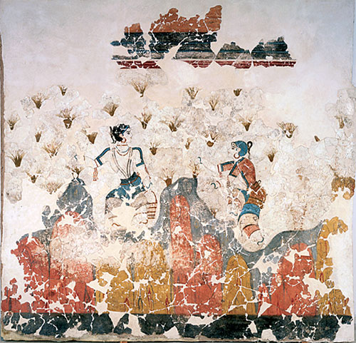


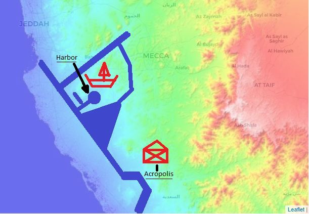


